Done with summer? Craving fall beers and pumpkin spice? You’ll love this 7-day forecast then. However, with that strong summer sun still around, it’ll be nice enough for the water, too.
Follow my work: www.cupajoe.live Jolt your brand, advertise with me: joe@cupajoe.live
📹SATURDAY’S FORECAST | My oh my, what a beautiful weekend! Sunshine, comfortable temps and good times. Highs will be 75-80F. ***However*** you need to avoid swimming in the ocean today, again and one more round of coastal flooding is on the way.
Captain’s Tree Service handles all your tree needs, including tree removals, trimming, pruning, and 24/7 emergency care. They’re reliable, affordable, and trusted by families. Call the Captain today for a free estimate at (856) 883-7682!
FRIDAY’S FORECAST | Don’t let the sunshine fool you. Erin continues to bring dangerous waves and coastal flooding today up and down the coast. Inland will be the place to be! How about the weekend? Let’s talk.
Today is the first of three bad days for the beaches. A tropical storm warning is in effect for the waters. Meanwhile, on land, we have a variety of surf and coastal flooding alerts out to keep us prepared. Let’s talk about what’s ahead, and the weekend.
Never worry about missing severe weather warnings again. Get a recorded call from me when your location is impacted. WeatherCall ensures you stay informed for just $15 a year. Sign up: https://ngorder.wxriskalerts.com/db_app2.php?station=cajx
I was on the phone with a Beach Patrol Captain Monday morning, talking about what Hurricane Erin would mean for the coastline.
His answer: We get these kinds of storms during the winter, but no one is in the water to experience the fury of the ocean.
Let me get this off the top. Swimming or boating in the ocean will be downright dangerous through Saturday and possibly into Sunday. Two people died in the surf the week of Aug. 11, one in Seaside Heights and one in Belmar. The waves weren’t even that rough. Using a personal watercraft (Jet Ski or Wave Runner) in the inlets will be dangerous, too.
Of less danger but still important, you’ll need to set up your beach chairs and towels closer to the dunes than usual. It’s possible salt water even reaches the dunes at high tides. Coastal flooding will be around each evening through Saturday.
This week’s indirect blow from Hurricane Erin is a good reminder of what the Jersey Shore experiences when the joy of summer here fades away, when the days turn gray and storm season eats at the sand. If you’re not a full-time resident in a beach town, this is what we experience in December or February, when the crowds are thin.
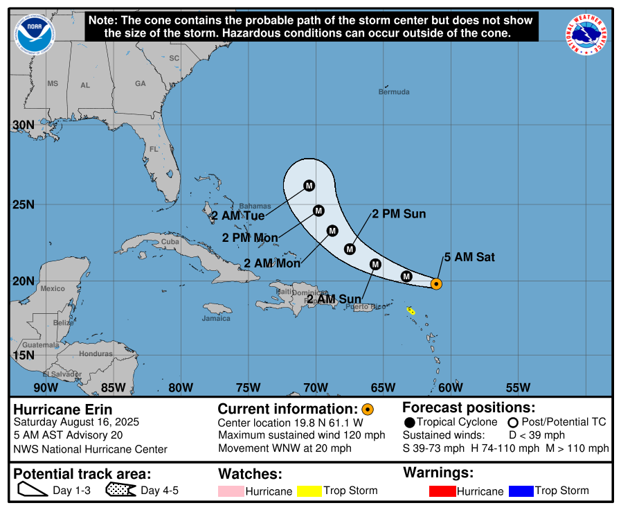
Hurricane Erin became a major hurricane, a category three, four or five hurricane, on Saturday, Aug. 16 with the 5 a.m. National Hurricane Center update.
The Saturday, Aug. 16 5 a.m. update from the National Hurricane Center on Hurricane Erin, the first time she became a major hurricane (via the National Hurricane Center).
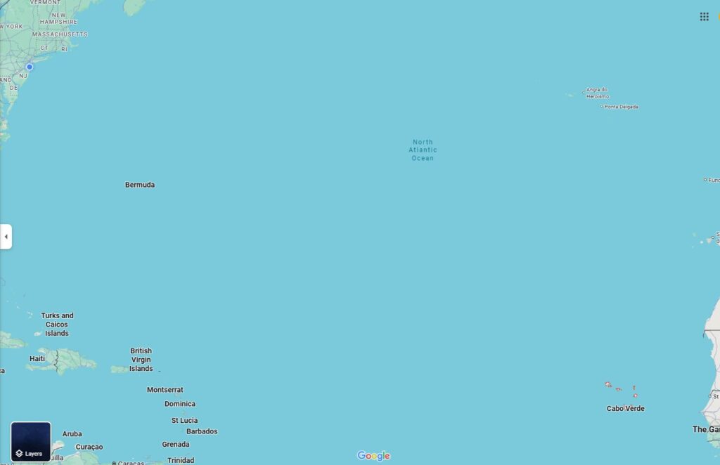
Erin was the first Cabo Verde hurricane of the year. Cabo Verde storms are the long track cyclones that originate off the West Coast of Africa, near the Cabo Verde Island. They then move west along the trade winds for days. From there, it either goes into the Caribbean Sea or Gulf. Alternatively, they curl northwest, north than northeast, parallel to the East Coast of the United States (major exception: Superstorm Sandy in 2012).
The Cabo Verde islands are outlined in red on the bottom right of the map. It’s located off the west coast of Africa (via Google Maps)
Erin’s will pass between Bermuda and North Carolina on Thursday, forecast by the National Hurricane Center to remain a major hurricane. It then only slowly weakens as it moves northeast, moving faster when it does so.
By the time it reaches the latitude of the Jersey Shore (roughly 39 to 40 degrees north latitude), it’ll be between 500 and 700 miles to our east. However, the storm will be stronger than usual for our latitude.
There are four reasons why Hurricane Erin will bring the most hazardous waters to New Jersey in years.
1) We won’t see rain. You can’t see the storm.
2) It’ll be breezy through Friday, and windy Thursday. However, it won’t cause wind damage or power outages. If you’re not looking at the ocean, it doesn’t look dangerous out.
3) This week is busier than usual for the coastal communities. Most summer camps are over, and most schools aren’t in session. The Beach Patrol Captain I spoke with said that.
4) The ocean is warm and enticing to go into. It continues to be one of the warmest, if not warmest on record for the Memorial Day to Labor Day period, according to Meteorologist Jim Eberwine of Absecon (also my weather-dad). Water temperatures have been well into the 70s.
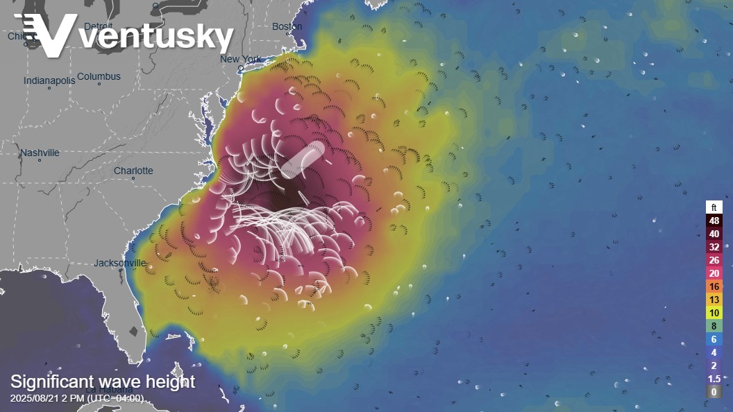
For the boaters
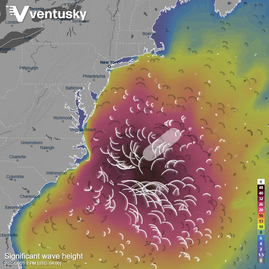
Significant wave height forecast forecast from government run computer forecast models (Via Ventusky).
A small craft advisory is in effect until Friday evening by the National Weather Service. It’s possible it will extend to Saturday.
The bays will be better but since smaller boats are in the bay, it will be hazardous, too. Seas will be three to five feet. For reference, the bay is typically one to two feet. There will be a big chop on the water, particularly late in the week.
For the surfers and swimmers
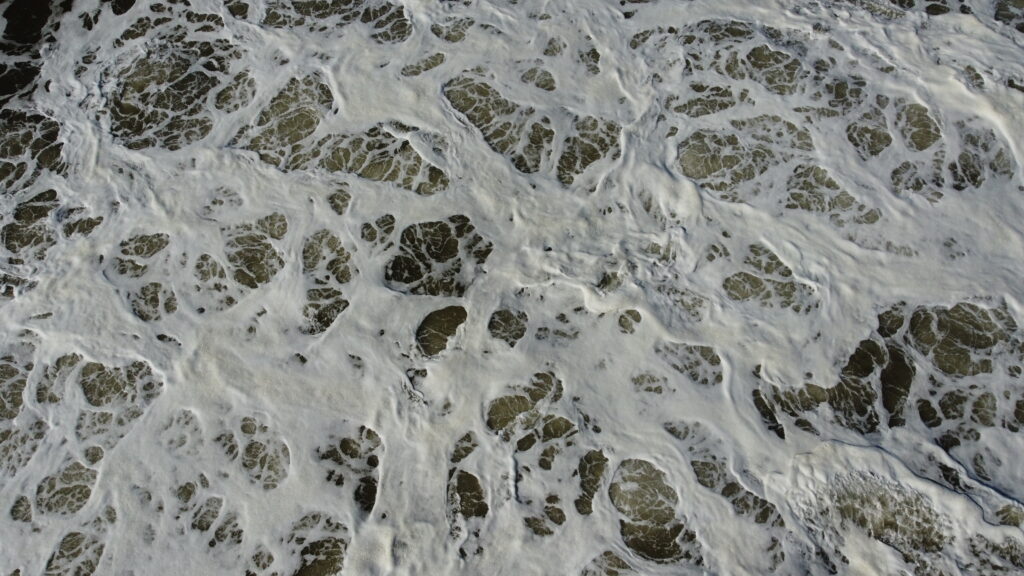
Hurricane Lee’s impacts on the ocean were seen Thursday in Atlantic City. Drone footage over and near the Atlantic Ocean shows high waves with foamy, white seas. Hurricane Lee will make landfall in either Maine, New Brunswick or Nova Scotia Saturday night, but impacts will be felt at the Jersey Shore until early next week. (Via Joe Martucci)
Surf heights will be at or over 5 feet until Saturday. Typically, the surf heights are less than three feet.
Not only will the waves be big, but they’ll have power to them. The wave period, which is the time it takes for two waves to pass one point, will be over 10 seconds through Saturday. It’ll peak for over 15 seconds on Thursday. The longer the wave period, the more ability it has to carry more water, making it more powerful. This also brings a very high risk for rip currents.
For reference, there will usually be a high risk of rip currents at nine seconds and a moderate risk after seven.
Surfers love these big waves. However, with winds in nearly the same direction as the southeast swell through Friday morning, these won’t give the clean waves surfers craving. Again, it’s dangerous and I don’t recommend anyone going in the water.
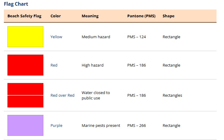
Your beach may show a red flag for an oceanic “high hazard”. It may also show a double red flag. That means the water is closed for public use.
You can expect to see many red or “red over red” (double red) flags on the beach this week due to Hurricane Erin (via United States Lifeguard Association)
“It’s going to look like a washer machine out there,” Eric Hoeflich, of the National Weather Service in Mount Holly, which covers the Jersey Shore, texted me. That’s true. Hurricane Lee in 2023 did have a white, sudsy look to the waves.
Again, the bay beaches will be the better place to get your sea water fix in.
For all people in a town that borders a bay
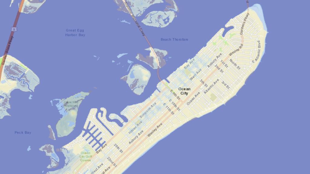
Coastal flooding will continue to extend until Saturday. This will mainly be during the evening high tides (find your flood forecast here). For two to three hours, expect up to six inches of salt water on low-lying bayside roads. This is the typical, or nuisance flooding, we see several dozen times a year. However, this is mainly from October to April, when some of you may be away from the Jersey Shore.
The blue areas indicate where you can see salt water at least covering the ground during minor flood stage in Ocean City (via ClimateCentral).
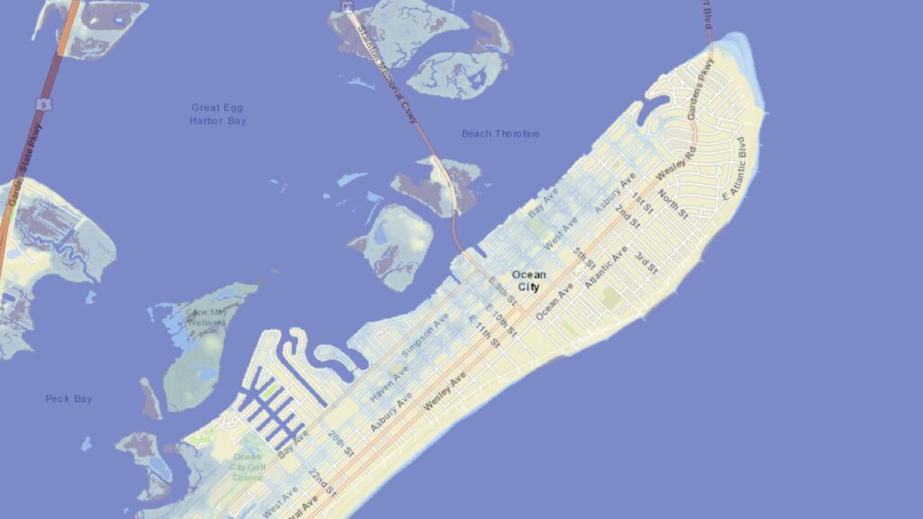
Be aware of Thursday evening’s high tide. Expect four to six hours of flooding here. Furthermore, prepare for moderate flood stage. This is when unraised buildings and homes begin to take on water. Up to ten inches of salt water are on low-lying roads and even roads that don’t typically flood do. In short, moving around the bayside towns is challenging for a stretch.
The blue areas indicate where you can see salt water at least covering the ground during moderate flood stage in Ocean City (via ClimateCentral).
Still, Enjoy the Jersey Shore
The Ventnor City Beach Concert at Ski Beach. The concerts, which take place on Wednesday evenings until the end of August, are a great way to spend time at the shore while the waves churn from Hurricane Erin.
The boardwalks will still be good. Ride the rides, eat the saltwater taffy, have a hurricane at the bar.
Daytime temperatures will be in the low to mid-70s. So, it’ll still be comfortable for a cookout, basketball or long runs.
In short, as long as you stay out of the water, there will be plenty of ways to enjoy this summer week.
The Atlantic hurricane season peaks from August to October.
This is the time to have your “go-bag” ready in case you need to evacuate. It is also the time to check hurricanes.gov (National Hurricane Center) on a daily basis, I’ll pass along more information from them later in this column.
Several major storms have fallen outside the hurricane season date range. Tropical Storm Fay hit New Jersey on July 10, 2020; Hurricane Isaias struck on Aug. 4, 2020, and Superstorm Sandy impacted the state on Oct. 29, 2012.
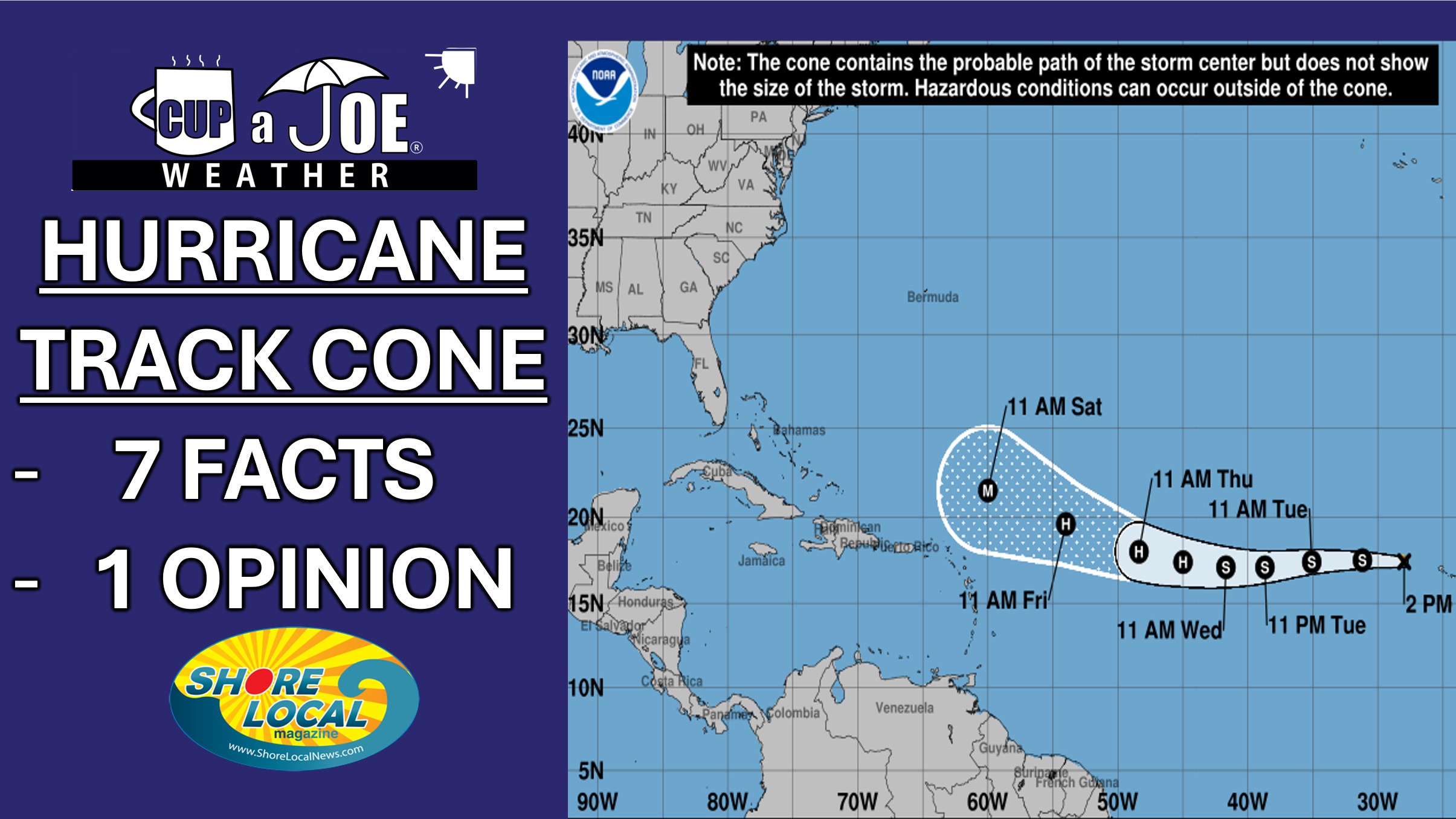
Nonetheless, now is the time to be extra vigilant. It’s a good time to learn more about what the National Hurricane Center track forecast cone is, especially as Tropical Storm Erin is churning in the tropical Atlantic Ocean.
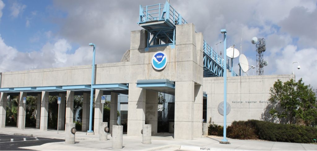
The National Hurricane Center (hurricanes.gov), a part of the National Oceanic and Atmospheric Administration (NOAA), is responsible for issuing all hurricane forecasts. Whether you follow me, another meteorologist in the news or elsewhere, that information all comes directly from the smart, hard-working folks at Florida International University in Miami.
Formed in 1943, their vision is to be “America’s calm, clear, and trusted voice in the eye of the storm and, with its partners, enable communities to be safe from tropical weather threats.”
Like most meteorologists, they use current observations and computer forecast model data to assist them in their forecasting.
In the spring, our “Tidal Flooding Talk” team of Dan Skeldon (a recognized name in local meteorology) and I interviewed Mike Brennan, director of the National Hurricane Center. You can learn more about the NHC during our conversation on YouTube.
The track forecast cone only predicts the path of the storm’s eye
The shaded area of the forecast cone only represents where the hurricane center forecasts the eye of the storm to go over. It has nothing to do with who will feel the impacts of the rain, wind or storm surge.
As we know, New Jersey experiences rough seas and large swells from tropical cyclones hundreds of miles away. Just last week, the week of Aug. 4, there were dangerous rip currents all over the Jersey Shore from Tropical Storm Dexter, which was never closer than 450 miles from the coastline here.
The center line does not represent storm path probability
The weather community has mostly moved away from showing the “center” line in the hurricane outlooks. It’s usually the line that connects the dots or symbols that show where the storm is forecasted to be located at a certain time.
There’s a good reason for it, too. The center line doesn’t mean anything except simply where the center of the cone is now. It doesn’t mean the hurricane center is most confident about it hitting there in the future.
Let’s use Superstorm Sandy in 2012 as an example. Three days before the storm, the center line was in the Delaware Bay. Turns out, it made landfall roughly 50 miles north of there, in Brigantine.
Via the National Hurricane Center
If the people making decisions on evacuations and emergency preparedness only used the center line, New York City and maybe Monmouth County wouldn’t have made the preparations that they did otherwise.
The track forecast cone covers a five-day forecast
The official forecast from the National Hurricanes Center covers a time span of five days. The location, storm strength, speed and pressure forecast are then given for 12, 24, 36, 48, 60, 72, 96 and 120 hours from the time of the forecast.
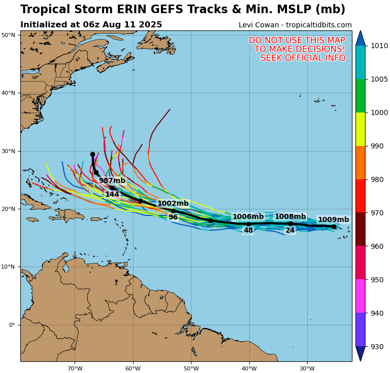
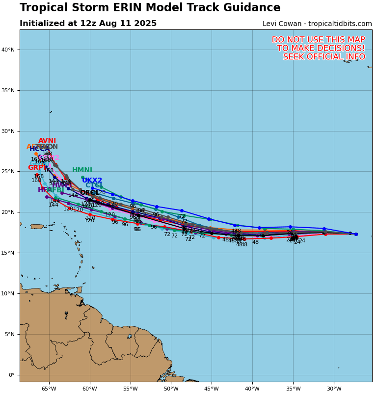
You may see computer forecast models run online or on television. Commonly known as “spaghetti plots,” they either show one computer model with slightly different variations to give you a fuller picture of where the storm could go (ensemble forecast), or a host of different computer models plotted on one chart.
On the left are ensemble member models, forecasting the track of the eye of the storm, from the Global Forecast System (GFS) model. On the right are a number of different hurricane focused computer models showing the track of the eye of the storm. (Via www.tropicaltidbits.com)
While they’re fine to show, do not use this as official guidance in your thinking process. The only official source for hurricane track information is the National Hurricane Center.
The track forecast cones widen over time due to growing uncertainty
The further out from the current time you make a forecast, the more likely something in the forecast will change. You may also know this as the butterfly effect, made famous by the Meteorologist Ed Lorenz.
For reference, the entire Jersey Shore, from Cape May to Sandy Hook, is 111 nautical miles.
Forecasting the track of tropical cyclones has improved dramatically
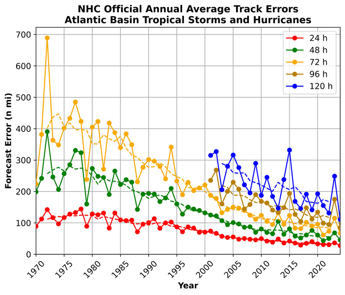
Due to massive upgrades in computer power, knowledge of meteorology and techniques, the track of Atlantic Basin hurricane forecasts is excellent. Here are a few facts that really stand out to me.
Today’s 72-hour (three-day) hurricane forecasts in 2024 are as accurate as the 24-hour forecasts were in 2000.
The 120-hour (five-day) hurricane forecasts in 2024 are as accurate as the 48-hour forecasts in 2000, and even the 72-hour forecasts during Superstorm Sandy in 2012, demonstrating significant progress in extended-range forecasting.
And my favorite, our five-day hurricane forecasts in 2024 are as accurate as the 24-hour forecasts were in 1970. The Pacific Ocean has seen a similar, vast improvement.
There’s been a vast improvement in the forecast of a tropical cyclone’s path in recent decades. (Via National Hurricane Center)
In other words, we have reduced the number of false alarms for evacuations and improved the ability to confidently issue evacuations in recent decades.
The track forecast cone is a 60-70% probability
While the weather community has made tremendous gains in tropical cyclone forecasting, the tropical cyclone is expected to remain within the track 60-70% of the time. Upperclassman-level high-school math is used to come to this conclusion. However, the hurricane center uses this probability to strike a balance between the hurricane’s potential path, and accounting for the uncertainty you get the further out you go.
Opinion: The track forecast cone should show the 75% probability
The National Hurricane Center has made tremendous progress in forecasting the track of tropical storms or hurricanes. At the same time, if you weren’t reading Shore Local, you’d have to dig through the internet to find that the cone you see has only a 60-70% probability of it happening. Therefore, to be more accurate, while also understanding the social science of how the cone is perceived, I believe it’s time to make the forecast cone bigger.
By going to a 75% probability, the storm you’re tracking has a 3 out of 4 chance of being within that forecast.
I asked AI (Grok) to compute the width of the forecast track cone if we used a 75% probability. This is what it came up with, compared to what it is now, with the current probability.
24-hour forecast: 45 nautical miles vs. 39 nautical miles.
120-hour forecast: 245 nautical miles vs. 213 nautical miles.
That would take us back to approximately the size of the forecast cone in 2010. For the increase in accuracy, I believe that’s a reasonable price to pay for getting it right more often.
Would you support a forecast track cone size this big if it meant being 10 to 15% more accurate on the path?
Joe Martucci, a Certified Broadcast Meteorologist and Digital Meteorologist, is the President and Director of Meteorology for Cup A Joe Weather and Drone. You can connect with him at cupajoe.sparkable.opalstacked.com/.
Enjoy this one! The sunshine will come out later Saturday morning and stay with us through the weekend. There are just two rain chances to talk about and they won’t change many of your weekend plans. Stay until the end because I talk about Hurricane Erin’s impacts on the water.
Captain’s Tree Service handles all your tree needs, including tree removals, trimming, pruning, and 24/7 emergency care. They’re reliable, affordable, and trusted by families. Call the Captain today for a free estimate at (856) 883-7682!
FRIDAY’S FORECAST | We need to recap last night’s rain because who did and didn’t rain was a *sharp* gradient. Then, we get to this weekend’s weather, which will be mostly dry, again! Next week gets rough in the water, as Erin gets closer to NJ.
Follow my work: www.cupajoe.live Jolt your brand, advertise with me: joe@cupajoe.live
Tropical Storm Erin continues it’s journey across the Tropical Atlantic Ocean Thursday morning. It’s pretty weak but is set to intensify into a MAJOR Hurricane over the weekend according to the National Hurricane Center. From there, high pressures will steer it. NJ is safe from direct impacts but indirect impacts? You bet.