
Tag: climate

  • Machine Learning hints at accurate weather forecasts 30 days out, disproving “butterfly effect”

    Machine Learning hints at accurate weather forecasts 30 days out, disproving “butterfly effect”

    NOTE: This story is a Grok summarized article on “Atmospheric Predictability Beyond 30 Days with Machine Learning” by P. Trent Vonich and Gregory J. Hakim. It was released in the Artificial Intelligence for the Earth Systems journal by the American Meteorologist Society, which I am a part of.

    Weather Forecasts That Last Way Longer Than We Thought Possible

    Scientists have long believed that weather forecasts can only be really accurate for about two weeks. After that, tiny mistakes in the starting weather data grow so fast because of chaos (the “butterfly effect”) that the forecast becomes useless. A new study challenges that old rule using an AI weather model.

    What They Did

    Researchers took a popular AI weather model called GraphCast. This model is special because it can “learn” from data and also figure out how small changes in the starting weather affect the forecast days later.

    They didn’t just run normal forecasts. Instead, they tweaked the starting weather picture (called the initial conditions) for every day in 2020 — over 700 forecasts in total. They used math to find the best possible starting point that would make the forecast match what actually happened as closely as possible. They did this step by step, starting with short forecasts and slowly making them longer.

    They tested this on a big computer using two levels of precision (like using more decimal places for more accuracy).

    What They Found

    The results were surprising:At 10 days ahead, the tweaked forecasts had 86% less error than normal forecasts that started from regular weather data. Every single forecast got better — none failed.

    The forecasts stayed useful much longer. The weather patterns matched reality well out to about 27–28 days, and some skill lasted past 30 days. The errors grew at a steady rate, but started from a much better place, so they stayed smaller for longer.

    They also checked if the AI was just making smoother, less detailed forecasts (which would look better but be less useful). It wasn’t — the improved forecasts kept the right amount of detail and activity.

    What the “Tweaks” Looked Like

    The changes they made to the starting weather weren’t random or tiny. On average, they showed a clear pattern:They made the big tropical air loop (warm air rising near the equator and sinking farther north and south) stronger than in the normal weather data.

    This included:

    Making some ocean areas near the tropics a bit cooler or warmer in the right places Adding or removing moisture in patterns that matched real weather systems Changing how air rises and sinks over large areas

    These changes were about the same size as normal small errors in weather data. They weren’t crazy or unrealistic.

    Testing in a Different AI Model

    To make sure this wasn’t just a trick that worked only in one AI model, they took the improved starting points and used them in another AI model called Pangu-Weather.

    The other model also got better forecasts — about 21% less error at its best point (around day 4). It wasn’t as big an improvement as in the first model, but it was still clearly better than normal. This shows the better starting points helped in general, but some of the improvement was specific to the first model.

    Why This Matters

    This study shows that better starting weather data can push accurate forecasts well past the old two-week limit — at least for big weather patterns across the whole planet. It suggests the atmosphere might be more predictable at large scales than we used to think, and that current weather data has some fixable mistakes in big patterns like the tropical air loop.

    Important limits

    The scientists knew what the weather actually did later (they were looking backward). This isn’t yet possible in real-time forecasts.

    It works best for big, continent-sized weather features, not tiny storms or local details.

    It took a lot of computer power for each forecast.

    Bottom Line

    The old idea that weather becomes unpredictable after about two weeks may not be as strict as we thought — at least when we use smart AI tools to find better starting points. This doesn’t mean we’ll have perfect 30-day forecasts tomorrow, but it opens the door to much longer useful forecasts in the future if scientists can figure out how to find these better starting points in real time.

    The study is careful and well-tested. It doesn’t claim the atmosphere has no limits — it just shows those limits might be farther out than we believed when we start with smarter data.
  • ⚠️”Extreme” Drought Returns to NJ and water restrictions may be next

    ⚠️”Extreme” Drought Returns to NJ and water restrictions may be next

    Extreme (level 3/4) drought returned to NJ in Cape May and southern Cumberland counties, according to June 11th’s update from the United States Drought Monitor. It’s now the worst statewide drought since March 2025. However, with it being summer, and water usage at its peak for the year, mandatory water restrictions are closer than ever.

    Nancy Adler Nutrition has practiced nutrition weight loss, naturally, for 30 years . Listen every Saturday to Nancy Adler Nutrition Live Saturday 11AM-1PM on WOND radio. Ready to lose the weight? Call Nancy at 609-653-4900.

  • 23 degrees! Why NJ gets HUGE temperature differences, like Tuesday.

    23 degrees! Why NJ gets HUGE temperature differences, like Tuesday.

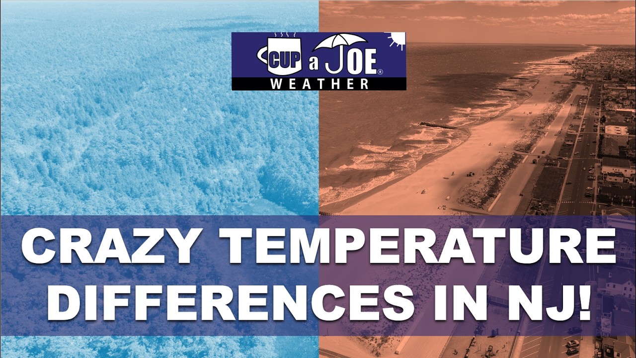
    For such a small state, NJ has BIG differences in temperatures sometimes. We went from low 40s in the Pine Barrens to the low 60s near NYC! Why? High pressure, clear sky and calm wind. Let’s look at the microclimates.

    Sparkable is your full-service marketing department for your brand. From SEO to social media to website development, we deliver innovative strategies to elevate your digital presence. Let Sparkable ignite your brand’s potential. sparkable.com

    Our 24×7 Jersey Shore Weather Channel: https://www.youtube.com/watch?v=dcPpb_VycOM

    Jolt your brand with the Shore’s top weather media company. Advertise today! joe@cupajoe.live

  • 🔥🧊Fire and Ice! 100F Wednesday for some in NJ. 60F for Friday?!

    🔥🧊Fire and Ice! 100F Wednesday for some in NJ. 60F for Friday?!

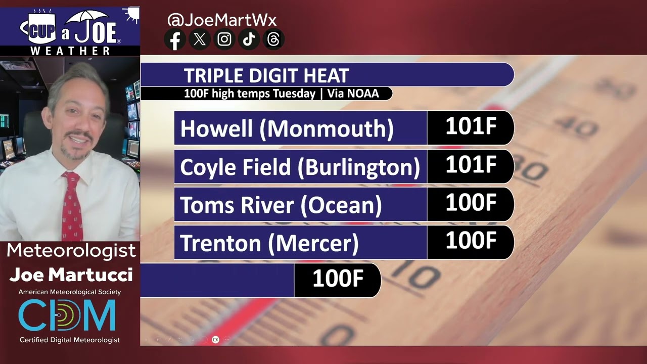
    WEDNESDAY’S FORECAST | Honestly, this could be our hottest 2 day stretch of 2026 and it’s only Mid-May! 100F for some again today. 60F by Friday. It’s like fire and ice!

    Memorial Day weekend? 1 washout but it’s pretty dry otherwise.

    Jolt your brand with the Shore’s top weather media company. Advertise today! joe@cupajoe.live

  • How do those cooling sea breezes form at the Shore?

    How do those cooling sea breezes form at the Shore?

    This article appeared in Shore Local News on May 14.

    We live by the sea breeze and die by the sea breeze.

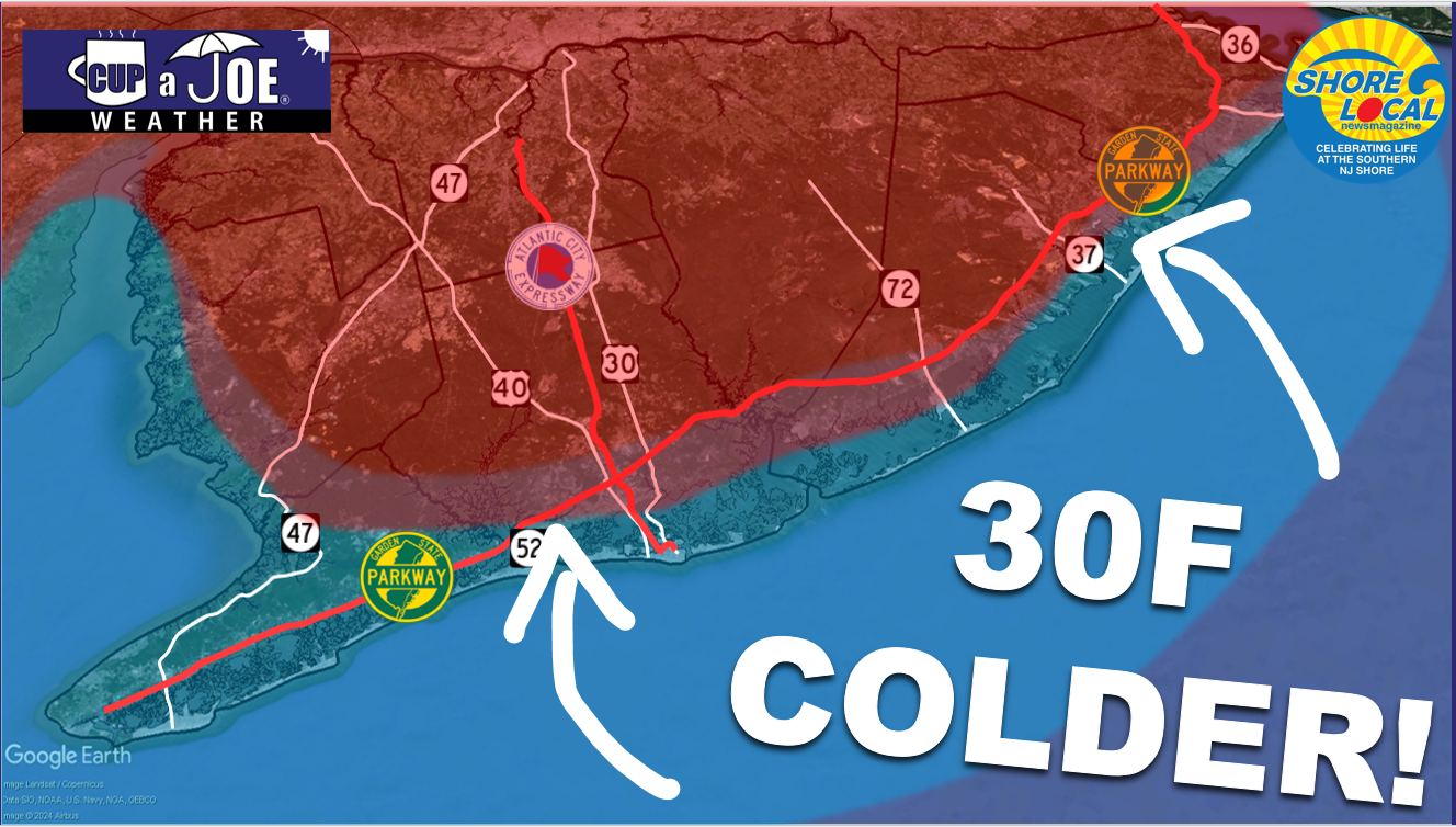
    Figurately, of course, but only kind of. How often has it been 95 degrees in Hammonton or Trenton, only to fall to 78 degrees in Ocean City or Atlantic City? That kind of change would make you feel alive if you made that trek to the beach.

    Alternatively, take May 4, 2026. It was 72 in Hammonton and Trenton. Atlantic City was 58 degrees. I have a feeling that took the life out of some outdoor plans.

    Even if you’re at the beach all day, how many times has it felt hot in the late morning? Then, you cool off with a refreshing breeze for the afternoon.

    Sea-breezes are a near daily occurrence of our lives for the Jersey Shore from roughly March to August. May is typically home to the strongest sea breezes and strongest differences between inland and coastal areas.

    The sea breeze makes the Jersey Shore the $20 billion economic engine it is according to the New Jersey Department of Tourism (2023). Doctors would prescribe patients time at the water’s edge to take in the cleaner air coming in from the ocean. Before air conditioning, the Camden and Atlantic Railroad, the West Jersey Railroad, Tuckerton Railroad and more opened the dream of refreshing summer air to the masses. Even today, the thought of a beach chair on the sand with the warm sun and cool breeze in your face is a pleasant sight.

    Why do sea breezes happen?

    In short, the sea-breeze is Planet Earth’s way to bring equilibrium to the atmosphere. The Earth is always trying to stay balanced against the constant change in the Earth’s tilt, orbit around the sun and more.

    In more detail, the sea breeze is caused by the sun warming up the land much faster than the body of water. It takes roughly 4.2 times more energy to heat up water a degree versus heating up land. Mainly, it’s because water, a liquid, can mix around, shifting its temperature around, faster than a patch of beach or forest can. The scientific phrase for this is heat capacity.

    Warmer air also brings lower air pressure. Cooler air brings higher air pressure. Winds always move from high pressure to low pressure. Due to physics, cooler air up to about 3,000 feet high will actually move onto land. That warmer air rises into the atmosphere. The line between the land breeze and sea breeze can create clouds. If there’s a lot of upward motion, it’ll even create rain showers.

    The red line in the spine of New Jersey are birds, insects and bugs being pushes east to west by the sea-breeze front (via the Office of the NJ State Climatologist)

    Sea breezes are localized features we call mesoscale features. It’s different than the widescale, synoptic winds that blow. If winds are blowing out of the northeast, off the water, due to a nor’easter, that is not a sea breeze. That’s just the way the wind’s blowing.

    Sea breezes typically blow at 10 to 20 mph.

    Mini cold fronts

    The cooling sea breezes we see in New Jersey are actually mini cold fronts moving in from the east. Typically, most cold fronts we think of in New Jersey come from the west or north. The drier, typically cooler air that follows the cold front are west or north winds. That is blowing in air from the larger area of high pressure in, say, Canada, replacing the lower pressure air.

    In New Jersey, the sea breeze cold fronts are stronger than other areas of the United States. That’s because of the Pine Barrens. The sandy soil of the Pinelands means the land heats up faster than other landmasses. It’s common for Egg Harbor City or Batsto to be the hottest place in the state. That creates a bigger air pressure gradient, which creates a stronger sea breeze.

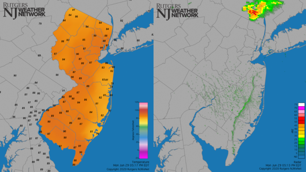
    A typical sea breeze look at temperatures (left) and radar. Note that Cape May County’s beaches are also in the 70s but there are no weather stations on the beach at this time.

    How to spot a sea breeze in NJ

    Keep in mind that northeast, east or southeast winds that blow for days at a time are not the sea breezes we’re talking about here.

    To have a real sea breeze, winds need to start out from an offshore direction and then shift onshore as the day goes on.

    First, you’ll need the sun to heat the ground for a few hours. A cloudy sky can bring a sea breeze during the late spring and summer, too, thanks to how strong the sun is.

    The strength of the wind matters, too.

    If winds are constantly blowing under about 15 mph, there’s a good chance the sea breeze will form during the late morning or midday if the large-scale winds are from offshore at first.

    As an example, if 10 mph from the southwest start off the morning, you’ll get a sea breeze to develop by noon.

    If winds are over about 15 mph, whether you see a sea breeze depends on the direction that large-scale wind is blowing.

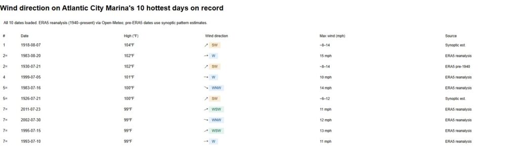
    Winds from the west or northwest will be too strong for the sea breeze to develop. They directly push back against it. These are the days that are the hottest on sand and inland. In fact, seven of the top 10 hottest days at Sen. Frank S. Farley State Marina in Atlantic City had a wind out of the westerly or northwesterly direction, according to Open-Meteo and ERA5 data.

    Claude.ai helped with this analysis of Atlantic City’s hottest days on record, and their wind direction.

    Sadly, it’s also the days when the bugs swarm the shore all day long.

    However, winds from the southwest or north at those higher speeds don’t directly push against the developing sea breeze. Typically, they’ll still form.

    The Delaware Bayshore also gets cooling sea breezes, but they’re not as noticeable since the bay temperature is more in line with the land temperatures nearby. There isn’t as much as an air pressure gradient that creates that cooling wind.

    Still, for Cumberland and Salem counties, any wind that isn’t pushing directly against the coastline or with it can cause a sea breeze.

    For Cape May County’s Bayshore, a south or north wind can still develop those localized sea breezes.

  • NJ’s drought situation keeps getting worse (May 14th update)

    NJ’s drought situation keeps getting worse (May 14th update)

    A “severe” drought (level 2/4) drought now engulfs 50% of New Jersey, including most of the Jersey Shore, according to the United States Drought Monitor on May 14. That’s 30% increase from last week.

    The NJ Department of Environmental Protection put the state in a drought warning in November. However, if widespread, soaking rain does not come in the next month, mandatory water restrictions would be possible. That comment comes from State Climatologist Dr. Dave Robinson from our Monthly Weather Roundup show on May 5.

    Our 24×7 Jersey Shore Weather Channel: https://www.youtube.com/watch?v=dcPpb_VycOM

  • Lunch & Learn about Tidal Flooding on May 20th with Joe Martucci, for free!

    Lunch & Learn about Tidal Flooding on May 20th with Joe Martucci, for free!

    The Cape May Lutheran Church has invited Joe Martucci to speak at their Lunch and Learn on Wednesday, May 20th. Now, this year, they added a Zoom option for everyone up and down the Jersey Shore. It’s free!

    The event starts at 12PM. Joe will speak about changes in tidal flooding over the decades, as well as give an outlook on the 2026 hurricane season. NJ has a 19% chance of being within 50 miles of a tropical storm or hurricane, lower than average.

    Sign up: https://us06web.zoom.us/meeting/register/ZAA12XzUR1y6FkIoDuCA_g#/registration

  • Worse drought, record heat & killing freeze | April 2026 Monthly Weather Roundup

    Worse drought, record heat & killing freeze | April 2026 Monthly Weather Roundup

    Drought continues for the sixth month in a row in New Jersey, according to the state’s Department of Environmental Protection. Now, though, other indicators are showing warning signs of a crippling drought, too.

    Believe it or not, April was in the top 10 for warmest Aprils since records started in 1895. That’s true even though April 21 brought a killing freeze to most of New Jersey only seen once or twice a decade.

    Recap the month of weather that was. It’s all Jersey, with two of Jersey’s best weather guys. New Jersey State Climatologist Dr. Dave Robinson as well as Meteorologist Joe Martucci, owner of Cup A Joe Weather and Drone, take you through it all.

    New episodes come out the beginning of every month.

    Listen and watch to all episodes: https://rss.com/podcasts/nj-monthly-weather-roundup/?_gl=1%2aun7y2p%2a_gcl_au%2aMTY1MTUyMjgzMC4xNzcxOTUxNDUx

    NJ Climatologist’s Office: www.njclimate.org

  • Why this snowy winter was NOT enough to cure NJ’s 2026 drought

    Why this snowy winter was NOT enough to cure NJ’s 2026 drought

    This article initially appeared in Shore Local News on April 30, 2026

    It’s unanimous, according to the state and federal agencies in charge of keeping track of drought conditions.

    Since November, New Jersey has been in drought, according to the state Department of Environmental Protection. Then, on April 14, the Jersey Shore was put into drought by the United States Drought Monitor, only to cover the entire state a week later.

    When I talk about this in my weather videos, or post about it on social media, some variation of the same question comes up.

    “How could the Jersey Shore be in drought? We had so much snow last winter.”

    While yes, we did have well-above-average snowfall (26.1 inches at Atlantic City International Airport, 18.6 inches in Margate, and 39.2 inches in Long Branch), but lots of snow doesn’t necessarily cure a drought. The correlation is pretty weak.

    Drought is defined as “a period of abnormally dry weather sufficiently long enough to cause a serious hydrological imbalance,” according to the American Meteorological Society. In other words, if the water going into the environment is less than the water being taken out of the environment (by humans, animals, evaporation, etc.) for a long period of time, you go into drought.

    Water comes into the environment by precipitation. Snow is precipitation, so is rain. However, on average in New Jersey, it takes 11 inches of snow to get 1 inch of precipitation. Meanwhile, 1 inch of rain equals 1 inch of precipitation.

    Snow to liquid ratio climatology. On average for New Jersey, it takes 10 to 11 inches of snow to produce one inch of precipitation. (via the National Weather Service)

    Here’s a look at how much snow, precipitation and average precipitation fell at Atlantic City International Airport from December to February:

    In December, there were 2.2 inches of snow, 3.03 inches of precipitation, vs. 3.76 inches of average precipitation.

    January saw 6.7 inches of snow, 3.78 inches of precipitation, vs. 3.44 inches of average precipitation.

    February recorded 17.2 inches of snow, 3.53 inches of precipitation, vs. 3.12 inches of average precipitation.

    Snowfall was about 75% above average during this time. Precipitation was about 5% below average.

    What about the snowpack?

    This winter probably felt extra long because the snow was on the ground for so long. Twenty-nine days had at least 1 inch of snow covering the ground at Atlantic City International Airport, according to the National Oceanic and Atmospheric Administration, the sixth longest since records began in 1945.

    default

    Snow on the ground helps prevent drought from worsening. It allows for snow to slowly melt and seep into the ground. It also prevents the sun from pulling water from the ground and evaporating into the atmosphere.

    However, the snowpack wasn’t deep enough nor did it hang around long enough to have a significant impact on the drought.

    All things considered, it was a lack of precipitation in March that slid the Jersey Shore into a deeper drought.

    Drought outlook for NJ

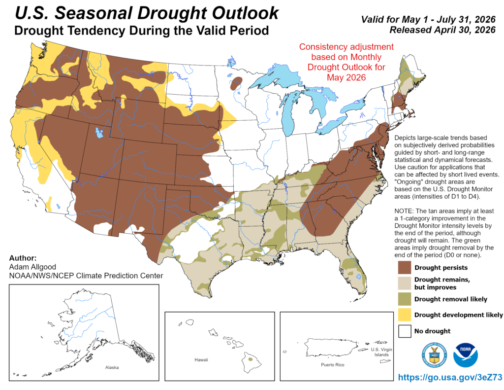
    NOAA is forecasting that drought conditions will persist through the end of July, according to its April 30 update.

    Precipitation across the Jersey Shore, not just in a town or two, needs to average at least 5 inches during this time in order to drown out the drought. More than 4 inches of evaporation occurs during June and July.

    We’ll need a few coastal storms, or a very gloomy next month or two, in order to do that. If not, don’t be surprised to see mandatory water restrictions by the end of the summer.

  • Warm, finally. Dry, still.  March 2026 Monthly Weather Roundup

    Warm, finally. Dry, still. March 2026 Monthly Weather Roundup

    After 3 straight months with colder than average temperatures, March winds up not just warm, but in the top 20 warmest going back to 1895! One thing that didn’t change was precipitation. The Jersey Shore wound up much drier than average and NJ State Climatologist Dr. Dave Robinson is concerned about wildfire season.

    Recap the month of weather that was. It’s all Jersey, with two of Jersey’s best weather guys. New Jersey State Climatologist Dr. Dave Robinson as well as Meteorologist Joe Martucci, owner of Cup A Joe Weather and Drone take you through the temperatures, rain, snow, coastal flooding and much more every episode.

    New episodes come out the beginning of every month.

    Listen and watch to all episodes: https://rss.com/podcasts/nj-monthly-weather-roundup/?_gl=1%2aun7y2p%2a_gcl_au%2aMTY1MTUyMjgzMC4xNzcxOTUxNDUx


    Cup A Joe Website: www.cupajoe.live
    NJ Climatologist’s Office: www.njclimate.org