📹THURSDAY’S FORECAST | I’m calling it. We will see a coastal storm Sunday PM – Monday AM in NJ. However, snowfall totals, and how much tidal flooding there will be still needs to be worked out. In the meanwhile, the shore gets much needed rain over the 24 hours. Let’s talk!
📹WENDESDAY’S FORECAST | Be careful driving/walking in this fog! Otherwise, much needed rain is on the way through Friday. Remember, we’re in drought.
And yes, I’m still tracking a possible snowy Sunday coastal storm, too. 🙂
If your personal forecast feels uncertain this winter, support is available. See You Through It Counseling offers in-person and virtual therapy for children, adults, and couples. Invest in healing that lasts. Visit seeyouthroughitcounseling.com or call 856-335-1352.
Here’s my first rule – climate change is not a religion. You don’t believe in it or not. It’s happening and humans are the cause of it. Whether that’s great for us, bad for us, is not for me to say. That’s where your beliefs come in.
Now, onto the data.
Our long cold snap from the last week of January to Valentine’s Day only broke ONE cold temperature record at both ACY and Atlantic City, our main weather reporting stations. In other words, we’ve had this cold before.
What about the length of it? ACY and AC went 7 days with temperatures under 32F. That’s good for 10th all time at ACY Airport (records back to 1943) and 16th all time in Atlantic City (records back to 1873).
In other words, it’s been colder, for longer several times before.
And those several times before are generally a long time ago.
At ACY Airport 7 of the 9 longer sub-freezing streaks happened before 1980.
In Atlantic City, 13 of the 15 longer sub-freezing streaks happened before 1980.
Climate change doesn’t mean “it’ll never be cold again”. It’s just that it needs to be more unusually cold to produce the same cold as before.
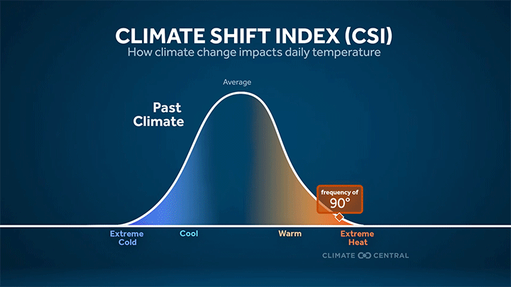
On the opposite end, we can break heat records with less impressive heat. Record warm outpaces record cold more than 3x over in the past 15 years.
I love cold and snow more than most people. I’m not saying how to feel about climate change or not. You are all great and many of us understand that facts/forecasts is not the same as the politics of it.
📹TUESDAY’S FORECAST: Happy Chinese New Year! It’s the year of the Fire Horse. No fires this week, just much needed rain showers that will alleviate this drought. I’m also watching snow and a winter storm for Sunday – Monday, again.
If your personal forecast feels uncertain this winter, support is available. See You Through It Counseling offers in-person and virtual therapy for children, adults, and couples. Invest in healing that lasts. Visit seeyouthroughitcounseling.comain- or call 856-335-1352.
📹SUNDAY FORECAST | It’s a special update! I have an updated look at who snows and who doesn’t tonight as a coastal storm slides to our south.
Never worry about missing severe weather warnings again. Get a recorded call from me when your location is impacted. WeatherCall ensures you stay informed for just $15 a year. Sign up: https://ngorder.wxriskalerts.com/db_app2.php?station=cajx
SATURDAY’S FORECAST | I’m looking over the data and I can’t deny it. Some snow will fall with our weak coastal storm Sunday night! Otherwise, it’s a seasonable weekend ahead, for a change.
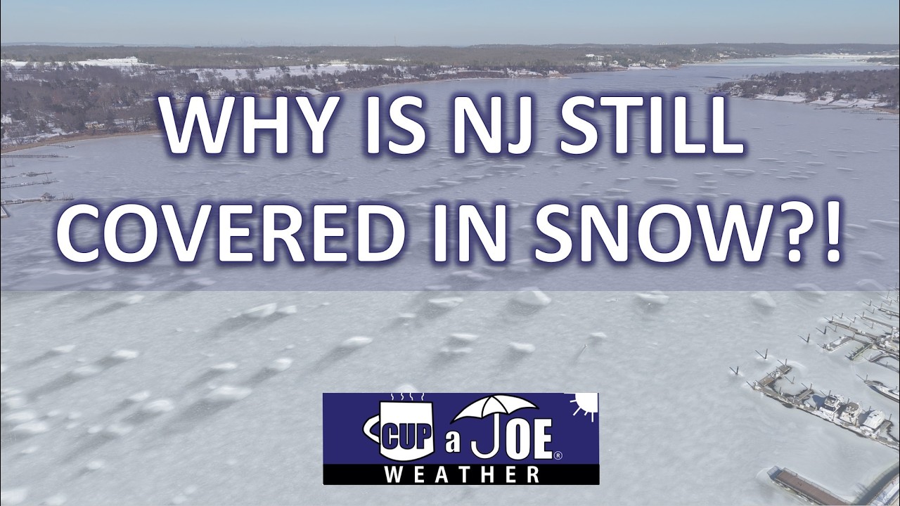
This snowpack on the ground is on a generational run. It’s not going away. Friday marks 20 straight days with snow and ice on the ground.
At Atlantic City International Airport, that’s the 4th longest since records began in 1945. The last time it was longer than this was 24 days in 2010.
Long Branch has had at least 6″ of snow cover for these 20 days. That’s the 5th longest streak since records began in 1907. You’d have to go back to 1961 to have this much snow on the ground for this long. Even at just 3 inches, it’s the longest streak since 1978.
Quite literally, a generational run.
So why is this snow so stubborn to melt? There are many weather reasons.
Let’s start with the most obvious, the cold. That’s keep the ice in place.
Since the winter storm on January 25th, anywhere from just 1-3 days has been in the 40s, according to NOAA. That’s it. Most days have been below freezing.
In fact, Jan. 23 to Feb. 12 has been in the top 4 coldest on record at New Jersey’s major weather stations.
At ACY Airport, the past 3 weeks have felt more like a typical stretch in Portland, Maine, according to the Southeast Regional Climate Center.
Atlantic City has felt more like Milwaukee.
Plus, the nights have been absolutely frigid for the most part.
Going hand in hand with this is the sun. Sun helps melt the snow, but if it’s below freezing, it can only sublime the snow, going from a solid to a gas, like water vapor.
That’s been happening, but at a slow process. Using Long Branch as the example, the depth of the snowpack went from 10″ on Jan. 26 to only 6″ on Feb. 13, just only 1 days in the 40s.
Next, you’ve seen it all around you, this snowpack is more like an ice cube!
Our winter storm on Jan. 25 was unique. Snow went to 1″-3″ of sleet. That makes the liquid density 2-3 more dense than a similarly deep snowpack comprised all of snow, the National Weather Service says.
Then, freezing rain and rain only added more moisture. That deep freeze after that just locked all of that into place.
The least obvious one is the dew point, or measure of moisture in the air.
When dew points are above freezing, air temperatures are above freezing. So, that will melt the snow pack. However, it also has an even bigger role than that.
Dew points above freezing causes water vapor to turn to liquid water on the snowpack. This change then releases heat, that melts the snow faster, even if the air isn’t super warm.
And as you can probably tell by your chapstick usage, it’s been very dry.
Since the Jan. 25 winter storm, no days has had a dew point above freezing at the Jersey Shore. Even when the air temperature is above freezing, that doesn’t do much to melt the snow.
The result? A Delaware Bay that’s nearly completely covered in ice, slush in the ocean water, ice skating on the Wildwood Beach and the return of the historic Van Nostrand Cup on the frozen Navesink River on Feb. 9.
FRIDAY’S FORECAST | After weeks of mostly frigid temperatures, biting wind and growing ice on the water, this weather pattern ends Friday. Temperatures rise into the 40s and 50s from here. Plus, we even have much needed rain, instead of snow, in the forecast.
THURSDAY’S FORECAST | Forget about Dry January, we’re living in Dry February across the Jersey Shore! We’ve seen near 0″ of precipitation this month. That’ll change late this weekend and if you’re a snow lover, there is a path toward the white stuff falling!
Our 24×7 Jersey Shore Weather Channel: https://www.youtube.com/watch?v=lGssDGu6xk0