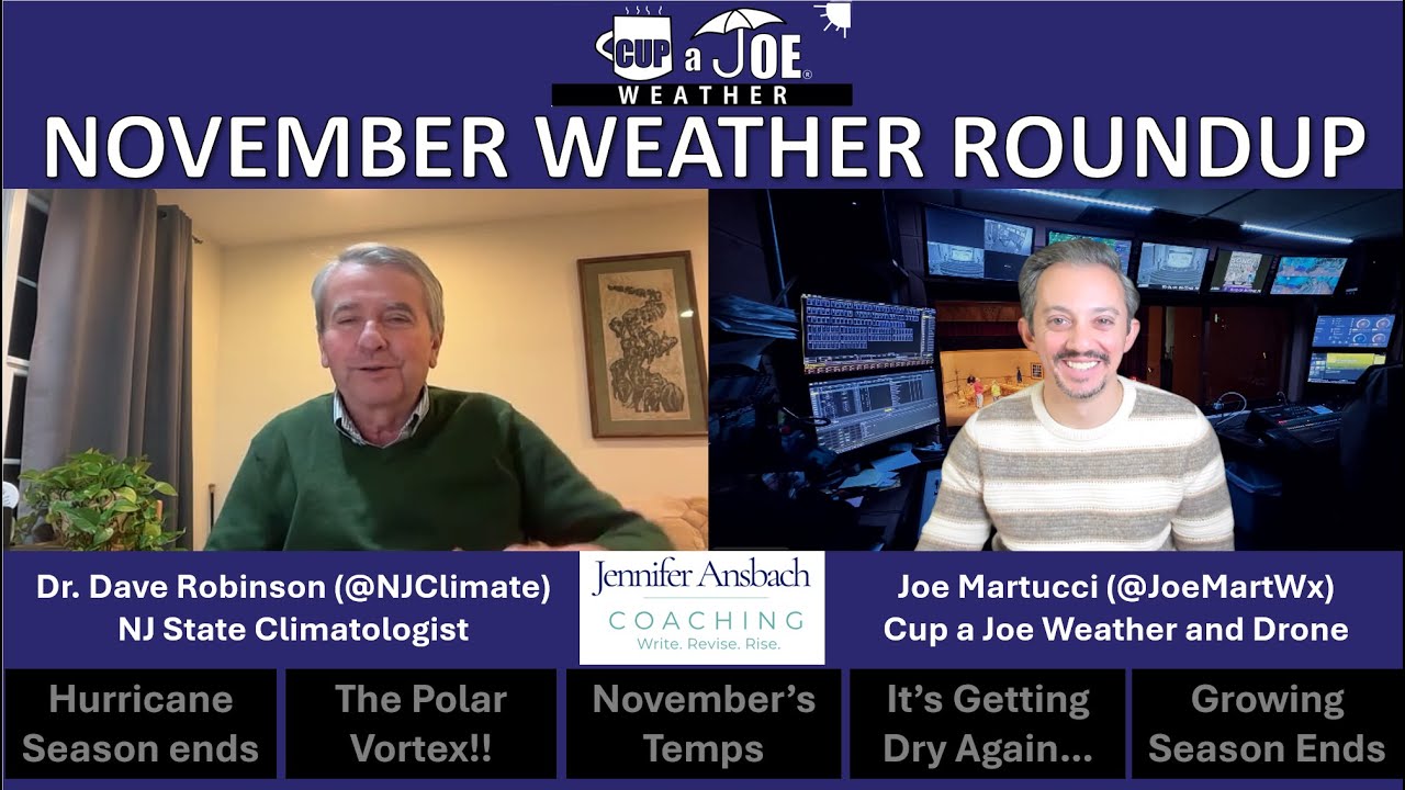
Joe Martucci and NJ State Climatologist Dr. Dave Robinson recap November 2025: near-average temperatures, very dry conditions (only ~2″ of rain), the end of a U.S.-landfall-free hurricane season, scattered early flurries, a disturbed polar vortex, and growing drought concerns heading into winter.
Recap the month of weather that was. It’s all Jersey, with two of Jersey’s best weather guys. New Jersey State Climatologist Dr. Dave Robinson as well as Meteorologist Joe Martucci, owner of Cup A Joe Weather and Drone take you through the temperatures, rain, snow, coastal flooding and much more. New episodes come out around the beginning of every month.
The Monthly Weather Roundup is sponsored by Jennifer Ansbach Coaching — helping students and adult learners Write. Revise. Rise. Learn more at JenniferAnsbach.com.
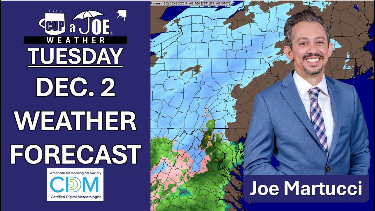
TUESDAY’S FORECAST: Woo-wee, we have a interesting week of weather ahead. It’s a soaking rain for the Jersey Shore weather today, enough to possibly break record in Atlantic City and ACY Airport. We don’t get the snow that Taylor Ham land gets. However, we will have the same bitter cold as them later this week. It’ll be cold for even late January. Tune in.
🎄 Come to the Ventnor City Twilight Holiday Parade presented by AutoLenders on Saturday, December 6th. It’s sure to jingle all the way! Festivities begin at 4PM. The Mummers will be performing, too! #OnlyinVentnor
🏈🔴RUTGERS FOOTBALL WEATHER: It’s like this. In one football game, PSBooo can go home for the season, while we go bowling. It’ll be cold. But dress warm, bring the body warmers and cheer loud. We got this.
Located just 1/3rd of a mile from SHI Stadium, the St. George Greek Orthodox Church is THE place to park and tailgate for Rutgers football games! Lots of space, clean bathroom and excellent service. Reserve your space at www.rutgersparking.com.
THANKSGIVING WEATHER FORECAST | Cold Turkey today, Blue Friday tomorrow! Cold is the name of the game in the chilliest holiday since 2018. That’s something you can talk about at the dinner table if the conversation runs dry. Enjoy!
Follow my work: www.cupajoe.live Jolt your brand, advertise with me: joe@cupajoe.live
Blasts of frigid for December air may be NJ’s reality this December thanks to an unusual chain of events bringing the polar vortex.
Meteorologists like me are keeping a close eye on the sky above the North Pole. We’re watching for something called a sudden stratospheric warming (SSW). If an SSW happens, it’s like poking a big, spinning cold-air circulation called the polar vortex.
When you poke it, the vortex can wobble and send frigid air south. That cold air could slide all the way down to New Jersey in the middle of December. If it does, we would get temperatures that are way colder than normal.
If this occurs, that means December will be more like “Decembrrr,” with it “beginning to look a lot like Christmas,” as the Perry Como song goes.
What is sudden stratospheric warming?
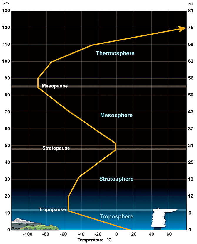
Sudden stratospheric warming is a process in which the temperature of the stratosphere, the second lowest layer of Earth’s atmosphere, warms quickly. Typically, this is about 30 to 50 degrees within a week.
The layers of the atmosphere on Earth (Via NOAA)
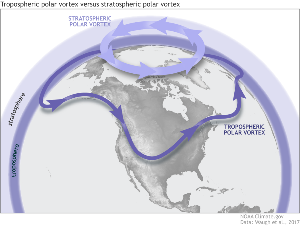
When this occurs, the polar vortex — the spinning area of very cold, westerly winds in the stratosphere that typically sits over the North Pole — is disrupted. When that happens, it can do one of the following:
Split into two or more pieces, pushing south from the North Pole.
Winds weaken dramatically or even reverse and come out of the east.
Stretch itself farther south.
When you hear that the polar vortex is disrupted, that means the stratospheric polar vortex. The stratospheric polar vortex likes to spin counterclockwise at the North Pole in the Northern Hemisphere. However, can be disturbed by a SSW event (Via NOAA).
Note that SSWs can only occur during roughly October to April, when the polar vortex is strong. Outside of this time, the polar vortex is weak and essentially hibernates for the warm season.
What does polar vortex disruption mean?
When the polar vortex is disrupted — in this case by sudden stratospheric warming — the stratospheric vortex can shift over parts of the Northern Hemisphere, usually between 40 and 65 degrees north latitude. The Jersey Shore sits between 38.9 and 40.5 degrees north latitude.
The extremely cold air in the stratospheric vortex almost never mixes directly down to the surface. Instead, the SSW changes the large-scale circulation, which then allows pre-existing surface-level Arctic air (from northern Canada, Siberia, etc.) to plunge southward in the troposphere.
The jet stream – the river of air about 30,000 feet high which separates polar and tropical air masses – becomes wavy, moving south to north to south again. The jet stream is in the troposphere.
That clash of warm and cold air from the jet stream also causes cold-core storms, like a nor’easter, to form at the surface. Put that on the East Coast and position the cold air from the jet stream exactly right, and New Jersey has a snowstorm.
However, not all polar vortex disruptions impact New Jersey, or even the East Coast. The frigid cold can spill into the Great Plains, like it did in February 2021 when much of Texas was without power. It can go to Europe, or Asia, too.
How often do sudden stratospheric warming events occur?
When they do happen, they’re typically in January or February. As MIT’s Cohen said, never in the satellite era has an SSW event happened in November. November SSWs were observed in 1958 and 1968, but in an era before high-tech weather satellites, high-altitude airplane observations and more, this isn’t a reliable claim.
The most recent SSW event in the Northern Hemisphere was in early March of this year. It quickly brought the end of the polar vortex season. In fact, it was the second earliest SSW to end the cool season since 1958.
What do early sudden stratospheric warmings mean for N.J.’s winter?
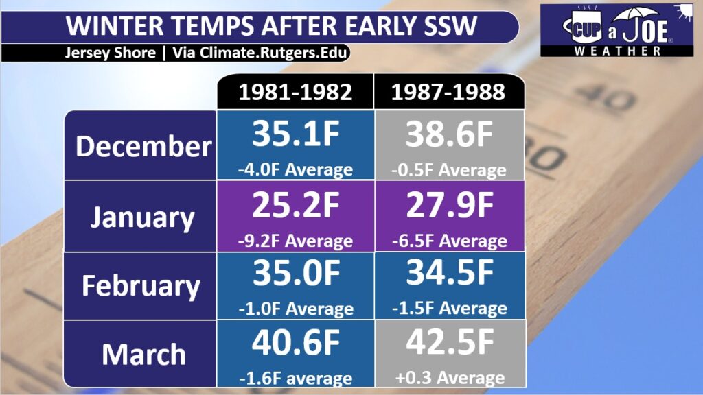
Two winters had SSWs in early December: 1981-1982, and 1987-1988, according to Cohen.
Both of those followed the same pattern when it came to temperatures. January was at least 6.5 degrees colder than the current average. January 1982 was the sixth coldest January on record for the Jersey Shore going back to 1895, according to the Office of the New Jersey State Climatologist.
February was also below average, but less so, between 1 and 2 degrees.
December and March had differences, too. In 1981-1982, both months were colder than average. December was a whole 4 degrees below average.
The winter a few years later saw above average temperatures for December and March.
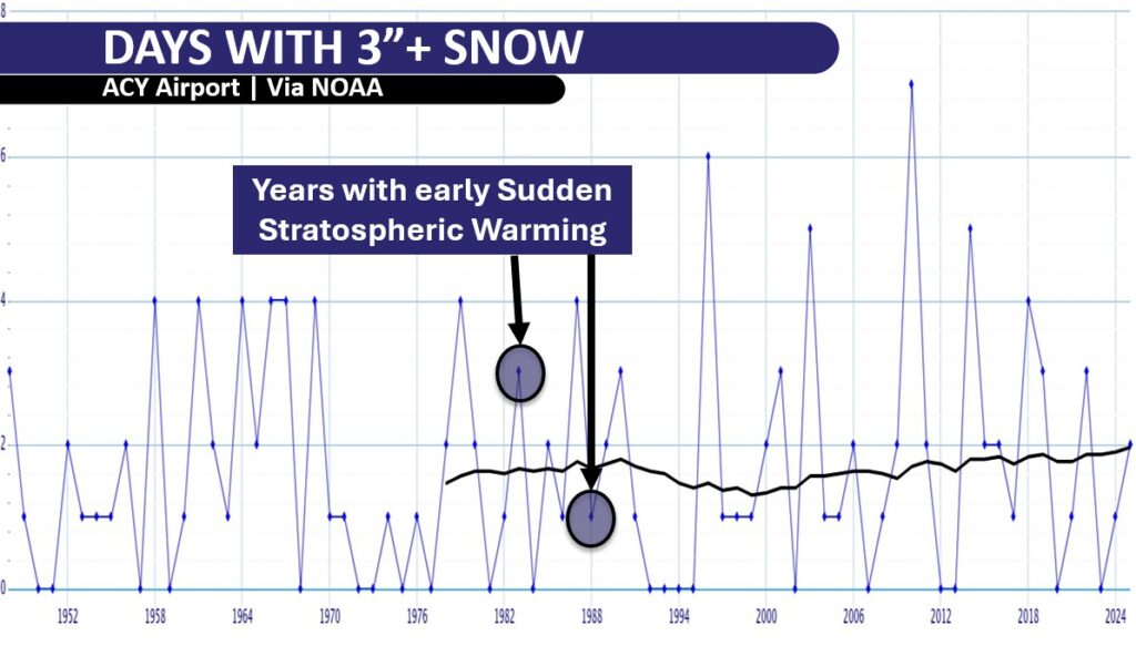
All that cold doesn’t translate to snow, though. Both the winters of 1981-1982 and 1987-1988 saw two days with more than 3 inches of snow at Atlantic City International Airport, according to the National Oceanic and Atmospheric Administration. That’s about average.
Other parts of the shore had the same fate. In Lower Township, Cape May County, 3 or more inches of snow occurred on just one day in winter 1981-1982. The 1987-1988 winter had two days.
Long Branch, Monmouth County, only had data for the winter of 1981-1982. However, even there, 3 or more inches of snow occurred twice, which is below average. Big cold doesn’t always translate to big snow.
What can we expect this december?
Like my winter outlook story said, we need to watch for an early start to the cold and perhaps snow in the first few weeks of December. First, we have to wait and see if that sudden stratospheric warming (SSW) happens this week up in the Arctic.
If it does happen, follow me online for updates. I’ll watch where that super-cold Arctic air will rush down to the ground. We will know by the first few days of December if that cold air is heading for New Jersey or not.
If it does come to New Jersey, it would mean an extended period, or maybe a few prolonged periods, between Dec. 10 and Dec. 31, when it is much colder than average. We are talking daytime highs only in the 30s. At night along the shore it would drop to the 20s, and inland it would get down to the teens when clear.
We are still weeks away from the coldest part of winter, so those numbers are pretty cold for December.
It is still too early to make a clear snow forecast. However, temperatures in the 30s are much better for snow than temperatures in the 50s. So if we get that cold air, I expect at least some snow that sticks to the ground.
Stay tuned for more updates, and Happy Thanksgiving to you, your friends and your family. Enjoy the free $400 ShopRite turkey.
Joe Martucci, a Certified Broadcast Meteorologist and Digital Meteorologist, is the President and Director of Meteorology for Cup A Joe Weather and Drone. You can connect with him at cupajoe.sparkable.opalstacked.com/.
WEDNESDAY’S FORECAST | Happy Travel Day! The good news is if you’re headed back to the place you love, the Jersey Shore, you had no weather issues. Most airports across America are fine, too.
However, we do have a rollercoaster ride of temperatures. Even the turkey will want to go cold turkey and quit this chilly Thanksgiving air.
TUESDAY’S FORECAST | Warm and wet turns cold and dry this Thanksgiving week!
🎄 Come to the Ventnor City Twilight Holiday Parade presented by AutoLenders on Saturday, December 6th. It’s sure to jingle all the way! Festivities begin at 4PM. The Mummers will be performing, too! #OnlyinVentnor
SATURDAY’S FORECAST | Don’t fret. Morning showers will give way to plenty of dry weather the rest of the weekend! Also, I have a better (colder) feel for how Thanksgiving looks up and down the shore.
Stream Live: www.cupajoe.live Jolt your brand, advertise with me: joe@cupajoe.live
At the start of this month, I went to Sea Isle City to give a talk to the Garden Club. The group of ladies was nice, and one of them asked me a question that was a lot like this one.
“Has it been windier weather at the Jersey Shore lately?”
Sea Isle City isn’t the only town to ask this. From Cape May to Ventnor and points north, this has been a popular question during my public, and private, weather talks. The uptick in questions started in 2021 and 2022 and persisted. However, this may be a question of perception and not reality.
How has the wind changed at Jersey Shore?
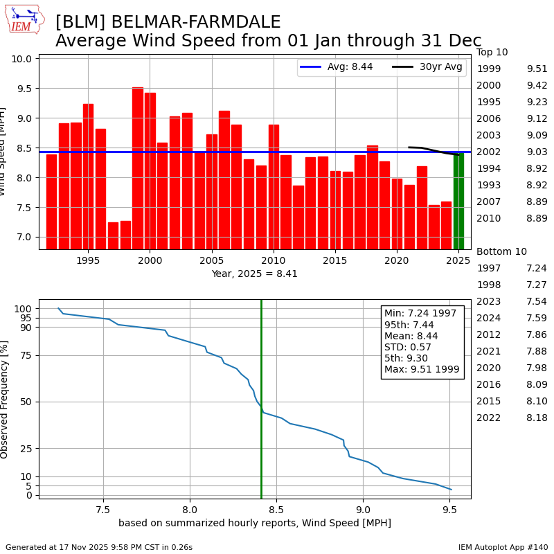
Believe it or not, the winds have been calmer at Jersey Shore in recent decades.
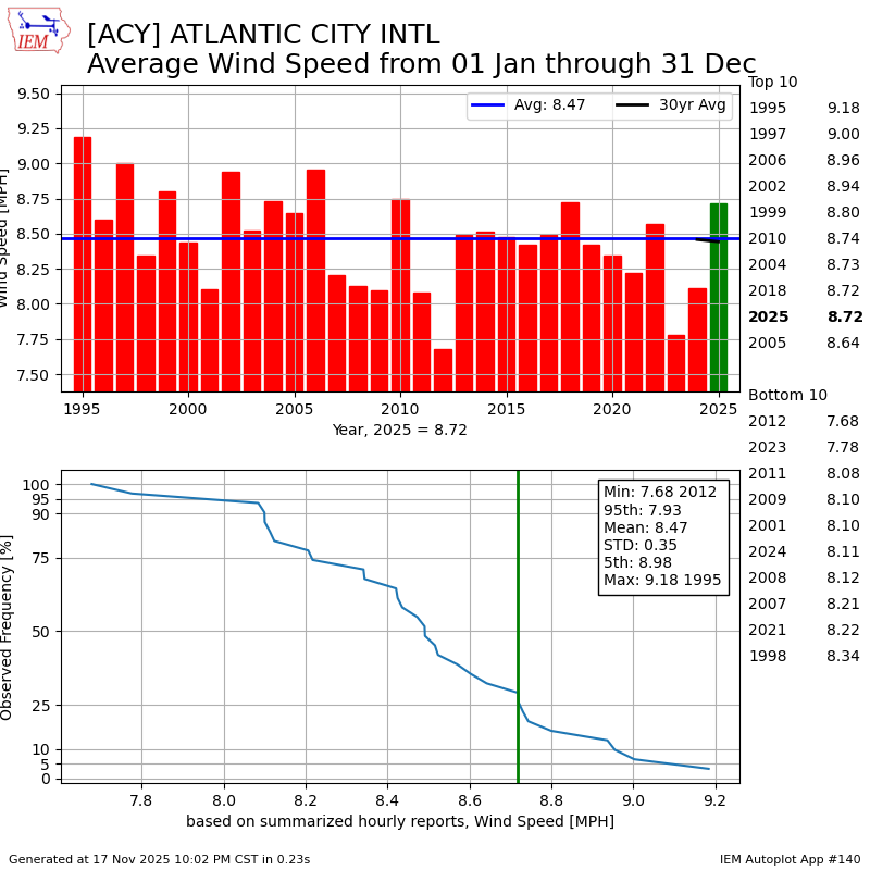
At Atlantic City International Airport in Egg Harbor Township, the average wind speed in 2024 was 8.11 mph, according to the Iowa Environmental Mesonet. While that was above the 7.8 mph average in 2023, wind speeds have been in decline for a while.
Consider that during the past 30 years, the trendline for winds decreased from about 8.7 mph to 8.2 mph. That’s not much, but it proves the point that the wind speed has not increased in recent years.
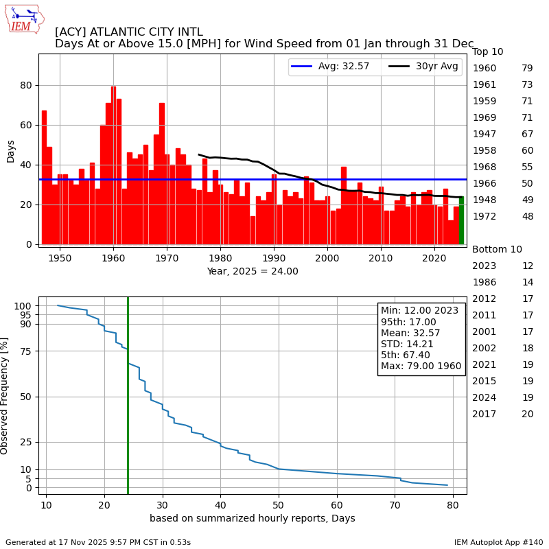
To prove this is true another way, I even sorted by the number of days in a year with sustained winds of at least 15 mph. That’s a breezy day.
Again, there’s been a slight decline in the number of days. As of Nov. 17, ACY Airport experienced 24 such days. That is more than the past two years, but the longer-term trend shows a decline.
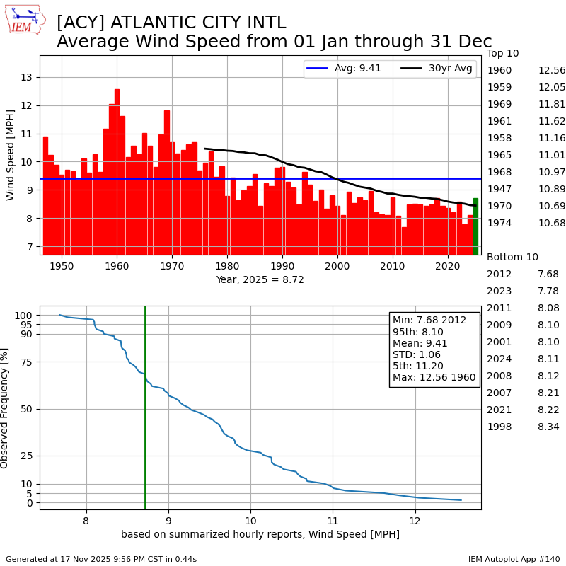
It is interesting to see the big drop in the wind speeds that occurred in the 1970s. The long-term average dropped from 10.5 mph from 1947 to 1976, to 9.0 mph from 1977 to 2006.
More than likely, the wind equipment used at the airport changed at some point in the 1970s. That led to weakening wind speeds.
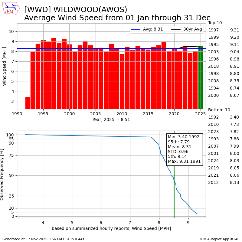
Going beyond ACY Airport, the Iowa Environmental Mesonet data in other places prove that the windier days are just perception. The average wind speed at Lower Township’s Cape May County Airport has remained consistent at around 8.2 mph since records began in 1992.
Meanwhile, at Monmouth County Executive Airport in Wall, the trendline is also pointing toward calmer years. 2025 is the first year that was as windy as at the average since 2018, getting to 8.4 mph through Nov. 17. Windier-than-average years were the norm from 1999 to 2007.
Have very windy days happened more often in N.J.?
It depends.
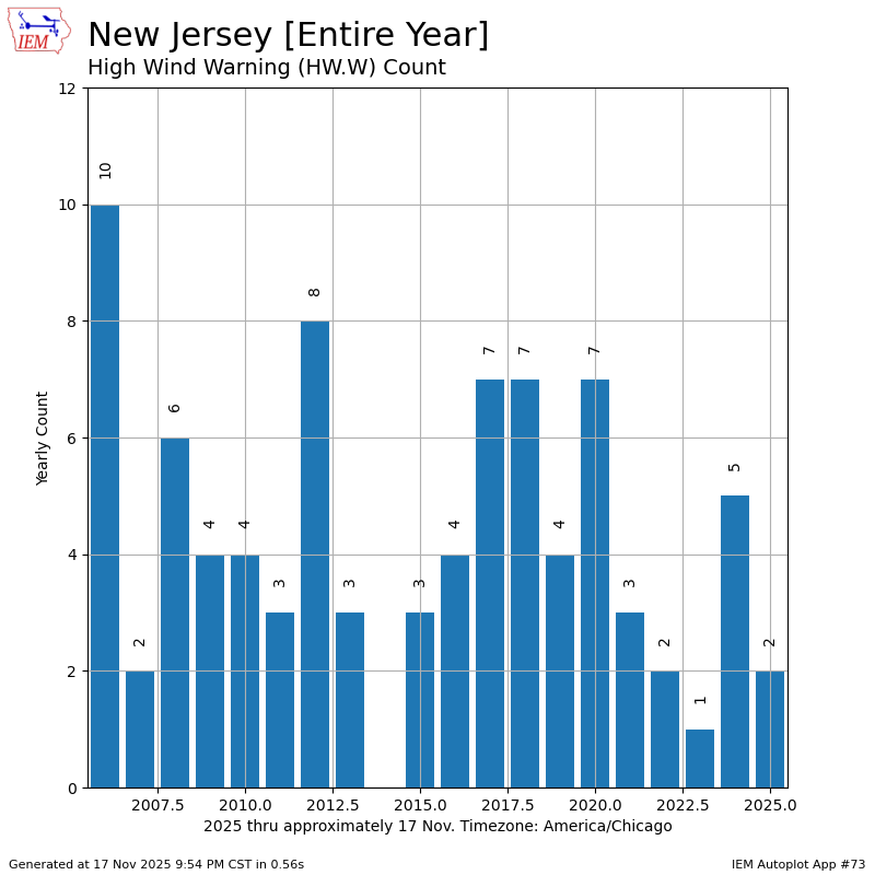
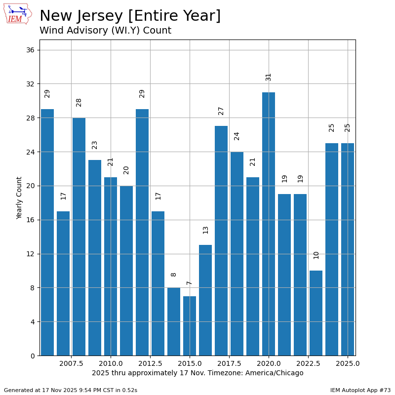
Since records began being kept in 2006, the trendline for the number of wind alerts issued by the National Weather Service has fallen over time in New Jersey.
High wind warnings, which are issued by the weather service when winds can damage life or property, occur 4.5 times a year, according to the mesonet. However, that’s a slight drop from the first 10 years of records, which was 4.7 times.
Meanwhile, wind advisories that are issued for nuisance wind issues saw a slight increase. The average since 2006 has been 20.7 times per year. The first 10 years of record keeping was 19.9, though.
With the average wind speed dropping over time, and the most severe winds happening slightly less often, don’t look too much into the bump up in wind advisories.
Why is it feeling windier in N.J.?
I don’t have any scientific evidence for this, but here’s my theory on why it’s felt windier in recent years.
We’re outside more.
From 2020 to 2021, in the depth of the COVID-19 pandemic, many of us that were healthy rekindled our relationship with the great outdoors. More walks and runs outside. More time in the garden or at cookouts. More time at the beach.
All of that may keep us in tune with the wind more than before. As outdoor workers will tell you, wind does impact the ability to get things done. So, perhaps that’s why.
Otherwise, the data says we must keep searching for answers because it hasn’t been windier.
Twenty-four/seven streaming weather channel now LIVE
Whether on your TV, your computer or your phone, get everything Jersey Shore weather, and drone, for free!
The Cup A Joe Weather and Drone Jersey Shore streaming weather channel is now live. From our daily weather forecasts to Tidal Flooding Talk, words from our sponsors and more, you’ll get the hyper-local information you deserve, without the hype.
You can submit your most scenic weather photos for the stream, also. Go to www.bit.ly/WxPhoto to put yours in. We’ll approve it and you’ll see it run, live, on your device. Just search for @joemartwx on YouTube or go to www.cupajoe.live to view it.
Joe Martucci, a Certified Broadcast Meteorologist and Digital Meteorologist, is the President and Director of Meteorology for Cup A Joe Weather and Drone. You can connect with him at cupajoe.sparkable.opalstacked.com/.