THURSDAY’S FORECAST | Forget about Dry January, we’re living in Dry February across the Jersey Shore! We’ve seen near 0″ of precipitation this month. That’ll change late this weekend and if you’re a snow lover, there is a path toward the white stuff falling!
Our 24×7 Jersey Shore Weather Channel: https://www.youtube.com/watch?v=lGssDGu6xk0
📹WEDNESDAY’S FORECAST | Break out the shorts, break out the flip flops, it’s our warmest day in weeks at the Jersey Shore!
(OK, it’s not that warm but it’ll feel nice out).
If your personal forecast feels uncertain this winter, support is available. See You Through It Counseling offers in-person and virtual therapy for children, adults, and couples. Invest in healing that lasts. Visit seeyouthroughitcounseling.com or call 856-335-1352.
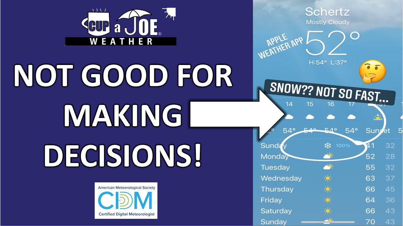
That’s the point founder Joe Martucci made to NJ.com in this article about non-degreed Meteorologists and generic weather apps. Find the article below!
With temperatures much colder than average around here, the depths of winter have been feeling more like New England than the Jersey Shore.
From Jan. 18 to 31, temperatures at Atlantic City International Airport were what the same typical two-week period would be in Portland, Maine, according to the Southeast Regional Climate Center. From Jan. 25 to 31, the mean temperature at Atlantic City International Airport was just 18.6 degrees. You’d have to travel far north to find similar readings. Anchorage, Alaska, is the closest match. The same is true at the Sen. Frank S. Farley State Marina.
Days of sub-freezing temperatures and nights with sub-zero windchills are certainly bitterly cold. However, you don’t have to look that far back to find Januarys just like it.
Believe it or not, January 2026 was milder than last January at both the airport and the marina, according to the National Oceanic and Atmospheric Administration (NOAA).
At Atlantic City International Airport, the average temperature for January was 30.8 in 2026, compared to 30.6 during the same period in 2025. Both readings fall a little below the mean of 33.0. At the Atlantic City Marina, the average was 32.7 in 2026, up from 32.1 in 2025, but still below the 34.5 mean. Even up the Jersey Shore at Long Branch, Monmouth County, 2025’s January was just 0.7 degrees milder.
In other words, January 2025 was colder. However, I hear you, 2026 just felt more frigid.
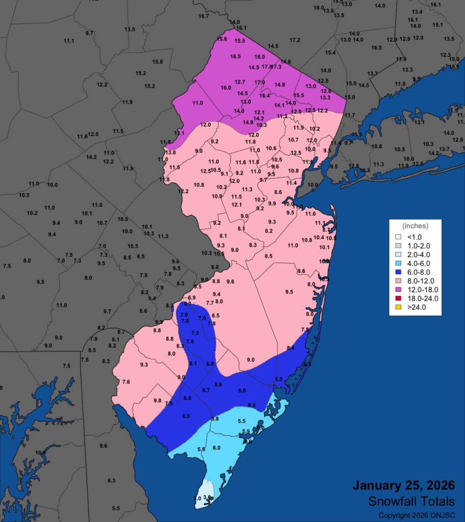
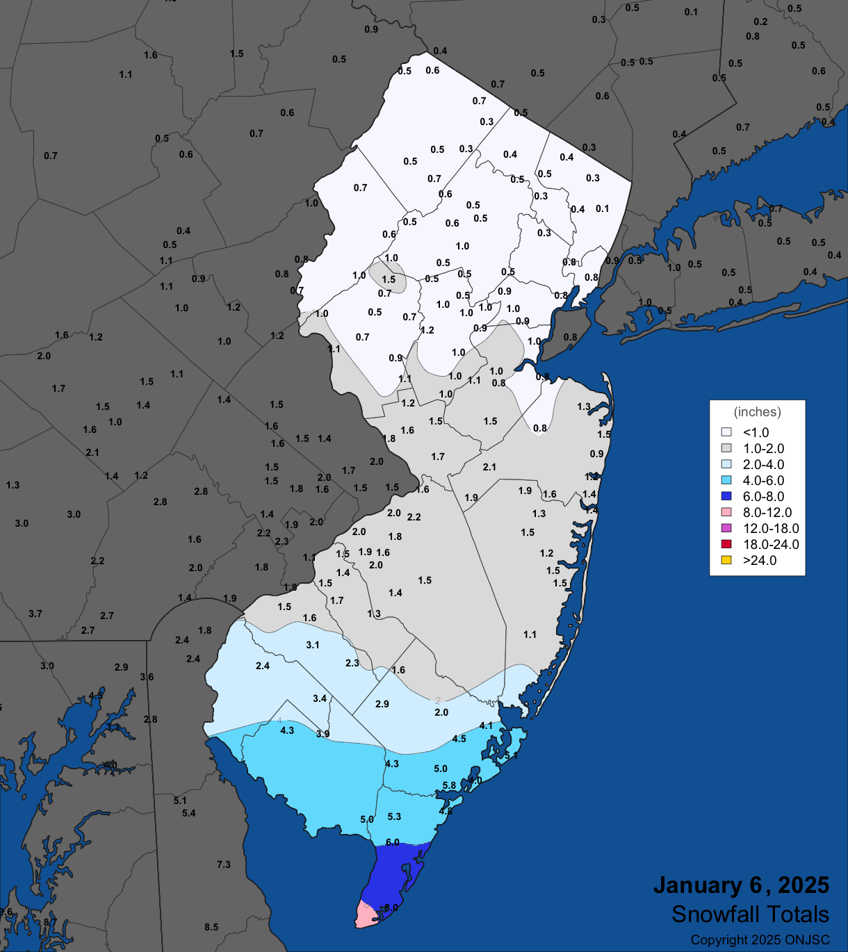
Maybe it’s because of the snow. Last January experienced a South Jersey Snow Special on Jan. 6. Six to 10 inches of snow fell in Lower Cape May County, with a plowable snow south of the Atlantic City Expressway. However, it was gone a week later. Meanwhile, our winter smorgasbord from Jan. 25 to 26 continues to be an icy glacier more than 10 days later.
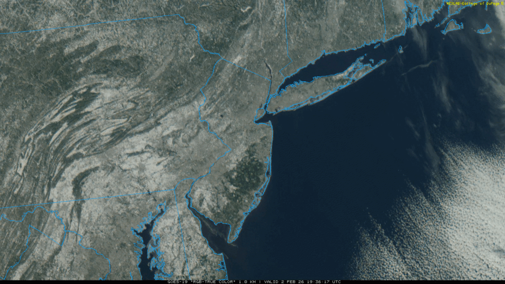
A snow covered Mid-Atlantic from Feb. 2, 2026 on the visible satellite image. Note the green area in eastern New Jersey. That’s the dense forest of the Pine Barrens. There was still snow on the ground there. (College of DuPage)Snow and sleet totals from the Jan. 25, 2026 Winter Storm (Office of the New Jersey State Climatologist)
Maybe it’s because, compared to average, New Jersey is among the coldest places in the United States this winter, according to Ben Noll of the Washington Post.
Maybe it’s because our coldest days were colder. Five days were 15 or more degrees below average at ACY Airport this year. Last year, there were three. It was nearly the same in Atlantic City.
Otherwise, maybe it’s just because we remember only what happened to us lately. Last January had more days with gusts over 45 mph, according to NOAA, compared to this January.
Bay ice concentration in the Mid-Atlantic last January, at its peak (48.72%), was double what it was at its peak this January on Jan. 29 (20.5%).
Compared to the rest of recorded history, this January was just a little colder than average. In our climate-changing world, it’s been harder to achieve long stretches of bitterly cold temperatures.
Last month, the only cold temperature records that occurred within our four, long-standing Jersey Shore weather stations (Lower Township, Atlantic City International Airport, Atlantic City Marina and Long Branch) were:
Atlantic City Marina tied a record cold maximum temperature of 22 degrees on Jan. 30. Long Branch broke the cold maximum temperature record with 18 degrees on Jan. 31.
That’s not much. New Jersey had the 39th coldest January of 132 years of record keeping, Dave Robinson, the New Jersey state climatologist said on my Monthly Weather Roundup show. The coastal zone, which is generally anywhere east of the Garden State Parkway, was the 41st coldest.
December and January are as cold as the 1960s at Atlantic City Marina. ACY Airport was like an average one in the 1980s.
The climate is changing at a rate not seen since the end of the Paleozoic period 250 million years ago, according to research reported in Science magazine.
Looking ahead, February looks like it will be a colder-than-average month. That would be our first meteorological winter (December-February) colder than the long-term average in quite some time. However, if you’re done with the cold, keep in mind that the days are getting longer and it’s a little light past 6 p.m. now.
The more bitterly cold time of the year is behind us. Warmer days are on the way.
The ice was so thick on the Wildwood beach, videos and photos of people ice skating on it went viral throughout New Jersey. I headed to the frozen sheet to explain the weather process behind the icy scene.
The biggest New Jersey winter storm of the 2025-’26 season so far brought the roads, rails and skies to a halt on Sunday.
An atmospheric river from the South Pacific collided with an Arctic air mass, creating near-perfect conditions for a significant winter storm on Jan. 25. However, this was not a pure snowstorm.
A layer of above-freezing temperatures roughly 5,000 to 14,000 feet high eventually turned powdery snow into sloppy sleet late morning and early afternoon. This transition, though, came after several inches of snow was recorded around the area.
Atlantic City International Airport recorded 6.2 inches of snow and sleet by the time the storm ended Sunday night, according to the National Oceanic and Atmospheric Administration (NOAA). Other totals in Cape May and Atlantic counties included:
Buena Vista – 6.7 inches
Hammonton – 6.3 inches
Ventnor – 6.0 inches
Ocean City – 6.0 inches
Woodbine – 6.0 inches
Cape May – 5.0 inches
Similar to the Dec. 14 storm, the northern half of the Jersey Shore cashed in on the snow and sleet. Point Pleasant reported 10.3 inches, Long Branch had 10.5 inches and Brick reported 10.9 inches.
Snow and sleet totals for the Jan. 25, 2026 storm, via the Office of the New Jersey State Climatologist.
The highest totals were in far northwest New Jersey. Not only was it all snow, but it was powdery snow. That was thanks to unusually cold temperatures during the snow. It was in the single digits with heavy snow. You just don’t see that often in New Jersey.
Also unusual was the split in precipitation type across the state. The Jersey Shore warmed from the teens to the upper 20s by late Sunday morning. It was snowing. However, along the New Jersey Turnpike corridor in South Jersey, it was sleeting, despite temperatures in the mid-teens. It could have been much snowier, too.
When you look at coastal storms you look at the track to give you an idea of who will receive snow, a mix or rain. Typically, when low pressure systems go over 40 degrees north latitude, 70 degrees west longitude, that brings all snow to the I-95 corridor, with mixing where we are, farther east. This low pressure system was farther west, though, roughly 74 degrees longitude at 40 degrees north latitude.
Meteorologists call this the “benchmark.” However, the center of the storm was only about 50 miles east of Atlantic City at one point. Yet, we snowed and got sleet, with rain only falling in Cape May, Atlantic and Ocean counties. That was because of the brutally cold air mass we had Saturday. High pressure to the north was feeding in Arctic air. If the low pressure went over the typical benchmark, it would have been fair to say that 12 to 20 inches of snow and sleet would blanket the coastal counties, similar to the Blizzard of 2022.
Snowfall was mostly in line with expectations and road conditions remained treacherous into Monday.
Remember, generic weather apps are not human curated and can change on a dime, as it just spits out whatever blend of computer models they use.
Meteorologist Jon Rocco created most of this report. You can follow him on Facebook or X.
THURSDAY’S FORECAST | Fitting for National Weatherpersons’ Day… a lot to talk about. Possible snow squall Friday evening, wind chills colder than last weekend and even lows below 0F. Let’s get into it!
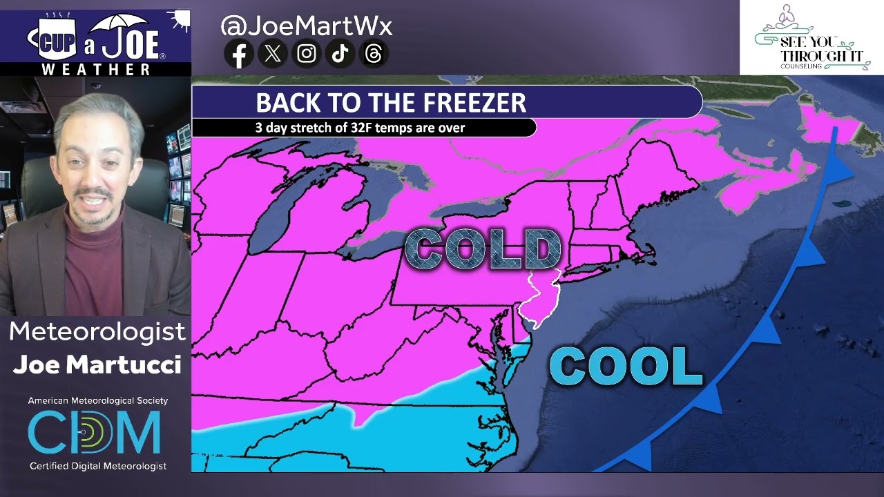
WEDNESDAY’S FORECAST | The 3 day stretch of temperatures above freezing are over. Goodbye summer lol. Now, it’s back to a sub-freezing air and a Super Bowl weekend that could be COLDER than anything we’ve seen this winter.
If your personal forecast feels uncertain this winter, support is available. See You Through It Counseling offers in-person and virtual therapy for children, adults, and couples. Invest in healing that lasts. Visit seeyouthroughitcounseling.com or call 856-335-1352.
TUESDAY’S FORECAST | Welcome to our mildest day in 11 days! Even still, highs will be colder than average and snow showers are in the forecast for part of the Jersey Shore.
Not only that big another bitter blast will unload on NJ later this week. This one could be even colder than the last.
If your personal forecast feels uncertain this winter, support is available. See You Through It Counseling offers in-person and virtual therapy for children, adults, and couples. Invest in healing that lasts. Visit seeyouthroughitcounseling.comerse or call 856-335-1352.
The Monthly Weather Roundup focused on January’s weather patterns, particularly the significant snowstorm and persistent cold.
Dave Robinson, New Jersey State Climatologist, discussed the January 25th storm, which brought snow, sleet, and freezing rain across the state, with snowfall totals ranging from 8 to 12 inches in Monmouth County.
He noted that while the storm was impactful, it could have been more severe if not for the cold air that limited snow accumulation.
The cold weather dominated the latter part of January, with Dave explaining that while it was cold enough for ice skating and cross-country skiing, it wasn’t record-breaking.
He emphasized that despite the recent cold spell, New Jersey has been warming over time, with the coldest days becoming less extreme.
The discussion also covered the state’s ongoing drought conditions, with January precipitation being below normal, and the impact of snow and ice on water availability.
Recap the month of weather that was. It’s all Jersey, with two of Jersey’s best weather guys. New Jersey State Climatologist Dr. Dave Robinson as well as Meteorologist Joe Martucci, owner of Cup A Joe Weather and Drone take you through the temperatures, rain, snow, coastal flooding and much more.
New episodes come out around the beginning of every month.
The Monthly Weather Roundup is sponsored by Jennifer Ansbach Coaching — helping students and adult learners Write. Revise. Rise. Learn more at JenniferAnsbach.com.


