Tag: weather

  • Ice is at the Jersey Shore. Here’s how to enjoy safely.

    Ice is at the Jersey Shore. Here’s how to enjoy safely.

    Read it on Shore Local News here!

    By Meteorologist Joe Martucci

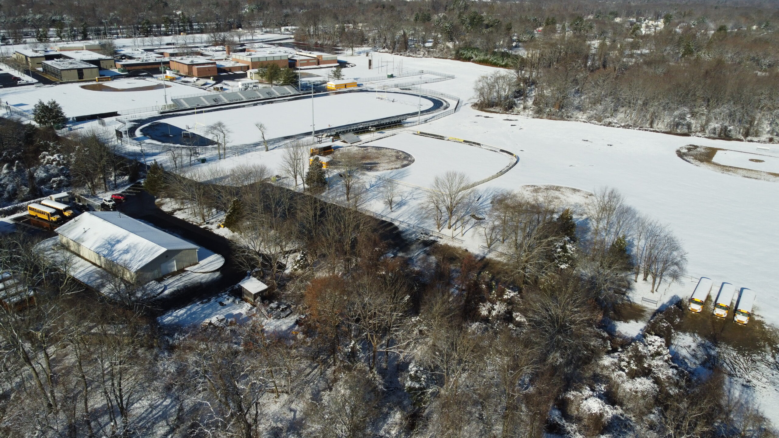
    The Jersey Shore has had more ice the past two weeks than at any point since December 2017 – January 2018. More seasonable temperatures this week melted some of that, but a full thaw won’t come soon. That gives us opportunities to enjoy the ice, as long as we keep some important safety tips in mind.

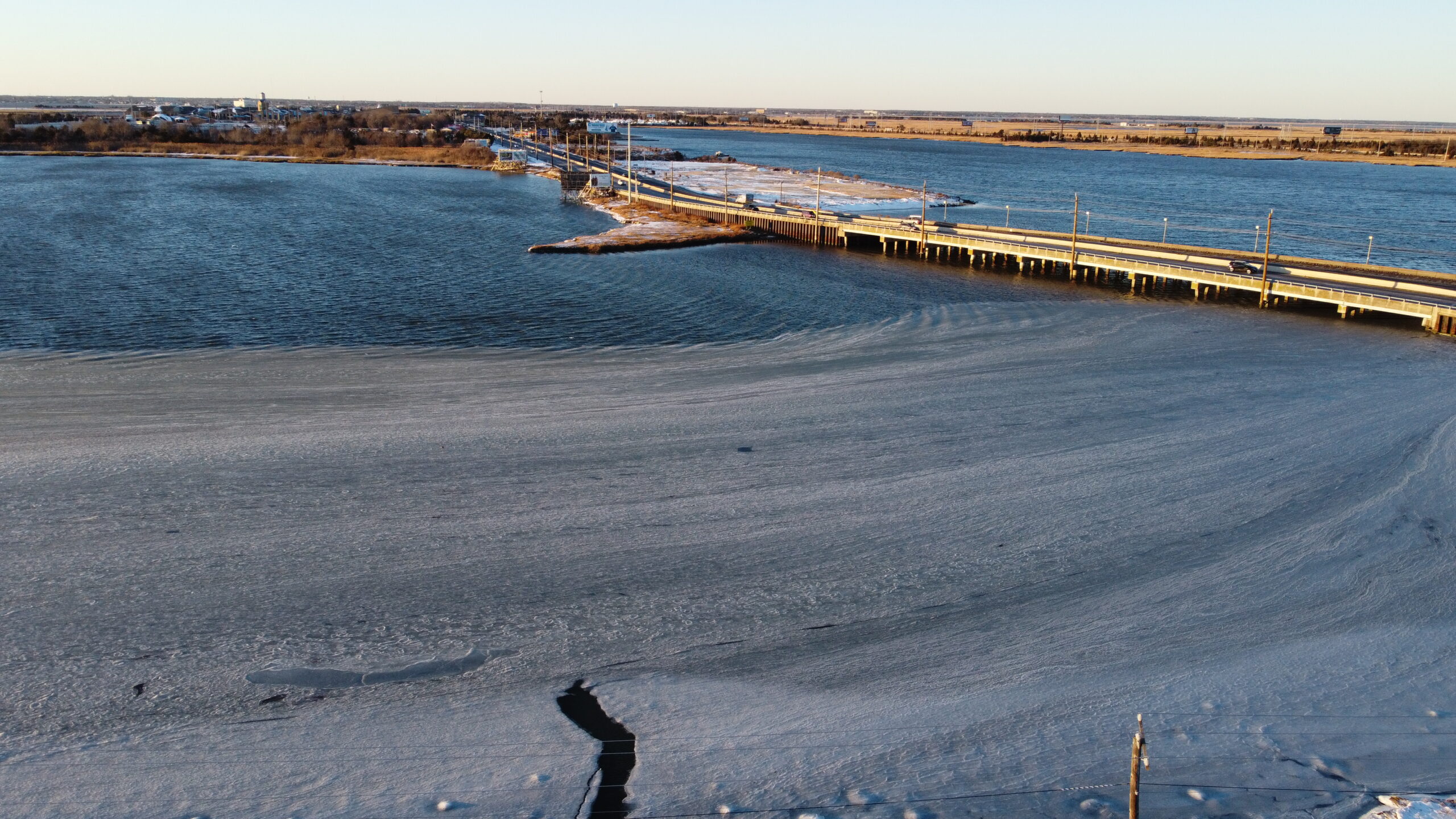
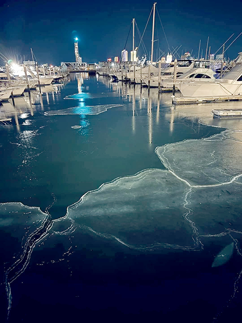
    Once Jan. 4 came, most of our days were spent below freezing. Ice first developed on the freshwater ponds in the first week of January. By Jan. 9, ice had formed on the edges of the saltwater back bays. I captured drone footage of ice on Beach Thorofare in Atlantic City, right off West End Avenue.

    That stayed more or less the same for a while. However, the arctic outbreak last week, caused by the polar vortex, expanded the ice deeper into the back bays. Big bays like the Barnegat and the Delaware, formed ice on them as well.

    Ice provides our cold, barren, Jersey Shore winter with opportunities for outdoor activities. Pond hockey, ice fishing, even just walking on the ice far away from the beaches, give us unique opportunities to enjoy our beautiful environment in a different way. However, especially in salt and tidal water, safety is paramount.

    The first step, before setting foot on the ice, is to check with your local police or fire department about ice conditions. Call their non-emergency phone number. They may even post about it on their website or social media as well.

    Photo credit: Whateveraclife Gaming

    As part of the ice report, they should list how thick the ice is. That’s important. What you can do out on the ice is determined by how thick the ice is.

    Put simply, anything below 4 inches of ice is too thin to be out on. Even your own body weight is too heavy to be supported on that ice.

    For walking, ice fishing or ice skating, ice at least 4 inches thick is mandatory, according to the Minnesota Department of Natural Resources, although if you and three friends are sitting close together ice fishing, that 4-inch ice thickness guidance is not enough, either.

    If you’re itching to take your all-terrain vehicle from the dirt roads to the ice roads, you’ll need at least 7 inches of ice to do it safely. You would struggle to find ice that thick around here. Just for reference, if you want to take a car out, you need at least 9 inches of ice.

    That’s only on new, clear ice. If snow melts then freezes on the ice to create what is called white ice, then the ice is half as strong, which means the recommended thickness should be doubled.

    For rivers, streams and especially bays, the moving water creates uneven ice. But there are ways to even out the area you’re going to utilize on the ice.

    When I used to play hockey on the Rahway River in Union County growing up, we had a pump that would throw water on the ice the day before to smooth over the bumps for the next day’s use. You don’t want to catch an edge and send yourself down to the surface.

    If you must measure the ice yourself, you’ll want an ice auger. That’s a tool with a circular, swirling shaft which, depending on the design, can be used manually or mounted to a drill to easily cut through ice. Make sure you’re standing straight up and then drill straight down. Lift it up once you cut through the ice. Then, with a tape measure, determine the thickness.

    There’s plenty of safety factors to take into consideration, but once you’re out on the ice, there’s almost nothing like it. Breathing in the icy, dry air can be invigorating. And, for a region that is tied to the water, being able to enjoy it when beach season seems far, far away is a joy.

  • Snow and bitter cold grip the Jersey Shore in January

    Snow and bitter cold grip the Jersey Shore in January

    Read it on Shore Local News here also!

    A little snow this past Sunday kicked off a week’s worth of well-below-average temperatures, which we will only get out of this Sunday.

    A coastal storm impacted the Mid-Atlantic on Sunday. This wasn’t a strong coastal storm. There was no coastal flooding, and the winds weren’t all that strong.

    However, it was still a low-pressure system that moved from the Deep South around Virginia Beach, and then just off the Nantucket coast.

    Snowfall totals at the South Jersey Shore were light. Just 0.3 inches fell in Somers Point, and a trace was reported in Ocean City.

    It snowed for several hours Sunday. However, temperatures were above freezing most of the time, which meant much of that snow melted on contact with the ground instead of accumulating.

    Other parts of the state picked up more snow. Western Atlantic County saw 1 to 2 inches, and Northern Ocean County saw about that as well with northwest New Jersey seeing 4 to 8 inches.

    I mentioned in my forecast that what happens after the storm would be more impactful than what happens during it, and surely came true.

    Temperatures crashed into the 20s, turning wet pavements and sidewalks into sheets of ice. That ice still hasn’t melted in spots as temperatures stayed below freezing Monday, Tuesday and Wednesday. At the time of this writing, it looks like temperatures were not going to go above freezing until Friday inland, perhaps just peaking at 33 degrees in the beach towns Thursday.

    Either way, it’s been frigid. Atlantic City International Airport had a high temperature of 29 degrees Monday. On Tuesday, both ACY Airport and Sen. Frank S. Farley State Marina reached just 20 degrees for the high.

    Tuesday was the coldest day since Dec. 24, 2022. It was 21-23 degrees below average – as cold as a typical Jan. 21 day in Caribou, Maine, in the far northern reaches of our northernmost state.

    Morning lows were very cold as well. However, without a snowpack to accelerate the cooling at night, it hasn’t been exceptional. Lows generally remained 7-12 degrees inland, and 10-15 degrees at the shore.

    This polar plunge was the result of the polar vortex. About two weeks ago, the polar vortex in the stratosphere, which is 8 to 31 miles above the surface, entered the Northeast, causing the jet stream in the troposphere, which is about 20,000 to 30,000 feet high, to become very wavy, moving in a more south-to-north fashion. The jet stream is the river of air that separates two air masses. In this case, it was mild air to the south and true polar air to the north.

    Once Sunday’s storm passed, that jet stream dipped down into the Gulf Coast. Since we’re far north of that, we had a near uninterrupted path to the polar air.

    Now as cold as it’s been, we didn’t break any cold temperature records. At the Atlantic City Marina, we needed to have highs in the 10s, with lows in the lower single digits. At Atlantic City International Airport, the lows needed to be below zero.

    Getting below zero is tough and getting tougher. The last time the airport was below zero was Jan. 7, 2018, according to the National Oceanic and Atmospheric Administration. It’s been three years since we last set a minimum daily temperature record. However, we’ve set roughly two dozen maximum temperature records since.

    The bitter cold will end this weekend. Temperatures will rise to seasonable levels Sunday, with highs in the 40s. It will feel like New Orleans compared to where we’ve been. However, maybe I’m speaking too soon, since that city just saw its biggest snowfall in recorded history on Tuesday.

  • Save the dates for these 12 Jersey Shore weather events

    Save the dates for these 12 Jersey Shore weather events

    Swapping the previous year’s calendar in December for the new one in January is a social construct. January is still climatological winter. The shortest day of the year, the winter solstice, was already in December and the coldest days are still ahead of us.

    In fact, in the weather world, a “water year” runs October to September. The snow year goes from July to June. Planet Earth doesn’t care about whether it’s Dec. 31 or Jan. 1.

    However, we can still pick out a few weather, climate and solar phenomena to mark your 2025 calendar for the Jersey Shore. Meteorologist Kyle David, a fellow Rutgers University graduate, and I produced this list. The list is month by month and separated between the immediate shore, using the Sen. Frank S. Farley State Marina in Atlantic City, and for mainland areas, using Atlantic City International Airport in Egg Harbor Township.

    Data is from the National Oceanic and Atmospheric Administration or https://www.timeanddate.com/. Mainland weather and climate data traces back to Aug. 1943. For the shore, that data stretches back to December 1873.

    Happy New Year and enjoy tracking the atmosphere and science throughout 2025!

    READ THE REST OF SHORE LOCAL NEWS HERE!