TUESDAY’S FORECAST | Brrrrr. That’s all I can say. Wind chills are in the teens all day long. We’re 20 degrees colder than average. An even longer polar plunge is on the way this weekend and for a long while after. Snow? Too early for that. If your personal forecast feels uncertain this winter, support is available.
See You Through It Counseling offers in-person and virtual therapy for children, adults, and couples. Invest in healing that lasts. Visit seeyouthroughitcounseling.com or call 856-335-1352.
This was a tough system. It took until my very last snowfall forecast early Sunday morning to get it to a good place. It paid off.
The highest snowfall totals were along the New Jersey Turnpike corridor. Generally, two to four inches of snow fell from Salem County, northeast to Bergen County.
Closer to the coast, inland Monmouth County also saw two to four inches of snow. Elsewhere was less. However, everywhere, even Cape May, did get a coating of snow.
Snow came to the beaches and accumulated as the mini-coastal storm pulls away from New Jersey. The big weather story tonight will be the black ice. It’ll be a skating rink if it’s not salted or brined! It’s all a part of a series of polar punches coming to our forecast.
Never worry about missing severe weather warnings again. Get a recorded call from me when your location is impacted. WeatherCall ensures you stay informed for just $15 a year. Sign up: https://ngorder.wxriskalerts.com/db_app2.php?station=cajx
5PM WEATHER UPDATE | It’s the second half of our coastal system! Rain will change over to snow at the Jersey Shore as colder air moves in. By 8PM, everywhere should be snowing. Then, it gets chillllllllly.
Never worry about missing severe weather warnings again. Get a recorded call from me when your location is impacted. WeatherCall ensures you stay informed for just $15 a year. Sign up: https://ngorder.wxriskalerts.com/db_app2.php?station=cajx
SUNDAY 1230PM UPDATE | It’s halftime of this coastal system, with not much rain or snow falling. However, the radar will fill in and expect to see a lot more snow than this morning. I have an updated look at the snow forecast and black ice to come!
Never worry about missing severe weather warnings again. Get a recorded call from me when your location is impacted. WeatherCall ensures you stay informed for just $15 a year. Sign up: https://ngorder.wxriskalerts.com/db_app2.php?station=cajx
8AM UPDATE: Anything from rain to freezing rain to snow is falling across the Jersey Shore. I bumped up my snow forecast for a small part of the area. For some of the shore, though, the BLACK ICE Sunday night is the bigger issue.
SATURDAY AM UPDATE | I can’t ignore it. It does look like the coastal storm Sunday will beat out the dry air. That means an increase in the snow forecast. That also means we have to deal with a rain/snow line, too.
Never worry about missing severe weather warnings again. Get a recorded call from me when your location is impacted. WeatherCall ensures you stay informed for just $15 a year. Sign up: https://ngorder.wxriskalerts.com/db_app2.php?station=cajx
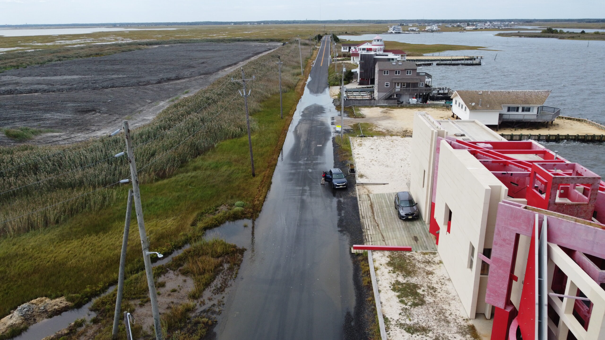
The Jersey Shore had two memorable tidal flooding events in 2025 – August’s Hurricane Erin, and an October nor’easter. New analysis shows that while tidal flooding in 2025 was generally lower than in 2023 and 2024, most of the South Jersey shoreline still flooded more than it had in decades past.
A plethora of smaller storm systems and astronomical high tide cycles also brought minor, or nuisance flooding. Despite the intensity of the flooding, the amount of coastal flooding events in 2025 saw a split, familiar to many, between North and South Jersey (I will not get into the merits of Central Jersey in this column).
Ship Bottom, 35 floods in 2025. Long-term average of 28.
Margate, 49 floods in 2025. Long-term average of 35.
Ocean City, 34 floods in 2025. Long-term average of 31.
This marks at least the third year in a row with the number of coastal flooding events above the long-term average. That average, mind you, is increasing as the number of yearly events increases.
So, why are we seeing an uptick in coastal flooding events in South Jersey?
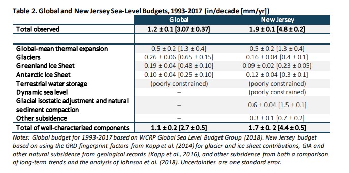
Sea level rise is a great start and is one of the key coastal flooding components. Between 1911 to 2019, New Jersey’s sea level rose at more than twice the world’s rate – and 40% of it is directly due to man-made, greenhouse gas climate change, according to the Rutgers Scientific and Technical Advisory Panel.
Sea level rise caused for the globe and New Jersey (via Rutgers Scientific and Technical Advisory Panel)
This is primarily because water expands as it gets warmer, along with glacier melt. However, this rise in sea level cannot be entirely blamed on human-caused climate change. There are other unique factors that contribute to our rapid rise in sea level compared to the rest of the world.
Most of South Jersey’s beaches are on barrier islands, surrounded by the back bays and the Atlantic Ocean. In addition, a lack of topography makes it easier for water from both sides (the ocean and the bay) to come into the streets where towns do not already protect the coastline.
With or without a storm, many of these communities experience some degree of coastal flooding monthly during astronomical high tide cycles. Given that, any storm system traveling along or up the coast will only worsen flooding, especially during high tide. Thus, barrier island beaches are the biggest victims of coastal flooding.
This depletion of water from the aquifer has caused the ground above it to sink. As a result, decreasing elevation levels are magnifying sea-level rise, making the Jersey Shore more susceptible to coastal flooding.
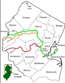
Furthermore, there’s glacial rebound. From roughly 25,000 to 18,000 years ago, a glacier went as far south as present-day Raritan River in North Jersey. The glacier is long gone, however the land is still shifting around from that glacier retreat. That’s also elevating sea levels.
Southward extent of NJ glaciers from 25,000 to 18,000 years ago.
The opposite is true for the northern Jersey Shore beaches. From Sandy Hook to Ship Bottom, tidal flooding was lower than average. Regardless, coastal flooding still brought its fair share of impacts to some of Monmouth and Ocean counties’ most vulnerable spots.
Year-to-year fluctuations in the number of coastal flooding events are to be expected at specific shore locations. Yet, looking at the Jersey Shore as a whole, one cannot deny the upward trend in coastal flooding events, and the reasons behind them.
As for this year, there has been no tidal flooding yet. Let’s hope it stays that way for a while.
FRIDAY’S FORECAST: I’m not in love with it but my first call snow forecast for Sunday’s (1/18) system is here. It’s a matter of snow vs. no snow, not rain vs. snow. There’s also a little wintry weather on Saturday, too. Tune in for your (very cold) 7-day forecast!
THURSDAY PM UPDATE | The computer weather models are converging on a snowy solution for New Jersey on Sunday, 1/18. However, with a big, dry area of high pressure dominating the Northeast before, I just can’t fully buy it yet.
Embark on your next adventure with Travel with Donna, the shore’s premier full-service travel agency! This female-owned local gem is your ultimate travel guru. Reach out at Donna@TravelwithDonna.VIP or text 609-287-2870.