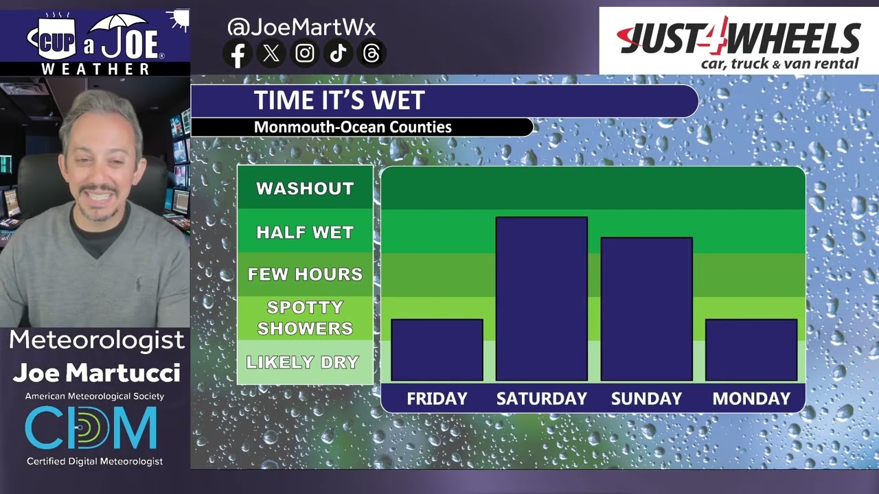
THURSDAY’S FORECAST | Temperatures are 20 to 30F cooler today than they were yesterday. Such is like near Memorial Day Weekend. Much needed rain comes for MDW, that’s the silver lining. I do NOT believe it’s a full washout, though. It even gets warm! Let’s talk.
Why settle for big chains? Choose Just4Wheels’ family-owned locations all across NJ! Rent brand-new sedans, passenger vans, box trucks and more today! Visit www.just4wheels.com or call 877-650-3500.
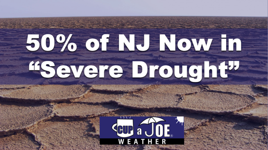
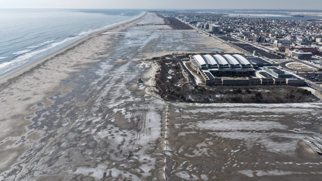
A “severe” drought (level 2/4) drought now engulfs 50% of New Jersey, including most of the Jersey Shore, according to the United States Drought Monitor on May 14. That’s 30% increase from last week.
The NJ Department of Environmental Protection put the state in a drought warning in November. However, if widespread, soaking rain does not come in the next month, mandatory water restrictions would be possible. That comment comes from State Climatologist Dr. Dave Robinson from our Monthly Weather Roundup show on May 5.
Drought continues for the sixth month in a row in New Jersey, according to the state’s Department of Environmental Protection. Now, though, other indicators are showing warning signs of a crippling drought, too.
Believe it or not, April was in the top 10 for warmest Aprils since records started in 1895. That’s true even though April 21 brought a killing freeze to most of New Jersey only seen once or twice a decade.
Recap the month of weather that was. It’s all Jersey, with two of Jersey’s best weather guys. New Jersey State Climatologist Dr. Dave Robinson as well as Meteorologist Joe Martucci, owner of Cup A Joe Weather and Drone, take you through it all.
When I talk about this in my weather videos, or post about it on social media, some variation of the same question comes up.
“How could the Jersey Shore be in drought? We had so much snow last winter.”
While yes, we did have well-above-average snowfall (26.1 inches at Atlantic City International Airport, 18.6 inches in Margate, and 39.2 inches in Long Branch), but lots of snow doesn’t necessarily cure a drought. The correlation is pretty weak.
Drought is defined as “a period of abnormally dry weather sufficiently long enough to cause a serious hydrological imbalance,” according to the American Meteorological Society. In other words, if the water going into the environment is less than the water being taken out of the environment (by humans, animals, evaporation, etc.) for a long period of time, you go into drought.
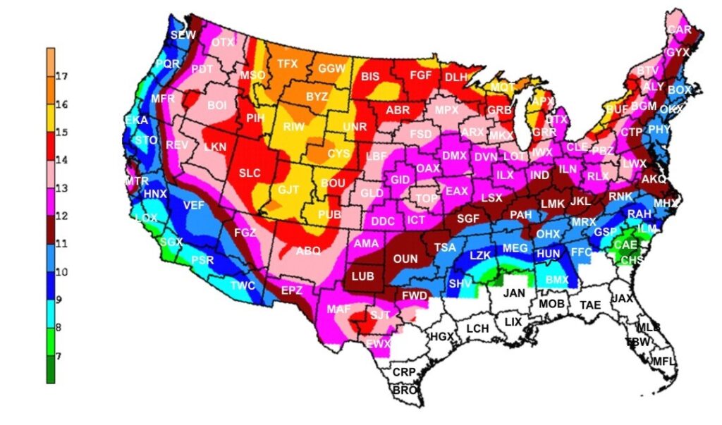
Water comes into the environment by precipitation. Snow is precipitation, so is rain. However, on average in New Jersey, it takes 11 inches of snow to get 1 inch of precipitation. Meanwhile, 1 inch of rain equals 1 inch of precipitation.
Snow to liquid ratio climatology. On average for New Jersey, it takes 10 to 11 inches of snow to produce one inch of precipitation. (via the National Weather Service)
Here’s a look at how much snow, precipitation and average precipitation fell at Atlantic City International Airport from December to February:
In December, there were 2.2 inches of snow, 3.03 inches of precipitation, vs. 3.76 inches of average precipitation.
January saw 6.7 inches of snow, 3.78 inches of precipitation, vs. 3.44 inches of average precipitation.
February recorded 17.2 inches of snow, 3.53 inches of precipitation, vs. 3.12 inches of average precipitation.
Snowfall was about 75% above average during this time. Precipitation was about 5% below average.
What about the snowpack?
This winter probably felt extra long because the snow was on the ground for so long. Twenty-nine days had at least 1 inch of snow covering the ground at Atlantic City International Airport, according to the National Oceanic and Atmospheric Administration, the sixth longest since records began in 1945.
default
Snow on the ground helps prevent drought from worsening. It allows for snow to slowly melt and seep into the ground. It also prevents the sun from pulling water from the ground and evaporating into the atmosphere.
However, the snowpack wasn’t deep enough nor did it hang around long enough to have a significant impact on the drought.
All things considered, it was a lack of precipitation in March that slid the Jersey Shore into a deeper drought.
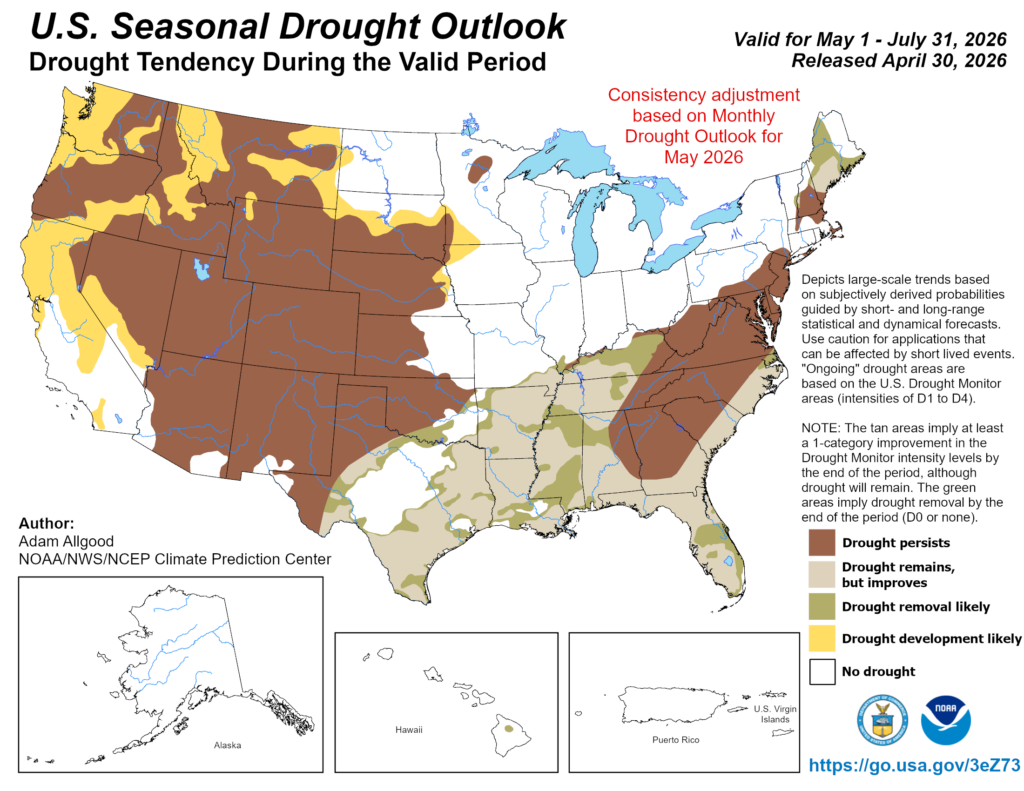
Drought outlook for NJ
NOAA is forecasting that drought conditions will persist through the end of July, according to its April 30 update.
Precipitation across the Jersey Shore, not just in a town or two, needs to average at least 5 inches during this time in order to drown out the drought. More than 4 inches of evaporation occurs during June and July.
We’ll need a few coastal storms, or a very gloomy next month or two, in order to do that. If not, don’t be surprised to see mandatory water restrictions by the end of the summer.
After 3 straight months with colder than average temperatures, March winds up not just warm, but in the top 20 warmest going back to 1895! One thing that didn’t change was precipitation. The Jersey Shore wound up much drier than average and NJ State Climatologist Dr. Dave Robinson is concerned about wildfire season.
Recap the month of weather that was. It’s all Jersey, with two of Jersey’s best weather guys. New Jersey State Climatologist Dr. Dave Robinson as well as Meteorologist Joe Martucci, owner of Cup A Joe Weather and Drone take you through the temperatures, rain, snow, coastal flooding and much more every episode.
New episodes come out the beginning of every month.
FRIDAY’S FORECAST | We go from the 60s this morning to the 40s this afternoon! A nationwide cold front will sag through the Jersey Shore, which is bringing the rain. This weekend has plenty of strong March sun but it’ll be chilly. Let’s talk!
Join us as we review the intense winter weather in New Jersey, including record snowfalls, blizzards, and drought conditions, with State Climatologist Dr. Dave Robinson. Discover the details behind the storms, snowpack, and what to expect in the coming months.
00:00 Introduction to February Weather Roundup 02:00 The February Nor’easter: Impact and Analysis 12:05 Snowpack and Its Effects on Weather Patterns 17:00 Winter Overview: Cold and Snowy Trends 22:55 Drought Conditions and Future Predictions 24:30 It was cold this winter, but…
Recap the month of weather that was. It’s all Jersey, with two of Jersey’s best weather guys. New Jersey State Climatologist Dr. Dave Robinson as well as Meteorologist Joe Martucci, owner of Cup A Joe Weather and Drone take you through the temperatures, rain, snow, coastal flooding and much more every episode. New episodes come out the beginning of every month.
THURSDAY’S FORECAST | Forget about Dry January, we’re living in Dry February across the Jersey Shore! We’ve seen near 0″ of precipitation this month. That’ll change late this weekend and if you’re a snow lover, there is a path toward the white stuff falling!
Our 24×7 Jersey Shore Weather Channel: https://www.youtube.com/watch?v=lGssDGu6xk0
On Dec. 5, the New Jersey Department of Environmental Protection (NJDEP) issued a drought warning for the state. It brings back not-so-distant memories of barely flowing streams and record dry weather. However, unlike the previous drought warning, Jersey Shore fares the best in the state this time around.
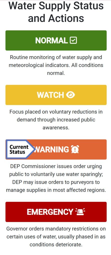
A drought warning is not an emergency yet — it’s an early step to manage water supplies when a drought is starting to happen. It comes after a drought watch, but before a full drought emergency. The main goal of a drought warning is to stop things from getting so bad that the state must declare a real water emergency.
Via the NJDEP
“All New Jerseyans are requested to follow water conservation practices, and to use water wisely, particularly when using water outdoors,” the NJDEP wrote in their statement.
To be clear, there are no state mandatory water restrictions in place. That can only be issued if the governor declares a drought emergency. However, like we saw with New Jersey American Water last fall, water companies can issue their own restrictions to users.
The last drought warning was in effect from November 2024 to June 2025. That came just after the driest autumn on record for New Jersey. Even after June, the NJDEP still had Atlantic and Cape May counties on a drought watch, to increase our awareness of the impact on our water supply.
In the previous drought warning, the Jersey Shore had the most severely dry conditions. This time though, the coast is making out better than our friends to the west and north.
The United States Drought Monitor, which is unaffiliated with the NJDEP, issues drought updates every Thursday, using data from the previous Tuesday.
As of Dec. 4, the most recent update at the time of this writing, Cape May County, from Sea Isle City to Dennis on south, is in the first stage of drought, called “moderate drought.” The rest of the Jersey Shore is completely drought-free, though. Data shows that 55% of New Jersey is in drought, though.
Most of that is on the Delaware Bayshore and then roughly the New Jersey Turnpike northwest. About 10% of the state is in the second level of drought, known as severe drought. That’s mainly in Sussex, Salem and Cumberland counties.
The drought monitor looks mainly at the precipitation, soil, rivers and plants. Meanwhile, the NJDEP focuses on reservoirs and drinking water. Both are useful tools, though we in New Jersey will act based on the NJDEP, not the drought monitor.
Either way, both agree that the Jersey Shore is least impacted by drought.
Then came November. It was drier than average. Cape May and Atlantic counties picked up between 1 to 2.25 inches of precipitation. The average for November is 3.37 inches at Atlantic City International Airport, and 3.44 inches at Sen. Frank S. Farley Marina in Atlantic City, according to the National Oceanic and Atmospheric Administration. So, it was dry.
It was even drier than average in the north. November in Boonton (Morris County) and Belvidere (Warren County) were among the driest 20% on record.
At the same time, the shore continues to pick up the most from whatever rainmakers we get. On Dec. 2, over an inch fell in Egg Harbor Township, Cape May Court House and Atlantic City. Much of Northwest New Jersey had less than a half inch.
However, we need to look at more than just what’s happened recently to get a picture of our drought situation. Drought usually is long term, occurring over multiple years. We’re probably in the middle of one. We’ll improve at times, but the ground in New Jersey is dry and has been dry for at least a year. A wetter month here and there is good. A months-long, sustained period of ample rain and snow is needed to buck this trend, though.
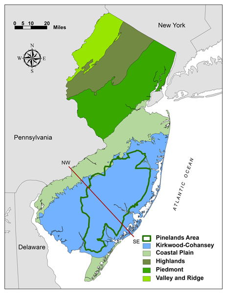
Groundwater levels and stream flows over the past 90 days are “extremely dry” in the Coastal South region, according to the NJDEP’s Dec. 7 update. That’s roughly Toms River to Seaside Heights on south. It’s been this way for multiple weeks. We rely on groundwater from the Kirkwood-Cohansey aquifer for our freshwater needs.
The location of the Kirkwood-Cohansey aquafer in blue, within New Jersey (via the state of New Jersey)
There was improvement during the summer, but we haven’t been “near or above normal” in at least a year.
Like last year, having a drought during the cool season is better than having one during the warm season. Sprinklers are turned off, pools and water parks are closed and water usage is just less. Moreover, the sun is weak and doesn’t evaporate as much water as in the summer.
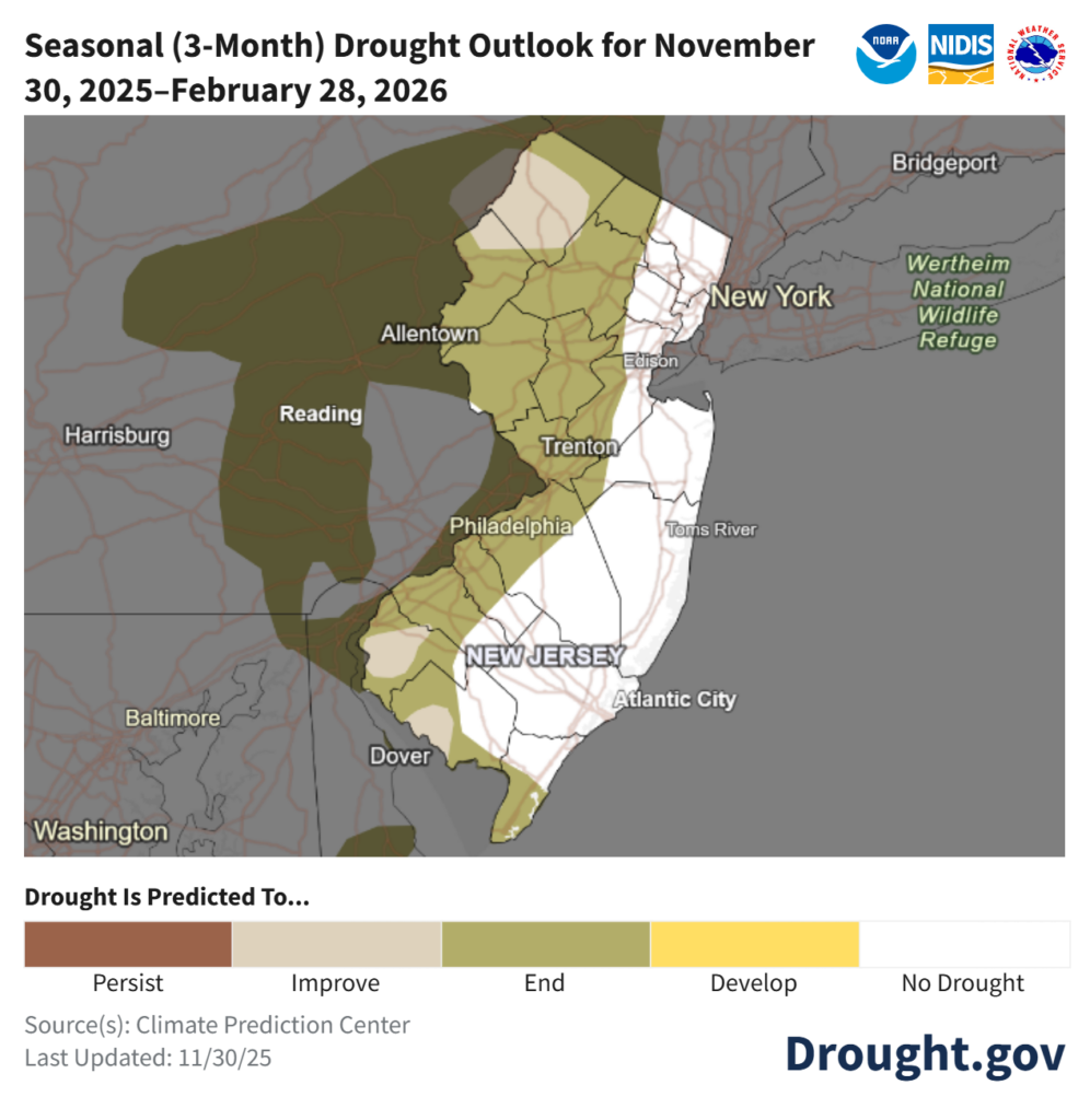
So, does that give us enough runway to pull out of this drought? NOAA believes so. For the areas the US Drought Monitor has in a drought now, an improvement is expected over the winter according to their Nov. 30 update. For December, there is a lean toward a wetter (perhaps whiter) than average month.
For now, reduce water usage where you can. It’s not as big of a problem as last winter. This will be monitored closely.
Joe Martucci, a Certified Broadcast Meteorologist and Digital Meteorologist, is the President and Director of Meteorology for Cup A Joe Weather and Drone. You can connect with him at cupajoe.sparkable.opalstacked.com/.


