Tag: drought

  • NJ is back in a Drought Warning, but it never really left

    NJ is back in a Drought Warning, but it never really left

    On Dec. 5, the New Jersey Department of Environmental Protection (NJDEP) issued a drought warning for the state. It brings back not-so-distant memories of barely flowing streams and record dry weather. However, unlike the previous drought warning, Jersey Shore fares the best in the state this time around.

    A drought warning is not an emergency yet — it’s an early step to manage water supplies when a drought is starting to happen. It comes after a drought watch, but before a full drought emergency. The main goal of a drought warning is to stop things from getting so bad that the state must declare a real water emergency.
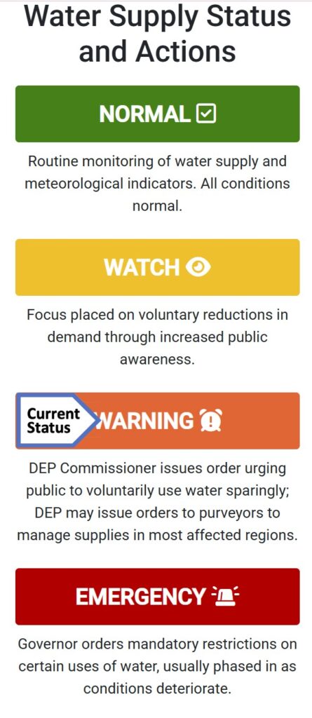
    Via the NJDEP

    “All New Jerseyans are requested to follow water conservation practices, and to use water wisely, particularly when using water outdoors,” the NJDEP wrote in their statement.

    To be clear, there are no state mandatory water restrictions in place. That can only be issued if the governor declares a drought emergency. However, like we saw with New Jersey American Water last fall, water companies can issue their own restrictions to users.

    The last drought warning was in effect from November 2024 to June 2025. That came just after the driest autumn on record for New Jersey. Even after June, the NJDEP still had Atlantic and Cape May counties on a drought watch, to increase our awareness of the impact on our water supply.

    In the previous drought warning, the Jersey Shore had the most severely dry conditions. This time though, the coast is making out better than our friends to the west and north.

    The United States Drought Monitor, which is unaffiliated with the NJDEP, issues drought updates every Thursday, using data from the previous Tuesday.

    As of Dec. 4, the most recent update at the time of this writing, Cape May County, from Sea Isle City to Dennis on south, is in the first stage of drought, called “moderate drought.” The rest of the Jersey Shore is completely drought-free, though. Data shows that 55% of New Jersey is in drought, though.

    Most of that is on the Delaware Bayshore and then roughly the New Jersey Turnpike northwest. About 10% of the state is in the second level of drought, known as severe drought. That’s mainly in Sussex, Salem and Cumberland counties.

    The drought monitor looks mainly at the precipitation, soil, rivers and plants. Meanwhile, the NJDEP focuses on reservoirs and drinking water. Both are useful tools, though we in New Jersey will act based on the NJDEP, not the drought monitor.

    Either way, both agree that the Jersey Shore is least impacted by drought.

    The simplest answer to our improved circumstances here is the rain. The Jersey Shore climate region, generally east of the Garden State Parkway, had the most among the Office of the New Jersey State Climatologist’s three state climate regions since drought ended in June until October.

    Coast – 18.21 inches

    South – 16.71 inches

    North – 16.22 inches

    Then came November. It was drier than average. Cape May and Atlantic counties picked up between 1 to 2.25 inches of precipitation. The average for November is 3.37 inches at Atlantic City International Airport, and 3.44 inches at Sen. Frank S. Farley Marina in Atlantic City, according to the National Oceanic and Atmospheric Administration. So, it was dry.

    It was even drier than average in the north. November in Boonton (Morris County) and Belvidere (Warren County) were among the driest 20% on record.

    At the same time, the shore continues to pick up the most from whatever rainmakers we get. On Dec. 2, over an inch fell in Egg Harbor Township, Cape May Court House and Atlantic City. Much of Northwest New Jersey had less than a half inch.

    However, we need to look at more than just what’s happened recently to get a picture of our drought situation. Drought usually is long term, occurring over multiple years. We’re probably in the middle of one. We’ll improve at times, but the ground in New Jersey is dry and has been dry for at least a year. A wetter month here and there is good. A months-long, sustained period of ample rain and snow is needed to buck this trend, though.

    Groundwater levels and stream flows over the past 90 days are “extremely dry” in the Coastal South region, according to the NJDEP’s Dec. 7 update. That’s roughly Toms River to Seaside Heights on south. It’s been this way for multiple weeks. We rely on groundwater from the Kirkwood-Cohansey aquifer for our freshwater needs.
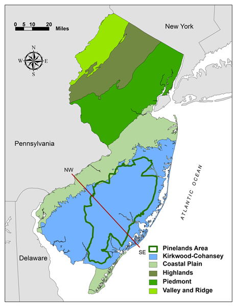
    The location of the Kirkwood-Cohansey aquafer in blue, within New Jersey (via the state of New Jersey)

    There was improvement during the summer, but we haven’t been “near or above normal” in at least a year.

    Like last year, having a drought during the cool season is better than having one during the warm season. Sprinklers are turned off, pools and water parks are closed and water usage is just less. Moreover, the sun is weak and doesn’t evaporate as much water as in the summer.

    So, does that give us enough runway to pull out of this drought? NOAA believes so. For the areas the US Drought Monitor has in a drought now, an improvement is expected over the winter according to their Nov. 30 update. For December, there is a lean toward a wetter (perhaps whiter) than average month.
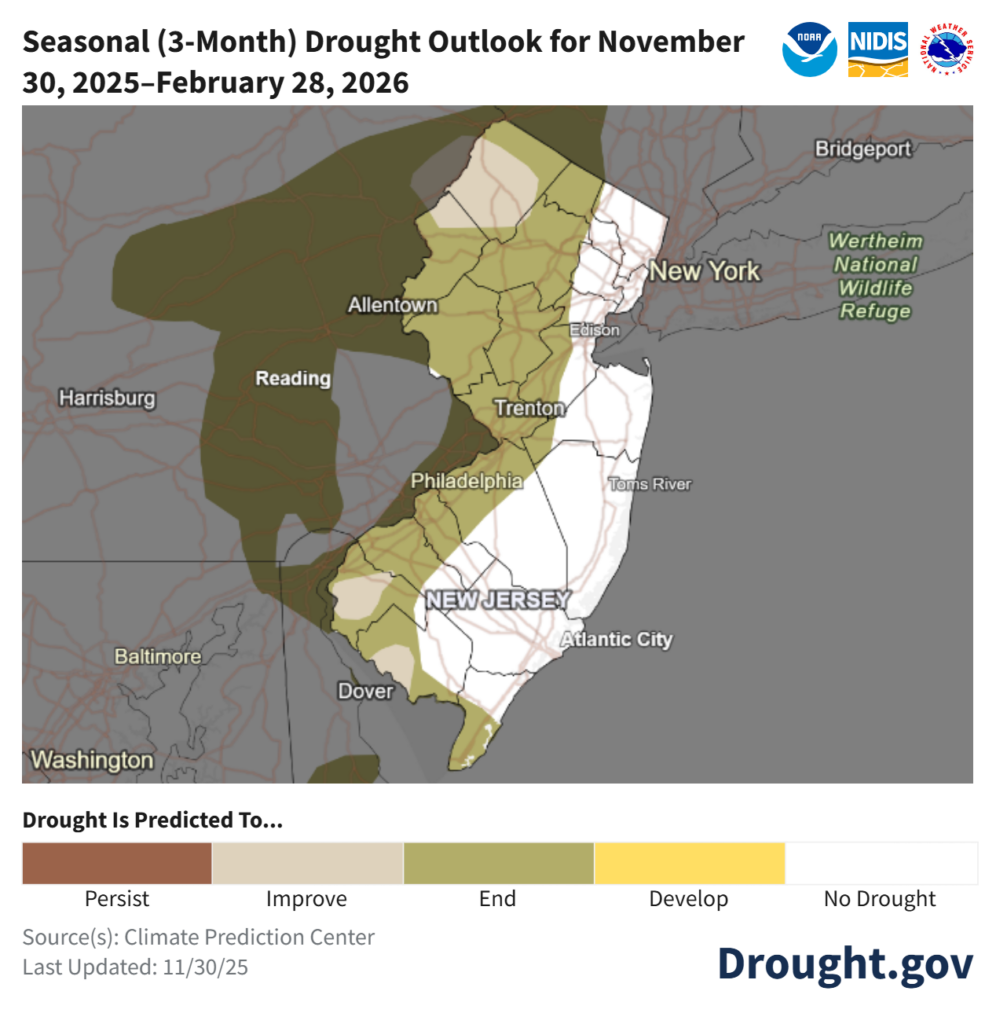
    For now, reduce water usage where you can. It’s not as big of a problem as last winter. This will be monitored closely.

    Joe Martucci, a Certified Broadcast Meteorologist and Digital Meteorologist, is the President and Director of Meteorology for Cup A Joe Weather and Drone. You can connect with him at cupajoe.sparkable.opalstacked.com/.

  • NJ’s drought improves but path to drought-free will get tougher

    NJ’s drought improves but path to drought-free will get tougher

    By Meteorologist Joe Martucci

    This article ran in Shore Local Magazine on March 27th. The original article had data through March 21 (read here). However, this version is updated to the 27th.

    Mother Nature has made up for lost time, bringing plentiful rain to the state since March 5. That’s led to three consecutive weeks of improved drought status, according to the United States Drought Monitor.

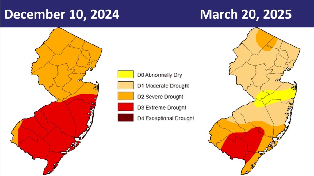
    The improved status is clearly visible in the latest update (dated March 20) from the United States Drought Monitor.

    From New Year’s Day through March 4, 3.81 inches of rain fell at Atlantic City International Airport in Egg Harbor Township. The report came from the National Oceanic and Atmospheric Administration. From March 5 until March 21, 5.55 inches of precipitation fell.

    The Sen. Frank S. Farley State Marina in Atlantic City saw a similar increase, recording 5.21 inches of precipitation March 5-21. Before that, it was 3.44 inches since the year began.

    It’s not just Atlantic County. Longtime weather reporting stations in Long Branch (Monmouth County), Trenton (Mercer County), and Philadelphia all saw as much or more precipitation since March 5. This is compared to the previous 64 days of the year.

    The weather pattern favors more storminess through the first week of April. So the shore should continue to see steady or improved drought status. However, improvement for the rest of the spring is considered unlikely. We will say more about that in the moment.

    On March 20 the South Jersey shoreline, from Stafford Township and Long Beach Island on south, improved from extreme drought. This was a level three of four drought. It improved to a severe drought, which is a level two of four. That’s our lowest level since Nov. 5, 2024.

    Inland Atlantic County (west of the Garden State Parkway), was still in extreme drought, though. Those areas join most of Cumberland County, and a small portion of inland Cape May County. This is the only area east of the Mississippi River in significant drought, as my friend and New Jersey State Climatologist Dave Robinson texted me last week.

    Still, New Jersey’s drought is improving. The 7% of the state in extreme drought is the lowest since Oct. 29, when the state was in the midst of its historic driest month on record.

    Drought status between December 10, the peak of the drought, and March 20, in New Jersey (United States Drought Monitor)

    The waning days of March, and the beginning of April bring plenty of opportunities to improve drought even more.

    The Climate Prediction Center, part of NOAA, gives a lean toward wetter conditions around our area through April 4. That’s because the jet stream – the river of air about 30,000 feet high – will be over or around New Jersey during this time. Think of the jet stream as the storm track, with a colder air mass to the north and warmer air mass to the south. This is in part a reaction to the polar vortex entering the Northeast last week, which I talked about on social media if you follow me there.

    We’ll take what we can get. In March, 0.75 inches of rain a week generally keeps us from slipping further into drought. Over an inch, like we’ve seen for most of March, will improve drought’s status.

    However, once we go into April, water usage increases. The sun evaporates more water out of the ground as it goes higher in the sky. We’ll need an inch per week just to keep up, with over 1.25 inches a week to improve drought. These need to be region-wide soakers, too.

    Sure, 3 inches of rain in Linwood from pop-up thunderstorms is great. However, in order for the Kirkwood-Cohansey Aquifer, from which southeastern New Jersey gets its drinking water, and reservoirs for the rest of the state to recharge, we’ll need rain from a coastal storm or a large inland low-pressure system.

    As of March 25, levels in the Manasquan Reservoir were at about 84% of capacity, according to the New Jersey Water Supply Authority. Typically, 97% is the average for March, according to the agency.

    The underlying data still shows there’s work to be done. As of March 23, average stream flows over the past 90 days are still in the “extremely dry” category up and down the Jersey Shore. In the southern part of the shore, it’s been this way for 23-straight weeks.

    I took a deep dive into the Climate Prediction Center’s outlooks. They break it down into three-month periods.

    The way I read it is I should expect a more humid-than-usual summer. That will at least increase the probability of pop-up thunderstorms. That’s good news, but again, we’ll need widespread rainmakers, which are unlikely in our climate once we hit mid-June. Rain storms from tropical cyclones don’t make their way here until late July, usually.

    In a bit of good news, there is a small lean toward wetter weather than usual here. A remnant storm or two would do wonders for us. We failed to get any last fall, which led us into this drought anyway.

    In my opinion, the best case scenario is that drought doesn’t worsen over the next few months. Then we get a tropical cyclone or two to pull us back to normal.

    The worst-case scenario: The extreme drought (level three) expands back to the Jersey Shore. The state would seriously need to consider their first drought emergency since 2002, and the mandatory drought restrictions that come with it, later in the spring.

    The NJDEP issued a statewide drought warning last November which called for voluntary water restrictions.