FRIDAY’S FORECAST | I’ll tell you how wet I see this weekend being! Honestly, it has more bark than bite. Sure it’ll be gloomy and gray but it won’t be a straight up soaker. Let’s talk about it.
📹THURSDAY’S FORECAST | It’s another gloroiously sunny day today! It gets more unsettled for the weekend. However, you will have boat and beach time outside. I’ll tell ya when!
Why settle for big chains? Choose Just4Wheels’ family-owned locations all across NJ! Rent brand-new sedans, passenger vans, box trucks and more today! Visit www.just4wheels.com or call 877-650-3500.
WEDNESDAY’S FORECAST | Sun, sun and more sun! It almost feels like September with the crisp air around. I recap your much needed rainfall totals from the past two days and break down just how wet the weekend will be.
TUESDAY’S FORECAST | More *much-needed* rain falls today, even in Cape May County where the bubble was in full force. Once then clears, we got a 2 day stretch of sunshine. We also have your (very) early 4th of July weekend forecast.
Tired of water in your basement or crawlspace? Trust Finally Dry Waterproofing’s family-owned company to fix it right. We install permanent drainage solutions guaranteed for 2 ownerships with no limit! Get your FREE inspection at finallydrywaterproofing.net.
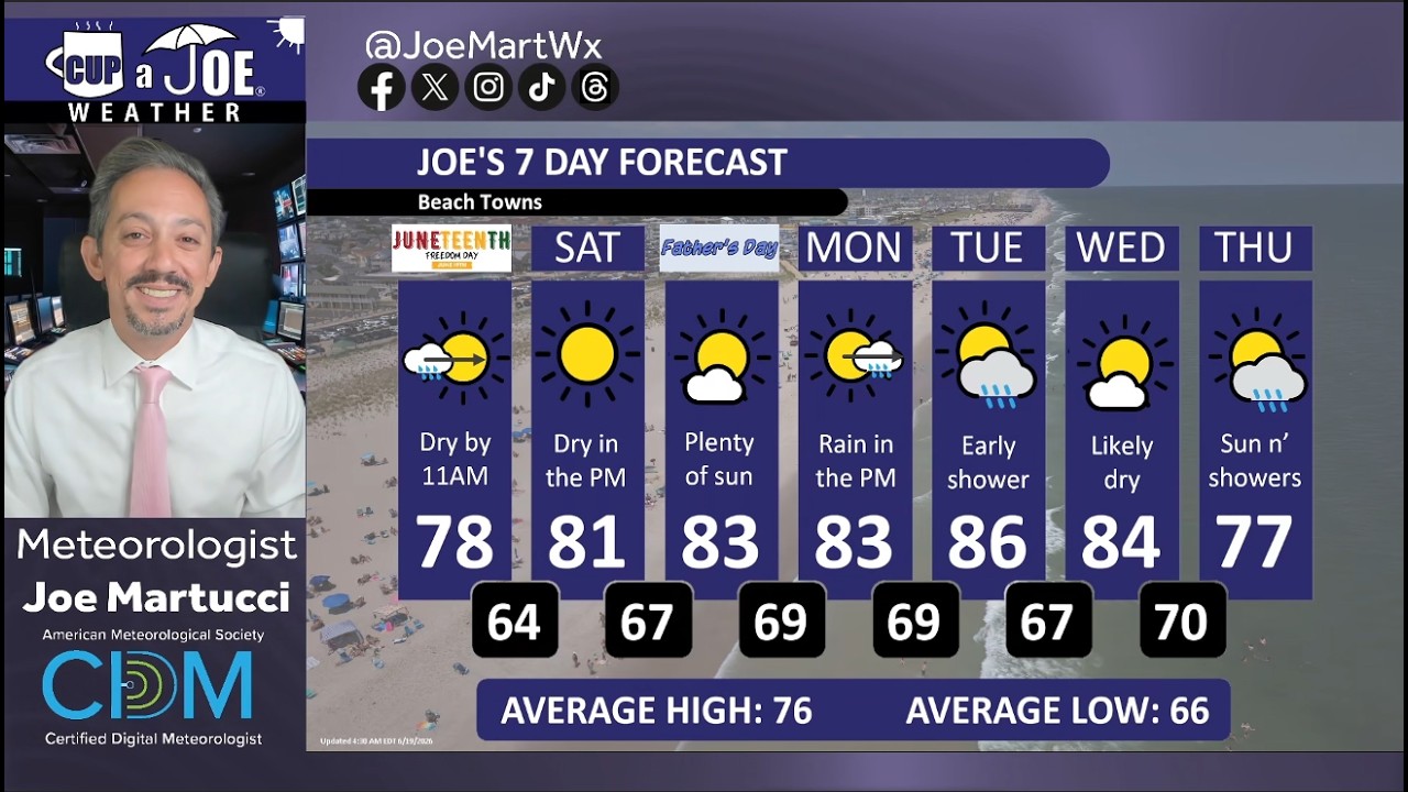
🌞SATURDAY’S FORECAST | Spectular! Sunstatic! Those are the ways to describe our Fathers’ Day weekend. Enjoy it! A storm does come Monday – Tuesday but I don’t think it’ll do a lot to quell drought.
Come visit Headley Family Farm at 120 Province Road in West Creek! It’s where farming the pines meets the Jersey Shore. Get your Jersey Fresh produce here. Open weekends and some weekdays. Call us at 609-848-3763 or follow us on Facebook, too!
FRIDAY’S FORECAST | Clouds and a few showers LBI on south this morning is the only thing separating us from an A+ weather weekend! We also have some stats for you on that crazy wind Thursday.
Stream our 24×7 Jersey Shore Weather Channel: https://www.youtube.com/watch?v=dcPpb_VycOM
Jolt your brand with the Shore’s top weather media company. Advertise today! joe@cupajoe.live
Starting Juneteenth/Fathers’ Day weekend, Sublime, Brantley Gilbert, the B-52s, Little Steven and more will keep you dancing and singing and we want you to be there.
Artist rendering of the ParkStage at the East Freehold Showgrounds.
We’re giving away 2 tickets to nearly every show. You just have to follow ParkStage and myself on social media, tag a friend and drop your email address to have your chance at winning.
The ParkStage season starts off with three concerts June 19-21. The weather couldn’t be better for all three! Expect dry weather and temperatures in the 70s all evening long.
Shoutout to the Monmouth County Commissioners for supporting the arts and this fantastic new summer venue.
🌬️THURSDAY’S FORECAST | It’s not supposed to be windy like this in June! Strong gusts in the 30s hit this afternoon, but morning clouds and showers are lowering our severe risk. Good news!
Why settle for big chains? Choose Just4Wheels’ family-owned locations all across NJ! Rent brand-new sedans, passenger vans, box trucks and more today! Visit www.just4wheels.com or call 877-650-3500.
WEDNESDAY’S FORECAST | Up to an hour of rain is the only thing between us and a gorgeous summer Wednesday. However, an unusually windy summer day comes Thursday. Another risk of severe weather arrives too but whether or not we stay safe depends on 1 thing.
A mobile friendly website, tropical alerts inland from the coast, more clarification on what could be and what won’t be a tropical system an updated forecast cone and a major experimental change highlight the updated from the National Hurricane Center (NHC) in 2026.
Every year, the National Hurricane Center rolls out a new list of operational (for official use) and experimental (for unofficial use) products and service.
Some years, the updates are important, but technical. You won’t care unless you’re a Meteorologist or real weather-weenie.
This year, though, the updates are visible, impactful and possibly paradigm changing.
Let’s go through them, in no particular order.
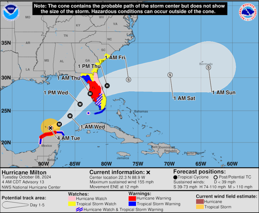
Inland tropical storm and hurricane alerts on the cone graphic are operational
What started as an experiment in 2024 passed the public opinion and internal National Hurricane Center tests. Now, it’s for official use.
When a tropical storm watch or warning, as well as a hurricane watch or warning is issued for a county inland of the coast (in New Jersey, think Mercer County) that will be shown on the forecast cone graphic.
Before, if an inland county was in a hurricane or tropical storm alert, the graphic would not show it. Only a line corresponding with the color of the alert would be shown on the coastline. For example, a red line to denote a hurricane warning along the West Coast of Florida.
The tropical forecast cone, the National Hurricane Center’s most popular tool, now will show tropical storm and hurricane alerts for inland counties. Before, only coastal county alerts were shown, even if inland counties were in an alert, too (via National Hurricane Center).
“Recommendations from social science research suggest that the addition of inland watches and warnings to the cone graphic helps communicate wind risk during tropical cyclone events while not overcomplicating the graphic with too many data layers,” the NHC said about it.
You can see the forecast cone by going to hurricanes.gov and clicking on the storm you’re interested in.
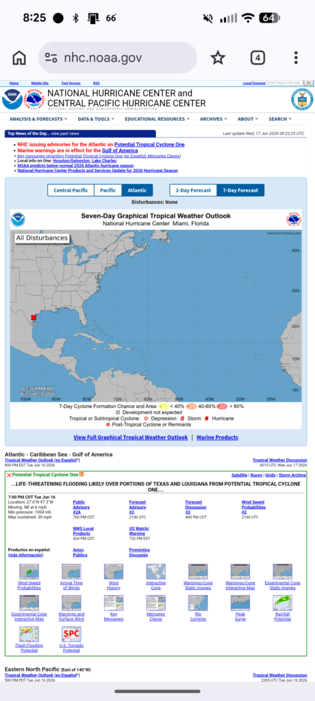
The NHC gets a long overdue mobile page
It’s not really the NHC’s fault, nor its parent organization, the National Oceanic and Atmospheric Administration’s (NOAA), for a lack of mobile device infrastructure (here’s a deep dive into why this is). However, the lack of a mobile site did make communication weather threats from America’s official source did complicate matters.
Right at the top, you will see information on active tropical systems. Below that is the Graphical Tropical Weather Outlook for any of the three hurricane basins the NHC tracks (Central Pacific, Pacific and Atlantic) as well as at 2- and 7-day outlooks.
All the way at the bottom are a collection of short-form, vertical videos they title “Building Your Hurricane Knowledge Kit”. This really brings the NHC into the 2020s, and beyond, asserting themselves as the official agency for hurricane information.
The top half of the new National Hurricane Center mobile site.
Storms with no chance of turning into a tropical system are separated out
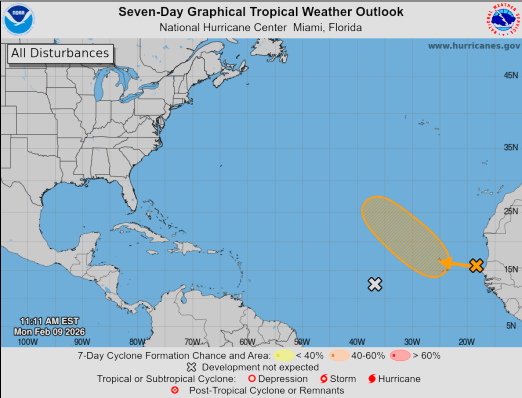
Before this year, the Graphical Tropical Weather Outlook showed all systems with a low chance of turning into a tropical cyclone as a yellow X. That even meant low pressure systems with a 0% chance.
That changes in 2026. Systems with a near 0% chance of development in the 2-day period will be marked with a gray X.
If the storm has a near 0% chance of development in the next 2-days but has a higher chance in the next 7-day, it will still be marked with a yellow X. On desktop, you’ll be able to hover over any X to see more information on it, including its chances for development in the next 2 or 7 days.
This is an example of a 7-day tropical weather map. It shows a gray X. The gray X means there is almost no chance (near 0%) that the weather system will grow into a tropical storm or hurricane in the next 2 days or in the next 7 days. (via National Hurricane Center)
This increases the communication ability of the NHC. Now, people won’t be misled about which systems can strengthen into a tropical system.
The forecast track cone gets even more accurate
The size of the forecast track cone, also known as the cone of uncertainty to some, continues to get smaller.
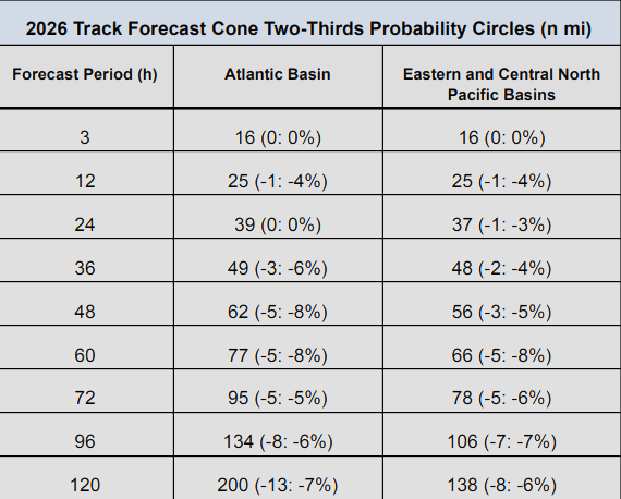
In the Atlantic Hurricane Basin, the size of the cone is up to 8% smaller (at 48 and 60 hours out from when the forecast was made). The cone also gets smaller at hours 12, 36, 72, 96 and 120.
The Pacific Hurricane Basin saw decreases up to 8% as well.
2026 track forecast cone sizes at different hours out from the initial forecast. (National Hurricane Center).
Even the forecast cone being 13 nautical miles smaller, like it is at hour 120 can be the difference between a small county like Union County, NJ being in a tropical storm watch, or nothing at all.
The NHC determines the size of the cone by looking at the average of the forecast errors over the previous five years. The 2026 cone continues the near annual tradition of decreases in the size of the cone.
Tomorrow marks 20 years since Hurricane Katrina hit New Orleans. Brian McNoldy (@bmcnoldy.bsky.social) has a great visualization showing how much forecasts have improved over two decades: Purple = actual track forecast cone from 2005, and green = hypothetical forecast in 2025.
However, there are two caveats to these improvements.
Storm impacts can be felt outside of the cone. The cone only shows the forecast location of the eye of the tropical system.
The forecast cone only shows the 66% likelihood of it happening. In other words, one of our every three storms has the cone outside of the cone.
And that, is where perhaps the most consequential update on the science of tropical systems comes in.
A new storm forecast cone is being experimented
In 2026, the National Hurricane Center will begin testing a new experimental version of its famous hurricane track forecast cone.
The cone graphic, which includes inland watches and warnings, will become operational that year.The current cone, first used in 2002, is made of circles drawn around forecast points.
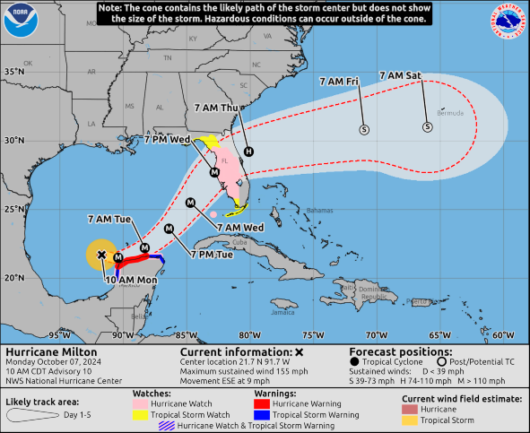
These circles are based on past errors and show where the storm center is expected to be about two-thirds of the time. The new cone will use oval shapes called ellipses instead of circles.
Hurricane Milton (2024) track forecast cones: Red dashed line shows the current total-error cone. White shading shows the new cone based on direction and speed errors. The red line is for illustration only. (Via National Hurricane Center)
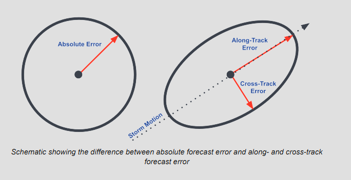
These ellipses better show two types of errors: how fast or slow the storm moves (along-track) and how far it drifts left or right (cross-track). It will cover 90% of possible storm paths, giving a wider and clearer picture of risk.
The experimental cone will be released shortly after each advisory. People will have a chance to give comments and feedback to help improve it.
JOE’S OPINION: This has the potential to be a huge benefit for the American people, and the other countries that we help forecast for in the Caribbean, Bermuda, Central America and more.
Last year, during our Tidal Flooding Talk show with Mike Brennan, Director, National Hurricane Center, I asked if it was time to make the forecast cone more accurate than the 66% probability that’s used.
Tropical forecasting has improved so much since 2002 that I feel like we could do better as a community to give people more certainty, while not putting the entire East Coast into the forecast cone.
Plus, be honest, how many of you really knew the forecast cone was only a two-thirds probability? Not many, I bet.
Expanding this out to 90% probability makes this much more helpful as meteorologists communicate to emergency managers, elected leaders and more. They, in turn use their local knowledge to make safety decisions (like evacuations) and communicate them to the public.
I wasn’t expecting the cone to take on a more oval shape. However, that’s an amazing bonus. It’s pretty well known in the weather world that the National Hurricane Center has progressed accurately forecasting the direction of a storm (cross-track) more than it’s speed (along-track). Though let me be clear, both have seen impressive improvements in the year 24 years.
Graphic showing difference between absolute forecast error and along- and cross-track forecast error (via National Hurricane Center)
This won’t solve all issues. We will still deal with the fact that impacts still happen outside of the forecast cone. However, this answers many of the existent issues we have.
While it’s experimental, you’ll be able to view it alongside the official forecast cone, with it’s two-thirds probability and more circular path. Typically, these are experimental for one to three years before becoming operational. So, look for this upgrade to be official between 2027-2029.
More on hurricane season
You can read the official press release on all of the updates from the National Hurricane Center here. The NHC is forecasting a less active than average season for the Atlantic Hurricane Basin, mainly due to the developing El Nino. However, it only takes one hurricane to strike you for you to remember it as an active season.