SATURDAY’S FORECAST | Happy weekend weather forecast! The growing season threatens to end this weekend in more inland places with the cool mornings. The afternoons will feel like quintessential Fall, perfect for the trunk-or-treats in full swing!
I’m still eying a coastal storm next week, too. No hype. Let’s see where we stand.
Follow my work: www.cupajoe.live Jolt your brand, advertise with me: joe@cupajoe.live
FRIDAY’S FORECAST | Sweata weather! Ok, I have a button down shirt on but I’ll break out the sweater this weekend. It’s getting increasingly cool with more frosts around. What *won’t* your generic weather app tell you? The story on next week’s possible coastal storm.
Follow my work: www.cupajoe.live Jolt your brand, advertise with me: joe@cupajoe.live
Occasionally, while I’m doing a public talk, I’ll be asked
“What are your thoughts on climate change, Joe?”
And, usually, I’ll respond with something like
“I’m not here to tell you my thoughts on climate change. Let me tell you what’s going on.”
Climate change is not a religion. You don’t believe in it or not.
There are facts and forecasts. Then, there’s what to think, not think, do or not do about it. That’s where your beliefs come in.
My job is the facts and forecasts.
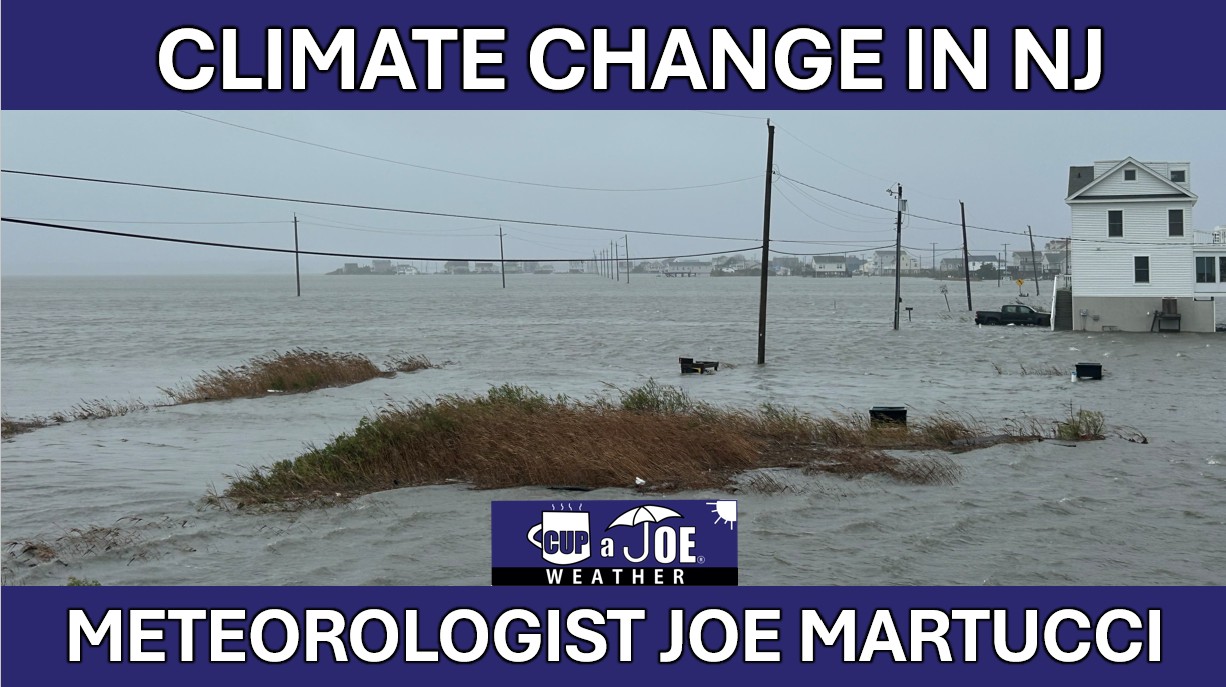
In a warmer, wetter and more extreme New Jersey climate, that’s what I do here in this video series. Thanks for watching and email joe@cupajoe.live with any questions.
The facts and forecast vs. beliefs on climate change
Climate change isn’t a religion, you don’t believe in it or not.
🌀How climate change does, and does not, impact hurricanes
Tropical cyclones has and will see significant changes from climate change. However, climate change does not have its fingerprints on everywhere associated with hurricanes and tropical storms.
🏜️ Climate Change in New Jersey: Drought
More extreme precipitation in a climate changing worlds means drier dry weather and wetter wet weather. However, how much drought we’ve seen hasn’t changed in New Jersey.
🌧️❄️ Climate change in New Jersey: When it rains, it pours and snow is heavier, too.
Climate change has brought more rain and less snow. However, how it rains and snow also changed, too.
🌡️ Climate Change in New Jersey: Temperatures
Since records in NJ began in 1895, the average temperature rose by 4 degrees. Vineyards can now produce grapes are far north as Interstate-78, where in the 1970s, it was mainly limited to Cape May County. However, heat is the biggest killer in the United States on an annual basis and those numbers only get higher, even with air conditioning.
Climate Change in New Jersey: The complete guide
Follow my work: www.cupajoe.live Jolt your brand, advertise with me: joe@cupajoe.live
I don’t know about you, but the days definitely feel shorter for me. By 6 p.m. it’s getting dark, and it’s pitch black by 7 p.m. Not only that, but my early-morning walks are remarkably close to needing long pants and a sweatshirt. My wife is wearing a winter jacket now.
In other words, it’s getting deeper into fall.
One of the annual staples of autumn is the arrival of the first frosts and freezes. A heavy frost, or a few hours of sub-freezing temperatures, end the growing season for the many farms and gardens that call this area home.
As of Oct. 23, there has been no widespread frost for the coastal counties. Parts of the Pine Barrens in Cape May, Atlantic and Ocean counties saw frost on Oct. 18. But according to the National Weather Service, which issues frost advisories and freeze warnings, the growing season continues.
For most of us, frost is just something cool to look at or photograph for a social media post. However, for farmers and gardeners, this is a concern that marks the end of the growing season.
A freeze is when the air temperature falls to 32 degrees Fahrenheit. However, keep in mind that the air temperature is measured roughly 6 feet above the ground surface. During the night, colder air can be found lower to the ground where fruits, vegetables and flowers grow. It could be 33 or 34 degrees on the sensor, while a ground freeze is still occurring.
A hard freeze is another term you will hear.
“A freeze in which seasonal vegetation is destroyed, the ground surface is frozen solid underfoot and heavy ice is formed on small water surfaces such as puddles and water containers,” is what the Glossary of Meteorology says.
A hard freeze is the one that farmers and gardeners are leary of. Generally, a temperature at or below 28 degrees is hard freeze territory.
Freezes do not have to have frost. Frost needs a light wind and cloudless sky to occur. Sub-freezing temperatures, as we know, can occur with clouds and strong, biting winds during the winter.
Average first frost and freeze dates
On average, the Pinelands, and the more populated inland spots experience frost sooner than the beach towns do.
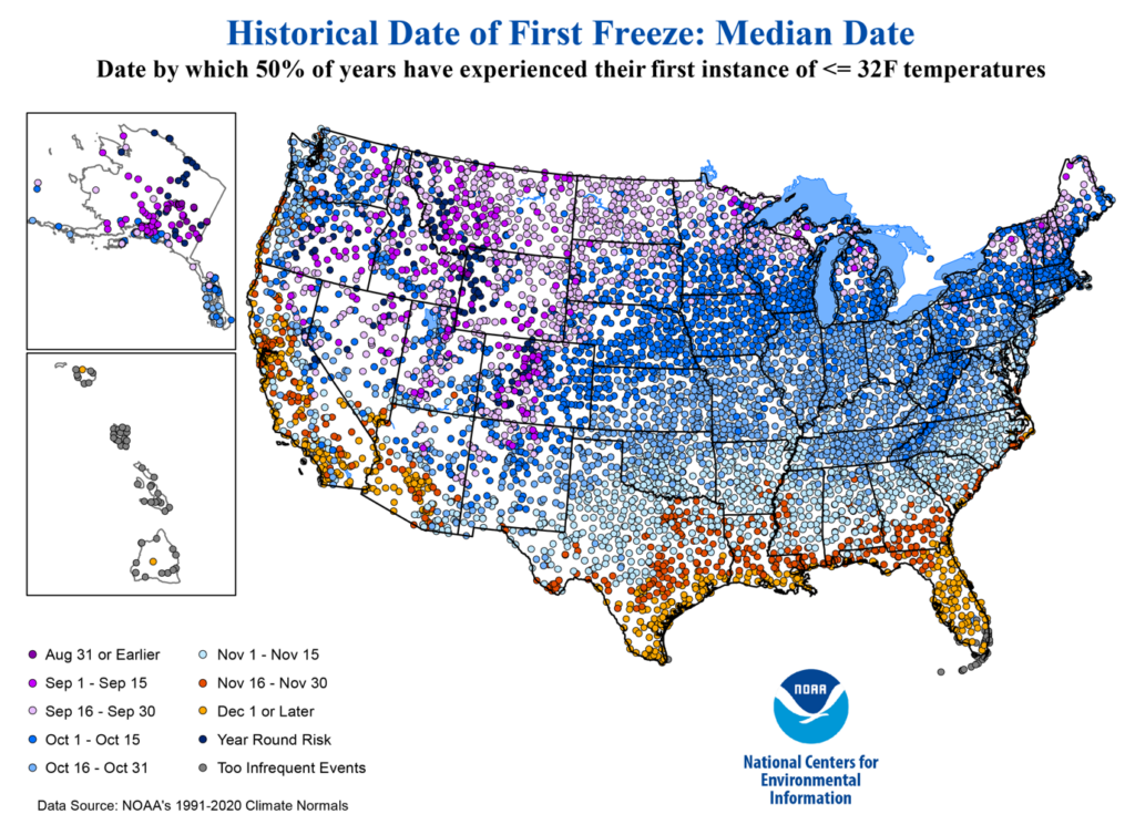
For Pinelands communities such as Estell Manor, the median first frost is mid-October. The typical first freeze is Oct. 18 with a hard freeze date of Oct. 30.
For the inland parts of the Jersey Shore counties, away from the Pinelands, the average first frost is around Oct. 20. The average first freeze is Oct. 19-22 with the first hard freeze of Nov. 2-5.
For the beaches, the average first frost is Nov. 1-10. The average first freeze is Nov. 24, with a hard freeze date of Dec. 5.
All the data is from the National Oceanic and Atmospheric Administration.
The only places where it’s odd not to have a freeze yet are in the Pinelands. However, it was only two years ago when the first freeze was Nov. 12. In fact, since records began in 1965, a first freeze in November happened eight times.
First frost or freeze of fall 2025
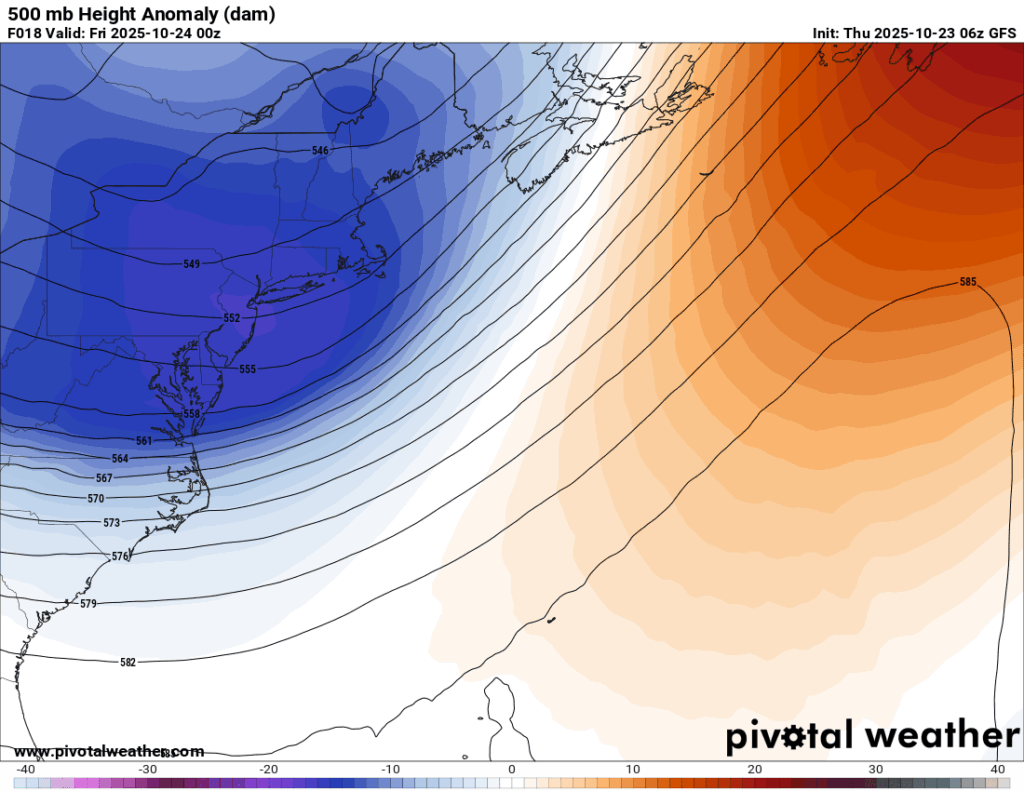
For the Pinelands, the upcoming weekend offers a good chance for the first frost or freeze of the season. A trough of low pressure will swing through, bringing colder air in from aloft. If the sky is clear enough and the winds light, we should have frost, and a freeze is possible.
How high in the atmosphere you must go in order for the air pressure to be 500 millibars. Units are in decameters (tens of meters). The lower the number, the coder the atmosphere is. Blues and purples indicate a thinner than usual atmosphere. Data via the Global Forecast System (American) model.
However, I believe places like Cape May Court House and Longport will remain frost-free and freeze-free after this.
So, what’s next? The first five days of November look to have a good surge of cool air moving in. By that point, average inland low temperatures will be 36-40 degrees; that’s a bit cooler than average and puts us into frost or freeze territory.
Assuming the inland areas have a frost or freeze by Nov. 5, that leaves just the beaches. That’s too far out from now to make an educated forecast. However, you can follow me online for more on that.
Climate change’s role
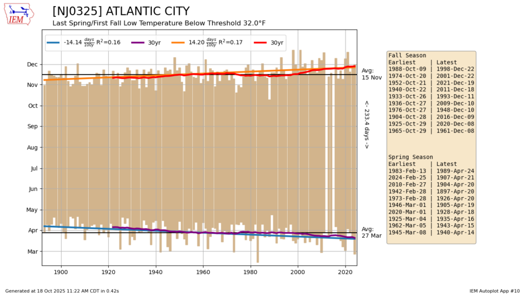
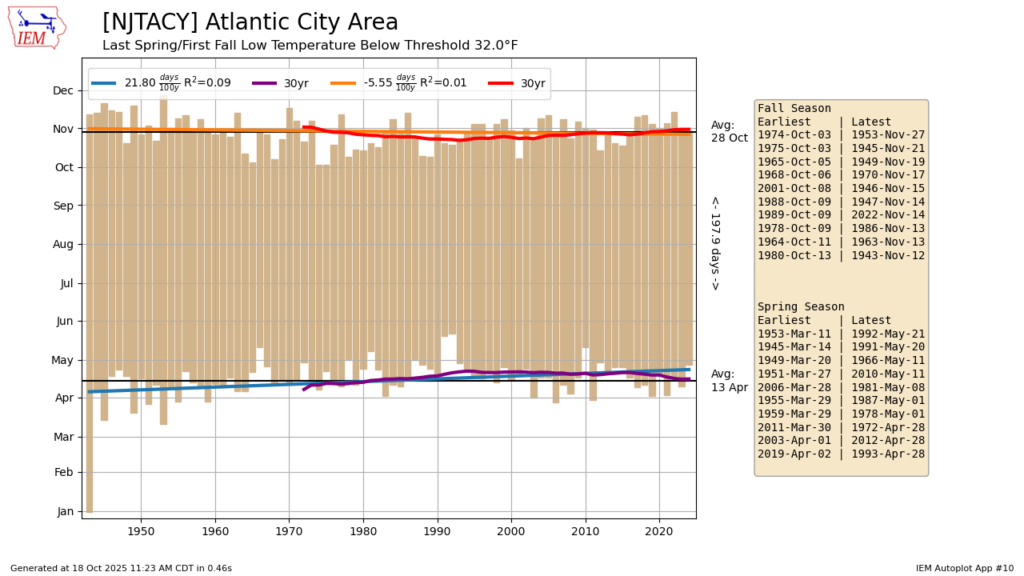
At the Sen. Frank S. Farley State Marina in Atlantic City, the 30-year average date of the first freeze of the year has shifted later, according to NOAA.
1881 to 1910: Nov. 6
1951 to 1980: Nov. 11
1991 to 2020: Nov. 24
That’s an 18-day shift.
Data via the Iowa Environmental Mesonet
Atlantic City International Airport has seen no major shift over time. Both periods were Oct. 23.
Data via the Iowa Environmental Mesonet
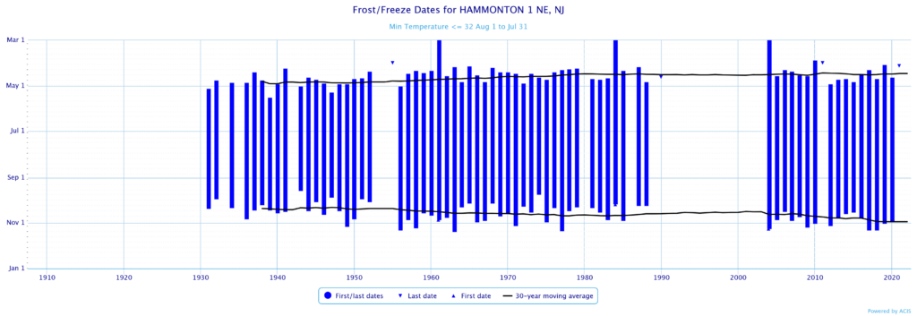
However, Hammonton did see a shift later:
1951 to 1980: Oct. 21 1991 to 2020: Oct. 30
Insert Hammonton First/Last Freeze date over time
Data via the National Oceanic and Atmospheric Administration
Another inland area, Freehold, Monmouth County, had a similar trend.
1951 to 1980: Oct. 17 1991 to 2020: Oct. 24
Today’s climate change is like a steady, fast climb up a warm hill—quicker than Earth’s usual slow ups and downs over thousands of years, but not as sudden and shocking as a giant volcano or asteroid that would slam the planet with instant cold before heating it up.
Joe Martucci, a Certified Broadcast Meteorologist and Digital Meteorologist, is the President and Director of Meteorology for Cup A Joe Weather and Drone. You can connect with him at cupajoe.sparkable.opalstacked.com/.
THURSDAY’S FORECAST | In another sign of Fall, I have our first inland frosts of the season in the forecast! What won’t your app tell you? The context behind a possible coastal storm for Halloween.
Follow my work: www.cupajoe.live Jolt your brand, advertise with me: joe@cupajoe.live
WEDNESDAY’S FORECAST: Last night brought a thunderstorm and light rain to the Jersey Shore. Peace out to that. Dry air, and a long stretch of it are on the way! One thing you’re app won’t tell you? A potential Halloween(ish) nor’easter.
Follow my work: www.cupajoe.live Jolt your brand, advertise with me: joe@cupajoe.live
TUESDAY’S FORECAST | Did ya see the Orionid Meteor Shower last night?! I shared one viewer’s sparkling view of the night sky. That clear sky turns into cloudy, rainy skies Tuesday night. Then, a long stretch of cool autumn weather ahead.
Dominate your fantasy leagues and bets with weather-driven data. MeteoOdds gives you innovative tools, player/game weather impacts, and detailed forecasts. Join FF+ by using the code WEATHER and get 50% off, for life! Turn forecasts into fantasy wins — only at www.meteoodds.com.
SATURDAY’S FORECAST: Brrr! It’s a cold one this morning. If you’re not ready for this weather yet, just wait a little. I spy a high around 70 degrees by the time the weekend is done. A few rounds of rain, one with strong winds, comes next week. Follow my work: www.cupajoe.live Jolt your brand, advertise with me: joe@cupajoe.live
FRIDAY’S FORECAST | Fall, fall, fall! It feels just like it today. Highs reach the 60s. Our first frost of the season threatens to end the growing season Saturday morning. I’ll show ya where and then a nice look at our 7-day forecast.
Follow my work: www.cupajoe.live Jolt your brand, advertise with me: joe@cupajoe.live
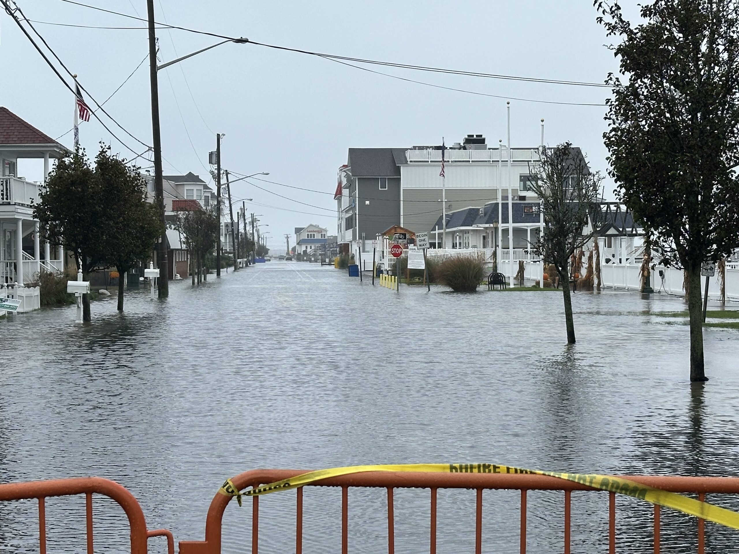
It ripped, roared and, most consequentially, flooded. The first nor’easter of the 2025-2026 cool-weather season may very well turn out to be the most powerful one. Here are the most impressive storm stats to me for the Jersey Shore and beyond.
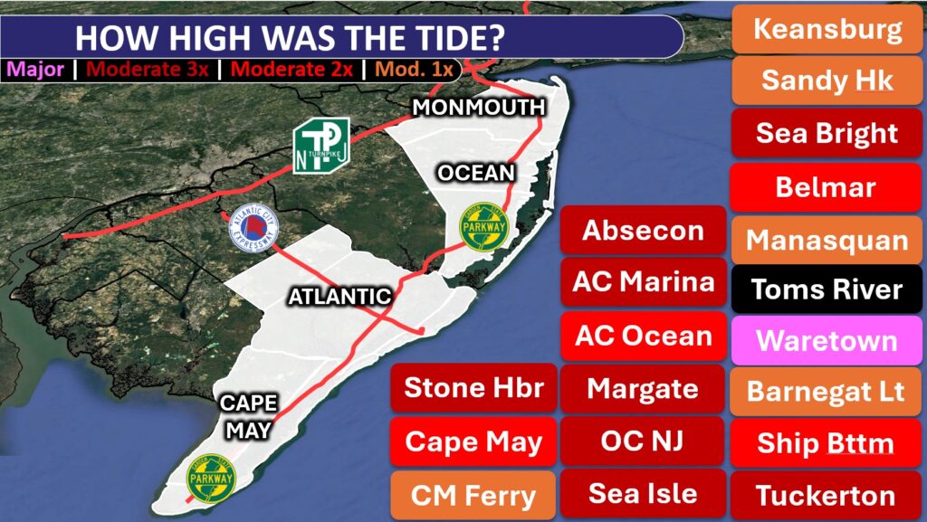
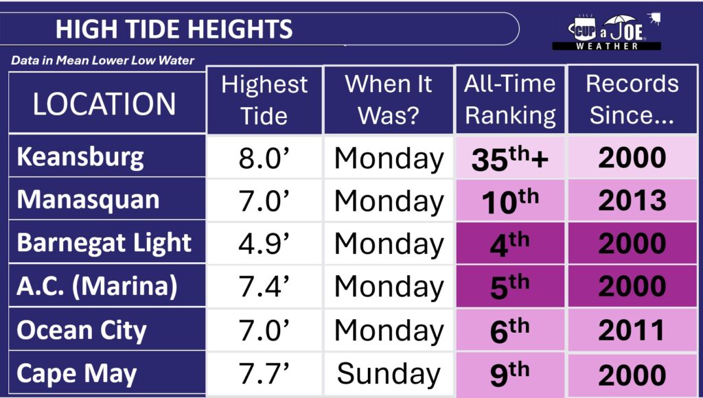
– The Sunday or Monday afternoon high tide was in the top 10 highest on record for nearly everywhere, from Cape May up to southern Monmouth County, according to the National Oceanic and Atmospheric Administration.
– Most of Cape May and Atlantic counties saw three consecutive tides in moderate flood stage.
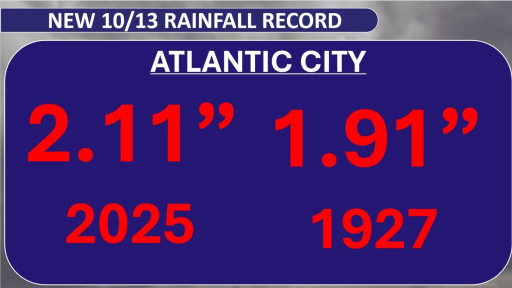
– Sen. Frank S. Farley State Marina broke a daily rainfall record that had stood since 1927.
Plus, while we will remember this as a nor’easter, there were tropical characteristics to this storm, too. Let’s explain the details for all of this.
How severe were the tides at the Jersey Shore?
Atlantic City Marina had its fifth highest tide on record, peaking at 7.4 feet above mean lower low water, the average height of the two lowest low tides Monday afternoon.
Ocean City had its sixth highest tide on record, reaching 7.0 feet above mean lower low water Monday.
Down near Exit 0 in Cape May, the ninth highest tide on record, peaking at 7.7 feet above mean lower low water, was experienced on Sunday.
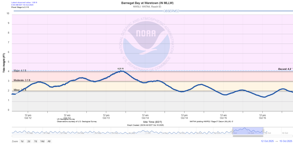
Ocean County ended up having the highest tides. Barnegat Light in the northern part of Long Beach Island, had the fourth highest tide on record. Meanwhile, across the Barnegat Bay in Waretown, 3 feet of water was recorded in the lowest-lying areas — their worst recorded tide.
Tide heights in Waretown, Ocean County, on the Barnegat Bay from Oct. 12 to Oct. 15. The 4.21 foot above mean lower low water is the highest in its recorded history (data via the National Oceanic and Atmospheric Administration).
Farther north Manasquan, Monmouth County, had its 10th highest tide. The least severe flooding was on the Raritan Bayshore. They stayed in minor flood stage.
There is a caveat to all of this. These records only go back to 2000 at the earliest. So it doesn’t count the 1991 or 1992 nor’easters, the 1962 Ash Wednesday storm or the 1944 hurricane, among others. However, there have been roughly 9,100 days between 2000 and fall 2025. This tide ranks in the top 0.1%. That’s impressive.
To put things in perspective, it helps to have a recent event with which to compare the storm, so let’s consider Hurricane Erin.
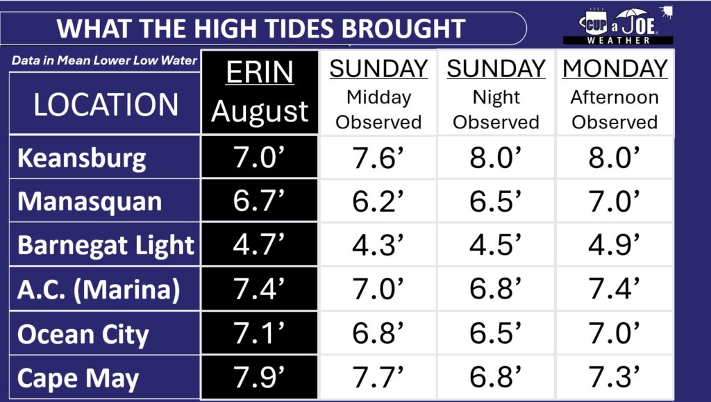
In late August, Erin brought the highest storm surge on record to the following locations: Absecon, Atlantic City (Inside Thorofare), Sea Isle City, Avalon, Stone Harbor and Cape May (bayside), according to NOAA.
For the South Jersey shore, south of Long Beach Island, the highest tide stayed near Erin’s height, whether it happened on Sunday or Monday afternoon. North of LBI, at least one of the two tides from the nor’easter were higher than Erin.
The South Jersey shore could have been worse. Thankfully, winds on Monday morning were from the northwest — offshore — which pushed some of the water out. Had they been northeast, like the rest of the Jersey Shore was, towns like Ocean City and Somers Point would have had tides higher than Erin on Monday afternoon, pushing into major flood territory.
How much beach erosion occurred at the Jersey Shore?
The exact details won’t be known until towns and the Army Corps of Engineers complete their post-storm surveys. However, expect to hear that issues are widespread and severe for a few.
Towns already have stark cliffs of sand on the beach from Erin in August. Tack on additional erosion from a storm in September, and our sand infrastructure was already worse than it would be this time of the year going into the Oct. 12-13 storm.
I imagine every beach town has more erosion than they’d like to stomach for it being so early in the erosion season. Hopefully, this winter and next spring will have fewer nor’easters than usual.
Gusts over 60 mph
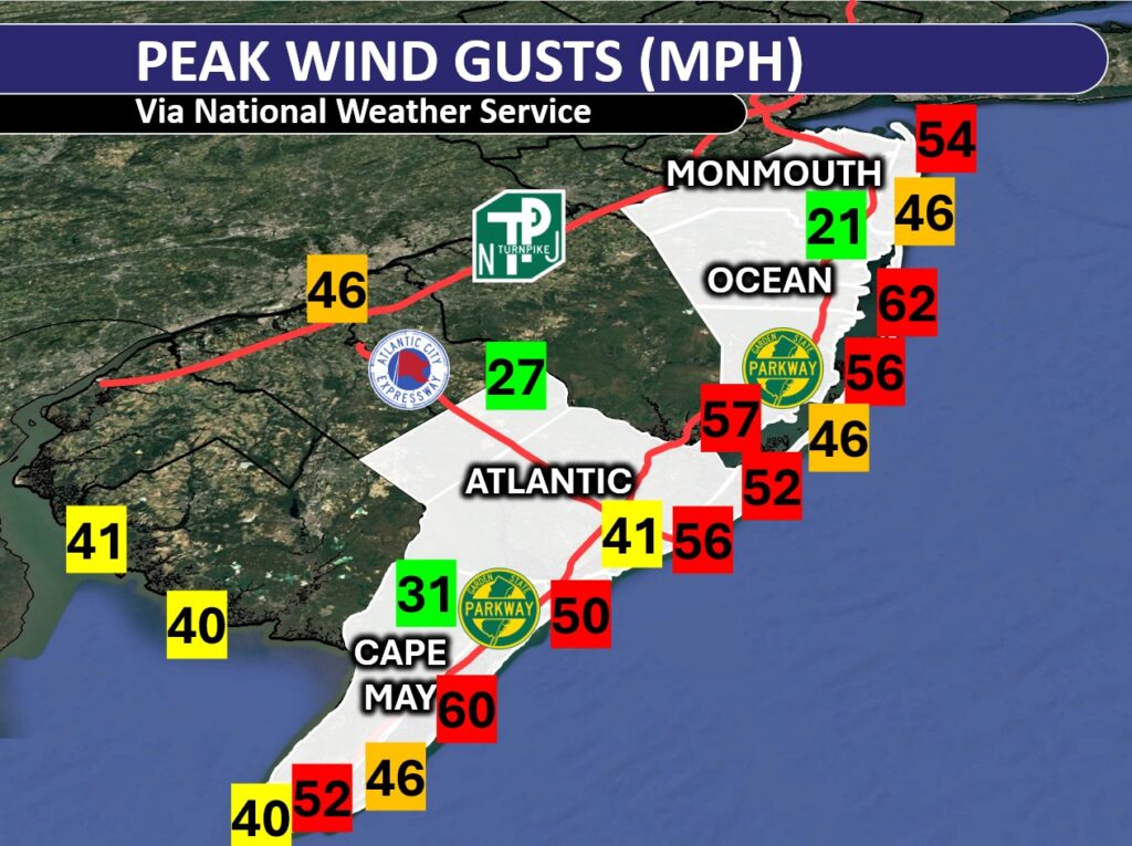
Wind gusts over 45 mph were widespread east of the Garden State Parkway, and on the bayshores. Island Beach State Park in Ocean County had the highest reported wind gusts, with 62 mph recorded at an Office of the New Jersey State Climatologist weather station. However, Avalon in Cape May County and Surf City in Ocean County also touched 60 mph.
Here are some other top gusts:
Atlantic City – 56 mph
Brigantine – 52 mph
Cape May Harbor – 52 mph
Ocean City – 50 mph
The sustained winds, or constantly blowing ones, made for whistling trees and rattling outdoor furniture Sunday and Monday. Generally, it was 20 to 30 mph at the shore.
Gusts were much weaker inland. Woodbine in Cape May County reached 31 mph, and Hammonton in Atlantic County only got up to 27 mph.
Rain was heavy, too
Rain was the least of our concerns with this storm, but we still had a soaking; that is, east of the Garden State Parkway. Atlantic City Marina broke an Oct. 13 daily rainfall record with 2.11 inches of rain, beating the previous record set back in 1927, according to the NOAA.
Generally, rainfall totals were between 2 and 3 inches in Atlantic County. Cape May County generally had 1 to 2 inches of rain.
Once you got away from the four coastal counties — Cape May, Atlantic, Ocean and Monmouth — rainfall measured only up to an inch. Out near Trenton and Philadelphia, it was less than a half inch.
Jersey Shore streaming weather channel
I am targeting a launch date between Oct. 18 to 21 for the Jersey Shore’s streaming weather channel. Thanks to Sparkable (who also run the Shore Local website), everything Jersey Shore weather, with a little drone, will be on my YouTube channel and website for your viewing pleasure.
Tide and marine forecasts, current conditions, forecast videos, radar and support from our sponsors will all be on there. I also want to see your Jersey Shore photos! Submit your sunrises, snow, thunderstorms and fall foliage to be featured in a special shot on the livestream.
Keep it on your smart TV or computer all day long. Stay tuned for more details.