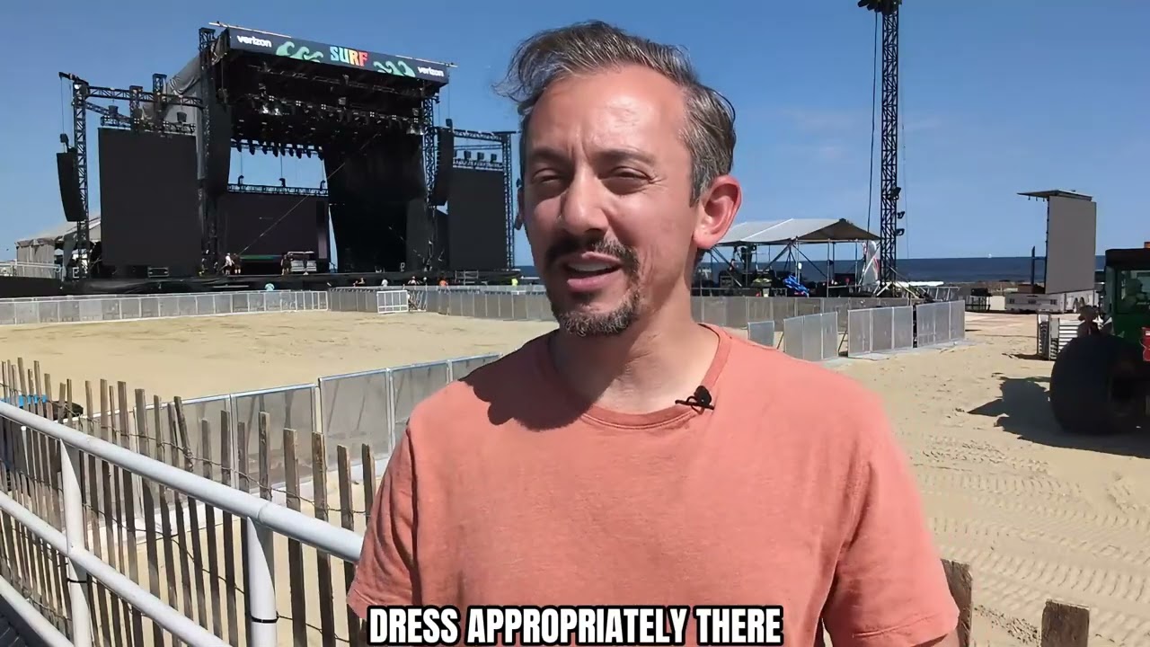
THURSDAY’S FORECAST | Bet your bottom dollar that the sun will come out… today! The coastal low will continue to weaken and move away from the Jersey Shore. That means sun for the afternoon and a few days after that, too. I have your only Jersey Shore local video forecast here.
WEDNESDAY’S FORECAST: Copy from Tuesday, add a little rain to the northern Jersey Shore and you have today’s forecast. It’s PERFECT to get indoor things done, or read a book you never did yet lol. Brighter days are ahead. Enjoy!
Follow my work: www.cupajoe.live Jolt your brand, advertise with me: joe@cupajoe.live
SATURDAY’S FORECAST | Mother Nature must be coming to the Jersey Shore this weekend because our weather is beautiful from end to end! Woohoo. Tune on in.
Captain’s Tree Service handles all your tree needs, including tree removals, trimming, pruning, and 24/7 emergency care. They’re reliable, affordable, and trusted by families. Call the Captain today for a free estimate at (856) 883-7682!
Follow my work: www.cupajoe.live Jolt your brand, advertise with me: joe@cupajoe.live
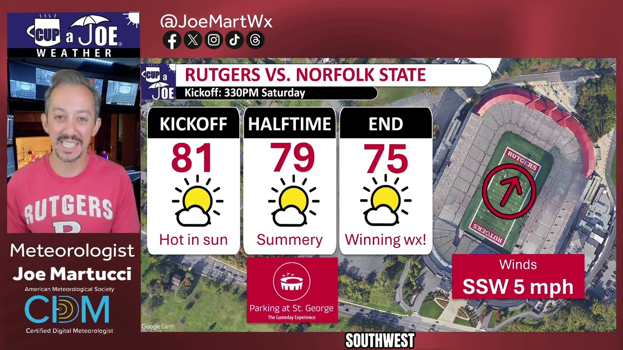
This Saturday’s game vs. Norfolk State is muuuuuuch drier than last weekend’s game. Enjoy the sunshine, but it’ll get toasty in the North End Zone. Trust me, I’ve had season tickets there for years. Go RU!
Located just 1/3rd of a mile from SHI Stadium, the St. George Greek Orthodox Church is THE place to park and tailgate for Rutgers football games! Lots of space, clean bathroom and excellent service. Reserve your space at www.rutgersparking.com.
FRIDAY’S FORECAST | It’s a Locals’ Summer September special! And, with 3 major events at the Jersey Shore this weekend, Mother Nature is celebrating with us just in time. Next week may be stormy, though. I’m thinking over the weather options.
Follow my work: www.cupajoe.live Jolt your brand, advertise with me: joe@cupajoe.live
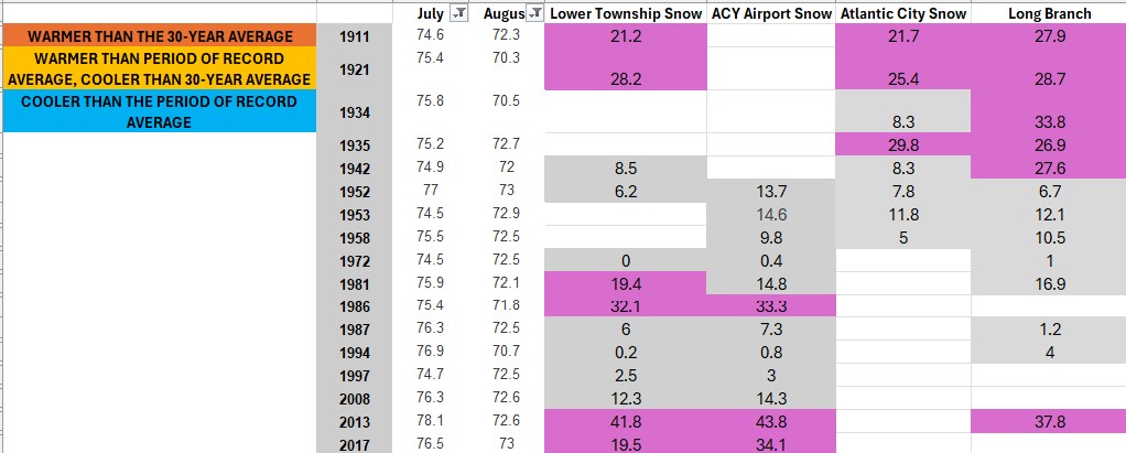
History shows that when July is hotter than usual and August is cooler than usual, like what just happened at the Jersey Shore this year, it’s a good clue about what the coming winter might be like. Here’s why past weather patterns suggest it could be colder than average.
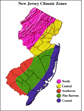
Using information from the Office of the New Jersey State Climatologist, where I did research during my senior year at Rutgers University, I collected average temperature data for every month since 1895. I focused on the Coastal Zone, which the climate office describes as areas east of the Garden State Parkway in Monmouth, Ocean and Atlantic counties, plus almost all of Cape May County.
Snowfall data came from the National Oceanic and Atmospheric Administration for Lower Township, Atlantic City International Airport, Atlantic City and Long Branch. While Atlantic City doesn’t report snowfall anymore, they did from 1874 to the 1950s, which I used for this project.
What do a hot July and a cooler August mean for the Jersey Shore’s winter temperatures?
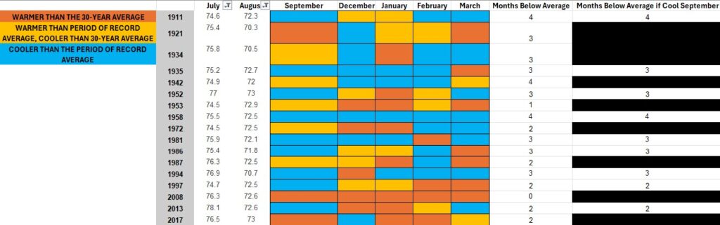
Going back to 1895, there have been 18 years when a cooler-than-average August followed a hotter-than-average July in the Coastal Zone. That includes 2025 when August wound up 3.2 degrees below average – 31st coolest of the 130 years of record keeping. July was 2.4 degrees above average – the sixth hottest on record. The most recent such period before that was 2017.
Average here is defined as the period of record average from 1895 to 2025. Usually, though, meteorologists use a 30-year average to discuss what is above or below average. The period of record average is cooler than the most recent 30-year average due to the changing climate.
I then investigated what temperatures were for December through March for the months following those July-August stretches. There was a strong signal for temperatures to be colder than our most recent 30-year average. The 17 years broke down like this for the four-month December-March period.
Colder than average for all four months: 3 Three months colder than average: 7 Two months colder than average: 5 One or no months colder than average: 2
In other words, 59% of years had all months colder than the 1991-to-2020 average; 12% had no or only one month colder than average.
If September is chilly, too, history says a frigid winter is likely.
September is also likely to be cooler than the period of record average, given the first 10 days of the month, as well as the forecast through at least Sept. 18.
The historical likelihood that winter will be colder than average, based on just those years, is even higher. Of the 12 times this happened, 10 had at least three months between December and March that were colder than average.
The 17 years on record that had a hotter than average July and then a cooler than average August. The blue and yellow boxes indicate temperatures cooler than the 1991-2020 climate average for those months in row 1.
Hot July, cool August: Snowy winter at the Jersey Shore?
The history books don’t show a clear link between a super-hot July and a cooler-than-usual August when it comes to snowy winters. Here’s what we found about snow at four Jersey Shore weather stations after 17 winters with that kind of July and August:
Lower Township: 6 winters had more snow, 7 had less.
Atlantic City International Airport: 3 winters had more snow, 9 had less.
Atlantic City: 3 winters had more snow, 4 had less.
Long Branch: 6 winters had more snow, 4 had less.
Each weather station has been around for different amounts of time, so the number of years checked isn’t the same for all. But if you love snow, you might be excited to know that the last two times this happened (the winters of 2017-’18 and 2013-’14), there was more snow than usual. Also, if September is cooler than normal, the chances of a snowy winter go up. Out of 12 years with a hot July, cool August, and cool September, most had more snow than average.
Snowfall totals for four Jersey Shore locations in winters where the previous July was hotter than average and August cooler than average. The purples indicate a snowier than average winter. The grays indicate a less snowy than average winter.
Does history matter when it comes to this winter’s forecast?
Brigantine’s local roads remained icy two days after the first inch of snow in nearly two years fell on New Jersey in January 2024. (Photo by Joe Martucci)
September is in the middle of the August-to-October time frame that long-range forecasters typically use to do their winter forecasts. As part of their research, they look at what the weather in previous springs and summers was like. They then look at what the following winter was like to give them an idea of what to expect. So if, for example, 2017 had conditions similar to 2025, they’d look at the winter of 2017-’18 to give New Jerseyans an idea of what this winter will be like.
They’re called analog years in the weather world. While each forecaster has their own winter formula, analog years are a part of the process, but usually not the main source of information they use.
I don’t do my own winter forecast. However, look for a winter forecast by the top Northeast experts in October. We can read whether they used the winter of 2017-’18 or 2013-’14 as an analog year.
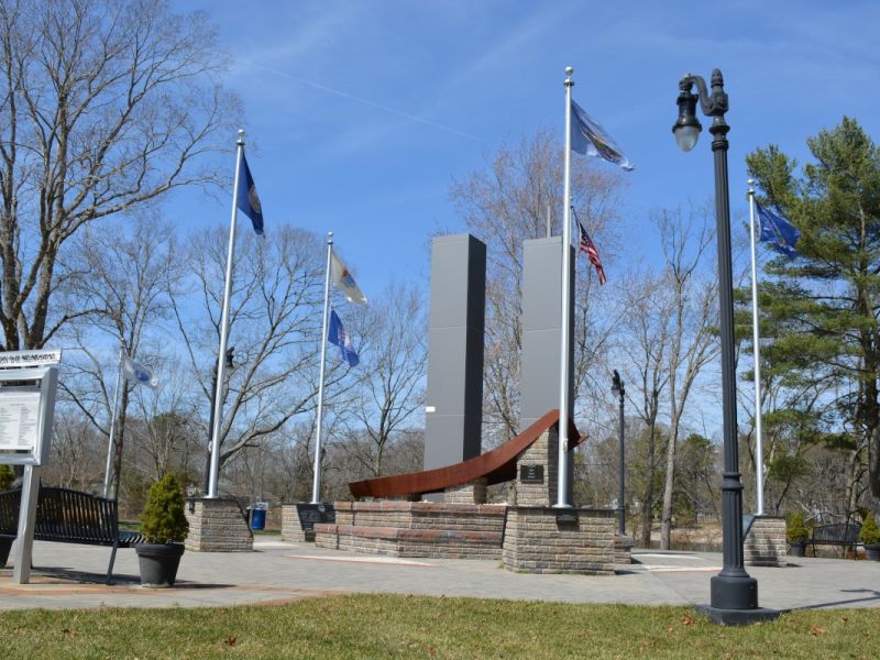
9/11 at the Jersey Shore
Via the City of Absecon
In this Shore Local Weather Column, published on Sept. 11, let’s reflect on the tragic events of Sept. 11, 2001. That day brought uncertainty, pain and incredible strength to our nation. As Alan Jackson’s song asks, “Where were you when the world stopped turning?”
If you’re old enough to remember, take a moment to think back on where you were. You might also consider visiting one of the 9/11 memorials along the Jersey Shore. My favorite is in Absecon – it’s powerful, with a lifelike replica of the Twin Towers that’s both beautiful and deeply moving.
Joe Martucci, a Certified Broadcast Meteorologist and Digital Meteorologist, is the President and Director of Meteorology for Cup A Joe Weather and Drone. You can connect with him at cupajoe.sparkable.opalstacked.com/.
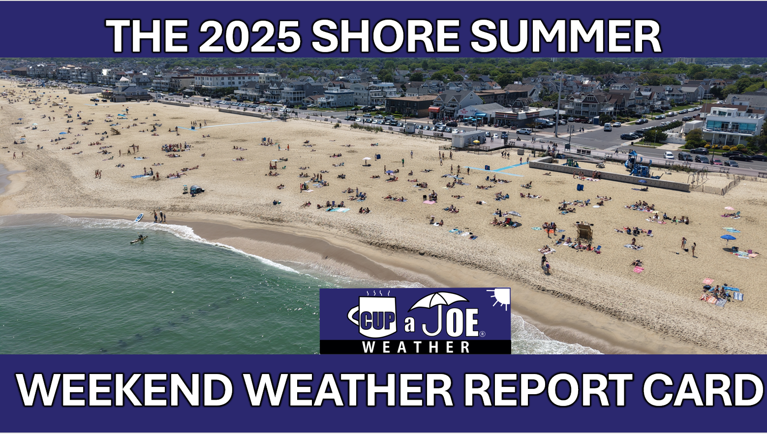
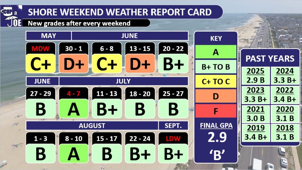
The past 11 weekends at our beach towns graded a ‘B’ or above, but it still wasn’t enough as 2025 was the lowest performing summer in the eight years of my Shore Summer Weekend Weather Report Card.
How the report card is graded
Since 2018, we’ve graded the shore summer weekends from Memorial Day to Labor Day. That’s Friday to Sunday, but also Mondays for Memorial Day and Labor Day. Fourth of July is either included in the weekend or on its own. It was July 4-7 for the 2025 edition.
I say we’ve graded because you shape the report card. You helped set the criteria for the perfect ‘A’ for your summer shore weekends.
An ‘A’ requires temperatures between 75 and 85 degrees, no rain, winds between 5 and 15 mph, low humidity and sunny to partly sunny skies. This report card covers Cape May to Sandy Hook, so if it’s 90 degrees far south, but 85 degrees everywhere else, that won’t ruin a perfect ‘A’ grade.
The 2025 report card for the Jersey Shore
The final grade point average for the 15 summer weekends was a 2.9; good enough for a ‘B,’ but not good enough to get us out of eighth place of the eight summers I’ve graded. You have to look at the beginning of the summer to understand why.
“The reason for these gloomy, cooler weekends is part bad weather luck, and part science,” I wrote on June 19.
New Jersey sat in the middle between two air masses; the jet stream floated over the state. That brought the cool, stormy weather. Then, in a stroke of bad luck, the same pattern repeated itself every seven days, on the weekends.
The warm, bright summer weather that most of us know and love doesn’t settle in until mid-June. Poor weather weekends early in the season are common. Still, 2025 was the worst start in our eight-year history of report cards up until then. After that, the Jersey Shore studied hard to bring up its grade, but 2025 never broke out of last place.
The 11 weekends, from June 20 to Labor Day weekend, were all either a B, B+ or an A. If we just looked at those, the grade point average would be a 3.3; that’s a B+! This included a perfect ‘A’ for the Fourth of July weekend. I was away on vacation, but just talking with you and seeing the weather data, it’s fair to say it was the most comfortable Independence Day weekend in years.
We also had another ‘A’ for Aug. 8-10. Like most of August, the humidity stayed low and the amount of sunlight stayed high.
This past weekend, Labor Day, earned a B+. The only downside was it was a bit too cool, in the low 70s for highs most days. However, it was plenty sunny, not humid at all and had pleasant breezes. It’s a great sign of the Locals’ Summer September to come.
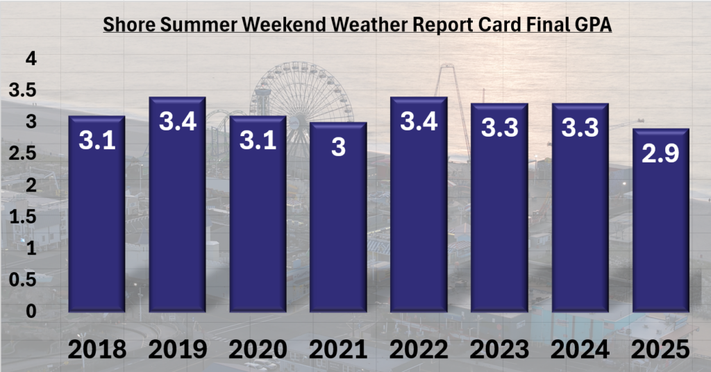
This was the lowest grade in the history of the report card. However, the 2.9 is just half a point away from the highest grade earned in the summers of 2022 and 2019. In other words, the shore never has a poor summer, climatologically speaking.
The eighth annual Shore Summer Weekend Weather Report Card
Furthermore, there was plenty of good weekend weather after Father’s Day, when summer kicks into high gear here.
Final grade point averages by year
2025 – 2.9 (B)
2024 – 3.3 (B+)
2023 – 3.3 (B+)
2022 – 3.4 (B+)
2021 – 3.0 (B)
2020 – 3.1 (B)
2019 – 3.4 (B+)
2018 – 3.1 (B)
How will September’s weather be?
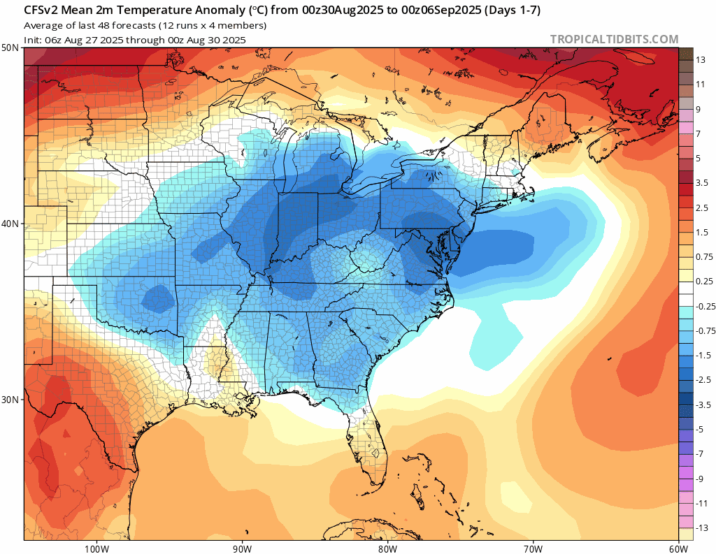
Temperatures should wind up at or just below average for the month of September. I don’t see a big change on the horizon taking us out of the generally cooler and drier weather pattern we’ve been in since the beginning of August.
The CFS forecast computer model for the month of September. The animation is for a week timeframe, seen on the upper left. The blues indicate cooler than average temperatures, which NJ is expected to see for most of September. (via TropicalTidibts.com)
High pressure should generally center itself in Pennsylvania or West Virginia. That will bring us another drier-than-average month, unless a tropical system comes through.
Then, since winds spin clockwise around high-pressure systems, our winds will generally be out of the northeast. That should keep ocean water temperatures in the 70s most of the month, but also keep our on-land high temperatures mostly in the 70s as well.
So, it will be very comfortable with plenty of good days to spend by the water for Locals’ Summer September.
We do need the rain, though. While not exactly known at the time of this writing, the beach towns should wind up with a top 10 driest August on record, according to NOAA’s Southeast Regional Climate Center. The mainland was still below average, just not as much. Farther away, Millville should be the driest August on record. Drought in New Jersey spread and worsened tremendously last September. Let’s hope that doesn’t happen again.
Thanks for following the Shore Summer Weekend Weather Report Card. I hope you enjoyed seeing the grades as much as I like posting about them in my videos and on social media. Now, happy locals summer!
Joe Martucci, a Certified Broadcast Meteorologist and Digital Meteorologist, is the President and Director of Meteorology for Cup A Joe Weather and Drone. You can connect with him at cupajoe.sparkable.opalstacked.com/.
WEDNESDAY’S FORECAST | The sunshine and comfortably mild temperatures continue for another day! Turns out, these cool mornings are making history as well for us at the shore. Enjoy the sunshine! Rounds of rain return Thursday night.
Follow my work: www.cupajoe.live Jolt your brand, advertise with me: joe@cupajoe.live
The same weather pattern has been repeating itself since beach season began on Memorial Day weekend — heat and sunshine mid-week, followed by cool, sometimes wet weekends — and it’s not a good one for our shore economy.
If you really want to get technical about it, the last time there was no measurable rain at any Jersey Shore location was May 10-11, according to data from the National Oceanic and Atmospheric Administration, and the Community Collaborative Rain, Hail & Snow Network (CoCoRaHS).
That being said, the weekend of May 17-18 only had less than a 10th of an inch of rain. Furthermore, we needed that May and early June rain because it helped crush our worst drought since 2002. Without it, the state drinking water supply would have been in serious trouble as water usage peaks about now.
My Shore Summer Weekend Weather Report Card is off to its worst start in the eight years it’s been done. Look for new updates on my social media pages after the weekend ends.
The reason for these gloomy, cooler weekends is part bad weather luck, and part science.
The science
The summer weather we think of – sunny, humid, hot inland, but cooler by the water – doesn’t really settle in until about the middle of June, which is now.
Obviously, Father’s Day weekend didn’t feel like summer weather was near. Highs struggled to reach 70 degrees, and clouds and showers were around. However, long-term weather science, what we call climatology, proves that summer weather is coming soon.
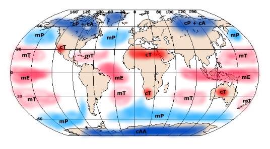
Up until this point, our weather is dominated by what’s called the Maritime Tropical Air Mass, which brings hot and humid weather pushing into the Continental Polar Air Mass – a dry, cold air mass that sits over us during the winter. The result is rain, thunderstorms and wind as New Jersey sits in the middle of these clashing weather forces. Eventually, the Maritime Tropical Air Mass wins out, but that doesn’t happen until about now, in mid-June.
Origins of airmasses across the globe. New Jersey is influenced by the cP, Continental Polar airmass from roughly October to May. However, the mT, Maritime Tropical airmass, dominates during summer. That brings the fairly consistent hot and humid weather.
That explains the potential for highs in the 60s and 70s as well as rain makers. However, it doesn’t explain why this happens on weekends. For that we look to the jet stream.
The jet stream is the river of air between 25,000 and 40,000 feet above sea level. To the north is a cooler air mass, in our case the Continental Polar Air Mass, and to the south is a warmer air mass called the Maritime Tropical Air Mass.
The jet stream is a key driver of weather patterns. Think of it as a train track for low-pressure systems. When it’s over the Mid-Atlantic you can expect wetter, or at least cloudy weather. The jet stream does not move due west to east in a straight line. There are kinks in the jet stream called Rossby Waves.
Caused by the rotation of the Earth, Rossby Waves can create troughs of lower pressure (equatorward dips) or ridges (polarward bulges) of high pressure. There are usually about five of these Rossby Waves over the Northern Hemisphere at any given time.
The speed and size of the kinks vary, but they take anywhere from five to eight days to pass through. Seven days (one week) is right in the middle of that.
The bad luck
These low-pressure Rossby Wave troughs have been moving through New Jersey on weekends since mid-May. There’s no scientific reason for it — it’s just how things have played out. To break the bad luck you need a large pattern shift. That will come soon as the Maritime Tropical Air Mass settles into New Jersey. Until it does though, expect more of the same.
To see these pattern shifts in action, go to www.xmacis.rcc-acis.org. Go to single-station, then select graphs and then temperature graph in the drop down.
After that, select 2024 as the year and annual as the period of interest.
Finally go to station selection and choose your location via ID, list or search. You can select Atlantic City, for example, by going to change CWA, select PHI from the dropdownand then choose Atlantic City Airport area from the station option.
Temperatures don’t rise evenly in the spring and drop evenly in the fall. The big jumps (like Mid-March in 2024) or downturns (like early October in 2024), show those large scale pattern shifts.
Looking ahead
There will be a pattern shift soon making our first inland heat wave of 2025 very likely. Expect sizzling temperatures starting around June 22 and lasting until about the end of the month, which would mean reaching at least 90 degrees on three or more days in a row, with overnight lows in the upper 60s and 70s, too.
As for rain, we’re moving into the time of year when large-scale storm systems don’t impact New Jersey much.
Summer weather really settles in for the next three months now.
So we’re entering the season for pop-up showers and thunderstorms which can ruin a boat or beach day, but only briefly. I expect less gloomy weather in the weeks to come.
Joe Martucci, a Certified Broadcast Meteorologist and Digital Meteorologist, is the President and Director of Meteorology for Cup A Joe Weather and Drone. You can connect with him at cupajoe.sparkable.opalstacked.com/.