FRIDAY’S FORECAST | Yeah it’s gloomy this morning but I promise, the sun will come out! Once it comes out, it stays out this weekend. One concern? The possibility of wildfires. Like Smokey The Bear says, you can prevent wildfires.
THURSDAY’S FORECAST | I think we’re doing it! Thursday should be our last widespread freeze of the year at the coastal counties in NJ. It’s warmer air from here on out! That being said, drought probably gets worse.
Why settle for big chains? Choose Just4Wheels’ family-owned locations all across NJ! Rent brand-new sedans, passenger vans, box trucks and more today! Visit www.just4wheels.com or call 877-650-3500.
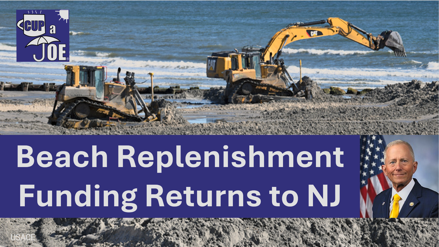
Beach replenishment projects are back on at parts of the Jersey Shore in 2026, just weeks away from peak beach season.
U.S. Rep Jeff Van Drew secured $99 million dollars from the Army Corps this week for beach replenishment.
Here’s what it is, and what it isn’t.
The $99 million is for beach replenishment projects that were slated to occur, but were discontinued after the congressionally directed spending ended in 2025. This money will come from “disaster funding”. $5 million in funding has already gone toward projects on the Maurice River, Cold Spring Inlet, Intracoastal Waterway and more.
The $99 million covers the projects in Rep. Van Drew’s 2nd district. At the Jersey Shore, that’s Cape May, Atlantic, Cumberland and Ocean county as far north as Berkeley Township.
Beaches in Stone Harbor, Avalon, Sea Isle, Strathmere and Ocean City will get the sand they need to keep the houses and roads safer from tidal flooding this year. However, when it’ll happen is still to be determined.
Photos and videos from Strathmere in particular has gone viral for the massive cliffs, or scarping, of beach that took places over the nor’easter season.
Rep. Van Drew says that he’s looking to secure $70 million in 2027 to complete beach fills in Long Beach Island, Atlantic City, Ventnor, Margate and Longport.
Van Drew also introduced the Coastal Trust Fund Act. If it passed, it redirects exists offshore energy lease` money already collected by the federal money and puts it into a trust fund for beach replenishment.
WEDNESDAY’S FORECAST | Woo, it’s cold out! Highs today will be more like February than April. Such is life during spring. Our last freeze of the season is likely Thursday. Then a slow climb up the thermometer is on the way.
More on the meteor/comet in the sky Wednesday afternoon! Reports submitted to the American Meteor Society show that it was seen for less than 20 seconds and made a sound. It’s pretty fitting this happened as Artemis II’s human crew is exploring the solar system.
Embark on your next adventure with Travel with Donna, the shore’s premier full-service travel agency! This female-owned local gem is your ultimate travel guru. Reach out at Donna@TravelwithDonna.VIP or text 609-287-2870.
🌞TUESDAY’S FORECAST | Loads of sunshine for today, and tomorrow, and the next day, and the next day!
Sun doesn’t mean it’s boring weather, though. Tune in and get some facts your generic phone app won’t tell you.
Tired of water in your basement or crawlspace? Trust Finally Dry Waterproofing’s family-owned company to fix it right. We install permanent drainage solutions guaranteed for 2 ownerships with no limit! Get your FREE inspection at finallydrywaterproofing.net.
SATURDAY’S FORECAST | We have a big range in temperatures in the coastal counties Saturday. If you’re winds are east you’re only around 60F. Meanwhile, places with southwest winds will push 80F. Signs of spring indeed.
Then, despite what your phone app says, Easter Sunday is more dry than not! I got the details.
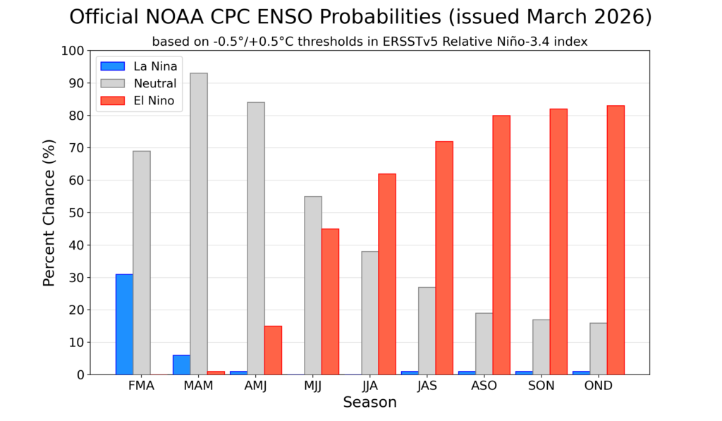
Goodbye La Niña and hello El Niño – possibly a “super” El Niño.
Expected between July and September, this shift in the Earth’s long-term weather patterns will define how we experience the upcoming hurricane season, as well as the snow and cold of next winter.
Forecasters from the National Oceanic and Atmospheric Administration give El Niño a greater-than-60% chance of developing during the summer. By the fall, during the peak of hurricane season, it’s an 80% chance.
By July, the chances of an El Nino developing are over 50% (via NOAA)
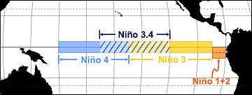
El Niño or La Niña is part of the El Niño Southern Oscillation (ENSO). This refers to the water temperatures off the Equatorial Pacific Ocean, from roughly Peru westward 7,000 miles. When water temperatures are warmer than average, it’s El Niño. When it’s cooler than average, it’s La Niña.
Via NOAA
Meteorologists break this down into four different zones within the ENSO region. I won’t explain it much here, but where those warmer temperatures are this summer and beyond will make a slight difference in what our long-term forecast will be.
Since the summer of 2024, we have been in La Niña. That typically means milder winters. However, both the 2024-2025 winter, and this past winter, were colder than average.
The frozen tundra of snow and ice we experienced for weeks this past winter bucked the La Niña trend, too. For hurricane season, 2024 was more active than usual, while 2025 was about average. That checks out with a La Niña pattern.
Let’s look at what El Niño will mean for both the 2026 hurricane season, and the 2026-2027 winter, plus what a “super” El Niño could mean for New Jersey.
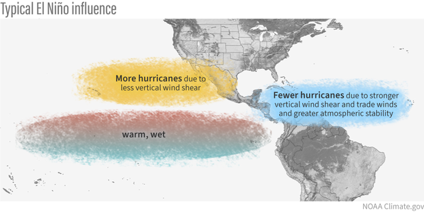
Quieter hurricane season likely
When El Niño is present, hurricane activity in the Atlantic Hurricane Basin goes down; it’s that simple. The Atlantic Hurricane Basin averages 14 named storms – seven hurricanes including three major hurricanes (Category 3, 4 or 5) per season, per Colorado State University. Since 1990, there have been 11 hurricane seasons with El Niño. Seven were less active, while two were about average and two were more active.
More than likely, this hurricane season will be as active or less active than average. With a 24% chance of the eye of a tropical storm or hurricane being within 50 miles of the Jersey Shore, that number should be lower as well. Hurricane season officially runs from June 1 to Nov. 30.
During El Niño, there is stronger windshear in the tropical Atlantic Ocean. Windshear is a change of wind direction or speed as you go up from the surface. This, in short, rips apart developing cyclones.
Winter temperatures
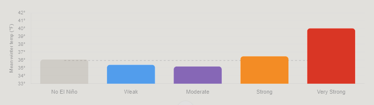
The stronger the El Niño, the warmer the temperatures. By itself, El Niño doesn’t mean much for our temperatures during the winter. Since ENSO records began in the 1950s, winters with El Niño end up about average at Atlantic City International Airport and the Sen. Frank S. Farley State Marina in Atlantic City.
However, when you look at the intensity of the El Niño, the pattern becomes clear.
Very Strong: 4.0 degrees warmer than average
Strong: 0.5 degrees warmer than average
Moderate: 0.7 degrees colder than average
Weak: 0.5 degrees colder than average.
Mean temperature between December and February for Atlantic City International Airport and Sen. Frank S. Farley State Marina in Atlantic City, based on the intensity of the El Nino (graphic is from Claude Artificial Intelligence, via NOAA data).
The stronger the El Niño, the warmer the temperatures. That’s because the Pacific jet stream – the river of air about 30,000 feet high that separates two airmasses – pushes into the Northeast. That means more opportunities for us to be south of the jet stream, taking in milder air.
Winter snow: One clear signal
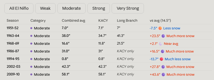
Like winter temperatures, using El Niño alone doesn’t produce a big trend in what snow could look like for a winter. Generally, it’s a little less snowy than average. However, when you look at the type of El Niño, there is a trend that screams off the chart.
When El Niño is in a moderate phase, it’s 13 inches snowier than average. For the South Jersey shore, that’s 25 to 30 inches of snow. Farther up the coast, that’s roughly 30 to 35 inches of snow.
Here’s the snow breakdown for Atlantic City International Airport and Long Branch, by El Niño phase.
Weak: 3.5 inches below average
Moderate: 13.2 inches above average
Strong: 3.4 inches below average
Very strong: 0.2 inches above average
Winter snowfall totals for the Jersey Shore, based on the intensity of the El Nino (graphic is from Claude Artificial Intelligence, via NOAA data)
The last two moderate El Niño winters were 2009-’10 and 2002-’03. Both brought plenty of snow, and winter storms. That included:
On Feb. 5-7, 2010, over 20 inches of snow fell roughly south of the Atlantic City Expressway. Meanwhile, New York City experienced less than 4 inches of snow.
A few days later, the Feb. 9-11 winter storm brought over half a foot of snow to the shore.
The Feb, 16-18, 2003, winter storm, known as the President’s Day II or PDII storm, dropped over 18 inches of snow on much of the Jersey Shore and ranks as the sixth strongest winter storm on NOAA’s Northeast Snowfall Impact Scale.
Moderate El Niños sit in a weather sweet spot for winter storms in New Jersey. They enhance the jet stream’s pattern in a way that funnels nor’easters up the coast without warming the region enough to flip precipitation to rain.
What if a ‘super’ El Niño arrives?
There is no guarantee that a very strong El Niño, or what people call a “super” El Niño, will come this winter. However, given the confidence of El Niño developing late this year, it’s worth exploring. Severe-Weather.Eu has a nice writeup on it.
If one does form, expect a mild winter with a low number of nor’easters. However, when nor’easters do hit, expect plenty of rain, wind or even snow.
FRIDAY’S FORECAST: It doesn’t feel like it in the morning but I promise you, dry weather and sunshine is on the way! We just got to wait for this warm front to cold. Warmth sticks around Easter weekend, too!
📹WEDNESDAY’S FORECAST | Happy Passover! We’re on our way to record-breaking warmth inland today. It’ll be a muuuccch different, colder story tomorrow, though. At least Easter weekend looks decent.
If your personal forecast feels uncertain this winter, support is available. See You Through It Counseling offers in-person and virtual therapy for children, adults, and couples. Invest in healing that lasts. Visit seeyouthroughitcounseling.com or call 856-335-1352.