📹TUESDAY’S FORECAST: March is still coming in like a lion. We got 70s today, the possibility of strong thunderstorms tomorrow and then a return to winter later this week! Tune in.
If your personal forecast feels uncertain this winter, support is available. See You Through It Counseling offers in-person and virtual therapy for children, adults, and couples. Invest in healing that lasts. Visit seeyouthroughitcounseling.com or call 856-335-1352.
📹SATURDAY’S FORECAST | Happy Spring Forward weekend! We’ll spring forward on the clocks and the temperatures this weekend. Plus, we have breaking weather news, too! Tune in…
Join us as we review the intense winter weather in New Jersey, including record snowfalls, blizzards, and drought conditions, with State Climatologist Dr. Dave Robinson. Discover the details behind the storms, snowpack, and what to expect in the coming months.
00:00 Introduction to February Weather Roundup 02:00 The February Nor’easter: Impact and Analysis 12:05 Snowpack and Its Effects on Weather Patterns 17:00 Winter Overview: Cold and Snowy Trends 22:55 Drought Conditions and Future Predictions 24:30 It was cold this winter, but…
Recap the month of weather that was. It’s all Jersey, with two of Jersey’s best weather guys. New Jersey State Climatologist Dr. Dave Robinson as well as Meteorologist Joe Martucci, owner of Cup A Joe Weather and Drone take you through the temperatures, rain, snow, coastal flooding and much more every episode. New episodes come out the beginning of every month.
My friend and fellow Certified Digital Meteorologist Emily Gracey puts together a kick butt podcast called Off The Radar. Every week, she does a 20-30 minute show about weather, climate, the environment and how we interact with it.
It’s not just some random podcast, either. Based in Charleston, SC Off The Radar won the National Headliner Award for “Best Information Podcast” in 2025.
Emily had me join the show to talk about our February 22-23 nor’easter in New Jersey. If you thought the 12 inch-plus snow was a lot here, Emily’s other guest, Meteorologist Chris Gloninger had over 30 inches of the white stuff in Cape Cod. Another weather friend of ours, Chris broke down the societal impacts of the heavy snow and wind. The storm there was a true emergency in that corner of the country.
📹WEDNESDAY’S FORECAST | Showers this week, but spring warmth is charging in this weekend—finally! Beaches will get skunked by the sea breeze, but even you’ll get 60s, too.
If your personal forecast feels uncertain this winter, support is available. See You Through It Counseling offers in-person and virtual therapy for children, adults, and couples. Invest in healing that lasts. Visit seeyouthroughitcounseling.comety= or call 856-335-1352.
📹TUESDAY’S FORECAST | Your generic weather app probably has the rain icon most days between now and Sunday.
That’s not true. Let’s time out the rain for you.
If your personal forecast feels uncertain this winter, support is available. See You Through It Counseling offers in-person and virtual therapy for children, adults, and couples. Invest in healing that lasts. Visit seeyouthroughitcounseling.com or call 856-335-1352.
Despite the Feb. 22-23 nor’easter bringing more snow than the Jan. 25 nor’easter, the days after the February brought more melted snow than in January. It’s not just become of warmer temperatures, either. Here are four reasons why.
WHERE DO SNOWFALL REPORTS COME FROM? | Honestly, you asked me a really good question. We always report the snow totals but don’t clearly explains HOW we actually get them.
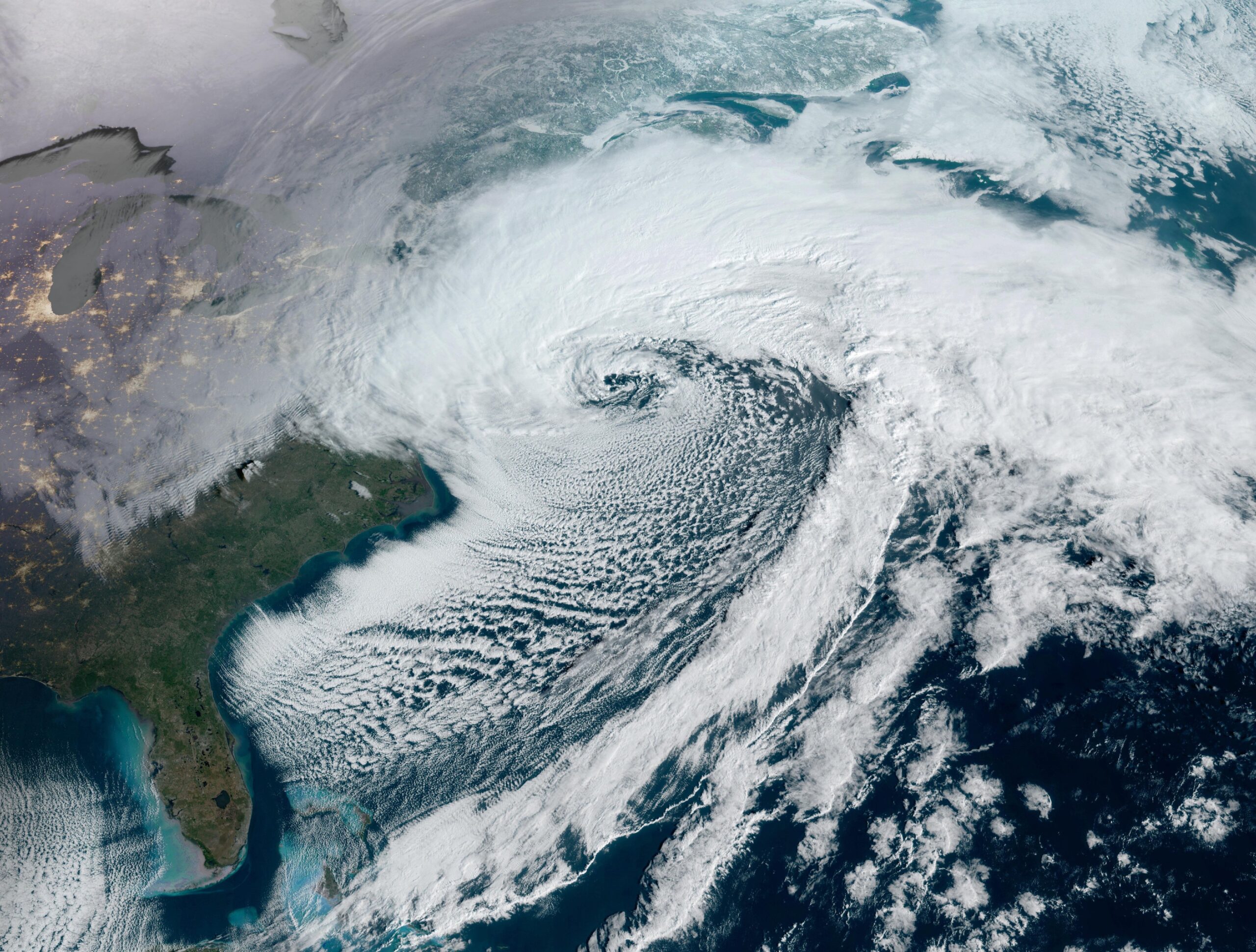
Just as a generational run of snowcover was starting to go away, a fresh nor’easter piled near historic snow amounts onto our lawns, beaches, cars and streets Feb. 22-23.
While nor’easters at the Jersey Shore are feared most for their tidal flooding, it was the snow that was most impactful this time.
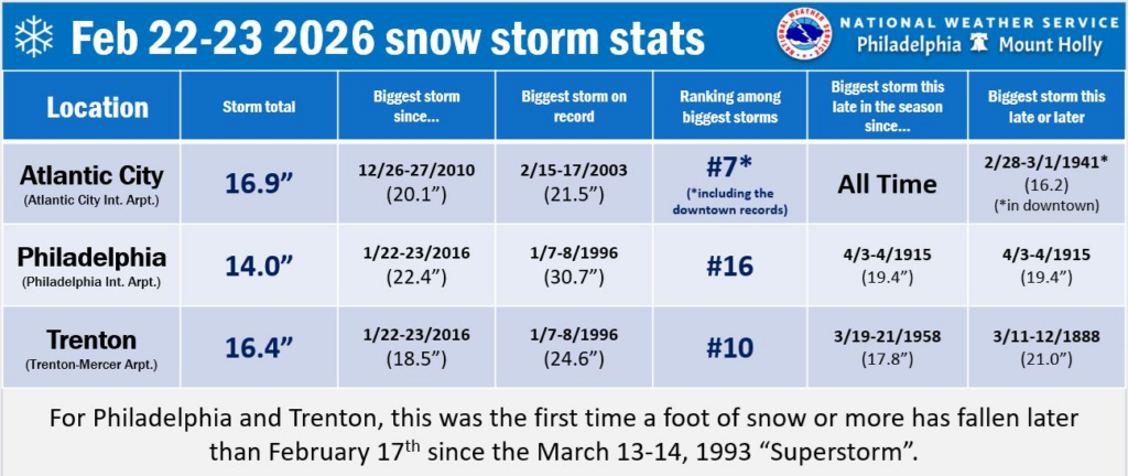
Nearly everywhere at the Jersey Shore had double-digit snow reports. Atlantic City International Airport picked up 16.9 inches of snow over the two-day stretch, according to the National Oceanic and Atmospheric Administration (NOAA). It was the biggest snowstorm this late in the winter season since records began in 1943, and the sixth largest two-day snowfall. Other Jersey Shore totals, measured in inches, included:
Cape May County
Ocean City: 16.0
Lower Twp.: 12.5
North Wildwood: 8.7
Atlantic County
Mays Landing: 19.0
Somers Point: 18.2
Egg Harbor Twp.: 18.0
Minotola: 17.0
Buena Vista Twp.: 16.5
Egg Harbor City: 15.3
Hammonton: 10.7
Ocean County
Jackson: 25.2
Lakewood: 24.0
Toms River: 22.0
Lakehurst: 21.8
Manahawkin: 19.0
Brick: 18.5
Ship Bottom: 18.0
Lanoka Harbor: 17.0
Tuckerton: 17.0
Monmouth County
Marlboro: 26.5
Middletown: 25.0
Freehold Twp.: 25.0
Snow receipts timeeeeeeeee. ❄️🧾❄️🧾
How'd we do at Cup A Joe Weather?
Feeling uncertain? NJ based See You Through It Counseling offers therapy for all ages. Call 856-335-1352. pic.twitter.com/Qy04a5Li7l
Here are seven reasons why this nor’easter will be talked about for years.
It was a bomb cyclone
It wasn’t just a nor’easter; it was a bomb cyclone, as the National Weather Service confirmed after it rapidly intensified through a process known as bombogenesis.
While sources vary, this storm saw a roughly 40 millibar drop in air pressure between Sunday morning and Monday morning. You need at least a 24-millibar drop in air pressure within 24 hours to be a “bomb.” This is the hallmark of a strong nor’easter.
It achieved that and then some.
It ‘generated’ its own cold air
It was mild in the days leading up to the nor’easter. High temperatures on Feb. 20-21 – Friday into Saturday – were in the upper 40s to low 50s. Even Sunday morning, temperatures were 35 to 40 degrees, and it was raining.
Then, as the storm underwent bombogenesis, there was a large amount of upward motion and air expansion. As the air expands, fewer molecules bump into each other, and you get cooling. In other words, it cooled down and rain turned to snow.
Temperatures hung on above freezing, with snow late Sunday afternoon not sticking much to roads and sidewalks. That happened later than I expected.
But once the sun set, temperatures sank below 32 and snow accumulated rapidly.
Light rain fell along the South Jersey Shore on Sunday night and Monday, but that was not often and the northern part of the shore stayed locked in as snow.
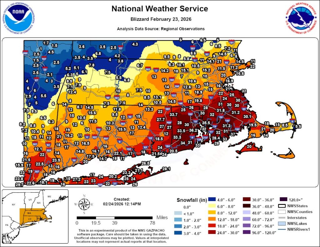
A multi-state ‘mega band’ of snow
The 15-inch or greater totals in most of Atlantic County and points north at the coastal counties were helped by heavy snow that fell for hours Monday morning.
The nor’easter generated two large bands of snow. We had the western one, which extended from western Massachusetts to the Hudson Valley and down the Garden State Parkway to Atlantic County.
If you were in it, you had snowfall rates of 1 to 2 inches per hour. It was roughly from around 2 a.m. to 10 a.m. So, if you do the math, that adds up.
While the storm underperformed my forecast Sunday afternoon, it made up for it Monday morning.
For what it’s worth, the eastern band was responsible for bringing Rhode Island’s largest snowstorm on record – 37.9 inches of snow fell in Providence, according to WPRI-TV and other outlets.
The snow was very wet
Heavy, wet snow piled up feet high in Avalon (courtesy of Avalon Public Works, a ShorelySafe client of our company)
The amount of precipitation that fell during this event ranged from 1.7 to 2.3 inches. We had a lot of snow, but a lot of liquid as well.
In New Jersey on average, 11 inches of snow falls for every inch of liquid. This was lower.
Woodbine likely had 18 inches of snow on 1.97 inches of liquid, according to the Community Collaborative Rain Hail and Snow Network (CoCoRaHS). That’s a snowfall ratio of roughly 9:1.
At Atlantic City International Airport, 16.9 inches of snow occurred with 1.97 inches of liquid. That’s a snow ratio of 8.6:1.
You noticed it. The snow was very hard to shovel or snowblow, and not just because of the amount. The snow stuck to my narrow windshield wipers. If the snow was fluffy, that wouldn’t happen.
Drought concerns eased
The 1.7 to 2.3 inches of liquid brought February’s precipitation back to average. That was much needed and reduced the risk of worsening drought going into wildfire season.
The United States Drought Monitor Feb. 26 update, which includes data through Feb. 24, showed an improvement in drought in parts of Cape May, Atlantic and Monmouth counties. It fact, drought was removed in Upper Cape May County and southern Atlantic County.
Probably the windiest snowstorm in decades
Atlantic City International Airport reported a 61 mph wind gusts at 3:13 a.m. Monday, Feb. 23. The National Weather Service said no major snowstorm or blizzard since 1978 had a gust as high as this one.
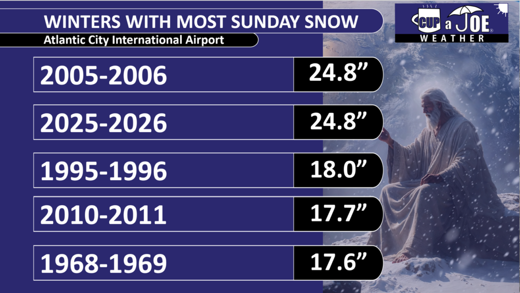
Record amount of Sunday winter snow
It may have taken divine intervention, but with 6.9 inches of snow at ACY Airport on Feb. 22, this winter is now tied with 2005-2006 for the winter with most Sunday snow on record.
Data via NOAA
With a brutally cold shot of air expected to begin in March, it’s still possible that 2025-2026 could claim the top spot for itself. Who said Sunday was a day of rest?
Thank You
I know you have other options for weather and appreciate that you stick here with Cup A Joe Weather. From Feb. 17-24, we had 2.005 million social impressions, 450,000 video views and a website audience of over 10,000 people.
A big thank you to our advertisers for making this possible. Without them, we can’t cover the shore like no where else.