Tag: snow

  • Why this snowy winter was NOT enough to cure NJ’s 2026 drought

    Why this snowy winter was NOT enough to cure NJ’s 2026 drought

    This article initially appeared in Shore Local News on April 30, 2026

    It’s unanimous, according to the state and federal agencies in charge of keeping track of drought conditions.

    Since November, New Jersey has been in drought, according to the state Department of Environmental Protection. Then, on April 14, the Jersey Shore was put into drought by the United States Drought Monitor, only to cover the entire state a week later.

    When I talk about this in my weather videos, or post about it on social media, some variation of the same question comes up.

    “How could the Jersey Shore be in drought? We had so much snow last winter.”

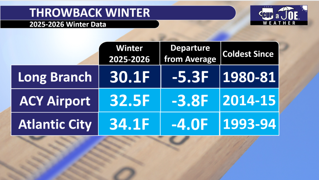
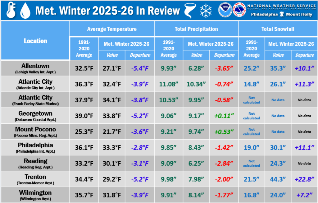
    While yes, we did have well-above-average snowfall (26.1 inches at Atlantic City International Airport, 18.6 inches in Margate, and 39.2 inches in Long Branch), but lots of snow doesn’t necessarily cure a drought. The correlation is pretty weak.

    Drought is defined as “a period of abnormally dry weather sufficiently long enough to cause a serious hydrological imbalance,” according to the American Meteorological Society. In other words, if the water going into the environment is less than the water being taken out of the environment (by humans, animals, evaporation, etc.) for a long period of time, you go into drought.

    Water comes into the environment by precipitation. Snow is precipitation, so is rain. However, on average in New Jersey, it takes 11 inches of snow to get 1 inch of precipitation. Meanwhile, 1 inch of rain equals 1 inch of precipitation.

    Snow to liquid ratio climatology. On average for New Jersey, it takes 10 to 11 inches of snow to produce one inch of precipitation. (via the National Weather Service)

    Here’s a look at how much snow, precipitation and average precipitation fell at Atlantic City International Airport from December to February:

    In December, there were 2.2 inches of snow, 3.03 inches of precipitation, vs. 3.76 inches of average precipitation.

    January saw 6.7 inches of snow, 3.78 inches of precipitation, vs. 3.44 inches of average precipitation.

    February recorded 17.2 inches of snow, 3.53 inches of precipitation, vs. 3.12 inches of average precipitation.

    Snowfall was about 75% above average during this time. Precipitation was about 5% below average.

    What about the snowpack?

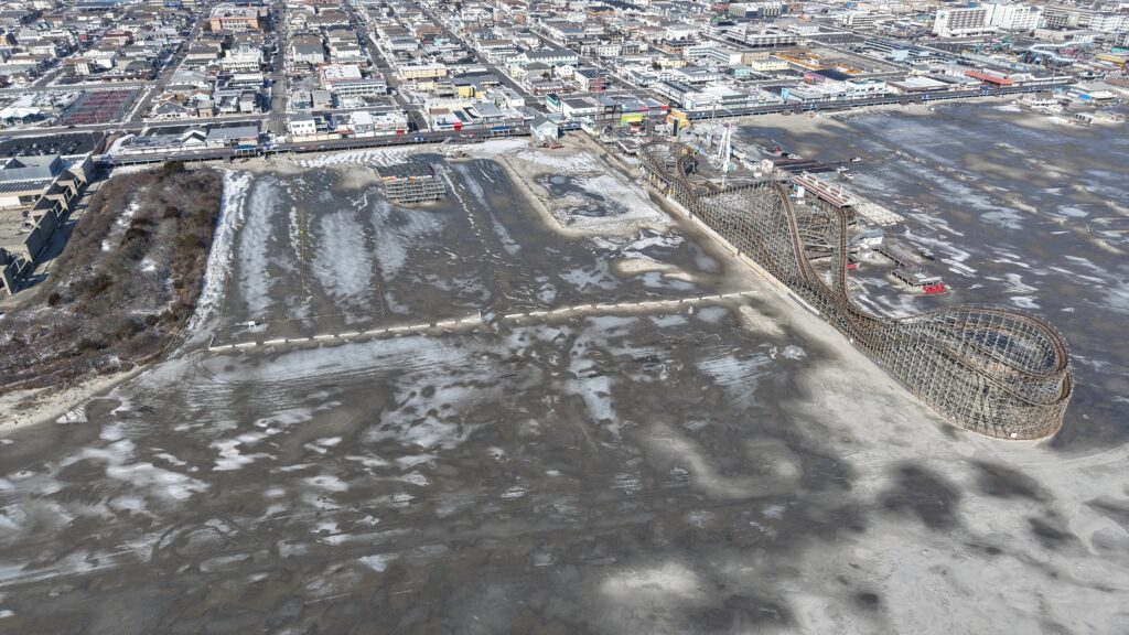
    This winter probably felt extra long because the snow was on the ground for so long. Twenty-nine days had at least 1 inch of snow covering the ground at Atlantic City International Airport, according to the National Oceanic and Atmospheric Administration, the sixth longest since records began in 1945.

    default

    Snow on the ground helps prevent drought from worsening. It allows for snow to slowly melt and seep into the ground. It also prevents the sun from pulling water from the ground and evaporating into the atmosphere.

    However, the snowpack wasn’t deep enough nor did it hang around long enough to have a significant impact on the drought.

    All things considered, it was a lack of precipitation in March that slid the Jersey Shore into a deeper drought.

    Drought outlook for NJ

    NOAA is forecasting that drought conditions will persist through the end of July, according to its April 30 update.

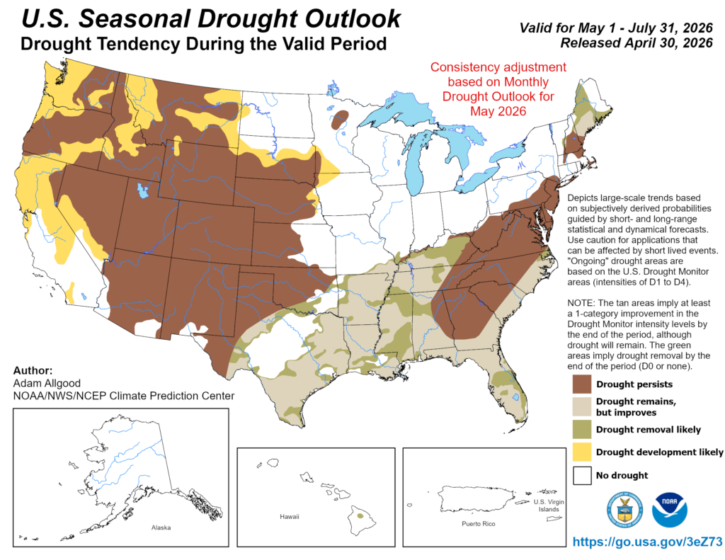
    Precipitation across the Jersey Shore, not just in a town or two, needs to average at least 5 inches during this time in order to drown out the drought. More than 4 inches of evaporation occurs during June and July.

    We’ll need a few coastal storms, or a very gloomy next month or two, in order to do that. If not, don’t be surprised to see mandatory water restrictions by the end of the summer.

  • How will developing El Niño impact NJ’s weather in 2026?

    How will developing El Niño impact NJ’s weather in 2026?

    Goodbye La Niña and hello El Niño – possibly a “super” El Niño.

    Expected between July and September, this shift in the Earth’s long-term weather patterns will define how we experience the upcoming hurricane season, as well as the snow and cold of next winter.

    Forecasters from the National Oceanic and Atmospheric Administration give El Niño a greater-than-60% chance of developing during the summer. By the fall, during the peak of hurricane season, it’s an 80% chance.

    By July, the chances of an El Nino developing are over 50% (via NOAA)

    El Niño or La Niña is part of the El Niño Southern Oscillation (ENSO). This refers to the water temperatures off the Equatorial Pacific Ocean, from roughly Peru westward 7,000 miles. When water temperatures are warmer than average, it’s El Niño. When it’s cooler than average, it’s La Niña.

    Via NOAA

    Meteorologists break this down into four different zones within the ENSO region. I won’t explain it much here, but where those warmer temperatures are this summer and beyond will make a slight difference in what our long-term forecast will be.

    Since the summer of 2024, we have been in La Niña. That typically means milder winters. However, both the 2024-2025 winter, and this past winter, were colder than average.

    The frozen tundra of snow and ice we experienced for weeks this past winter bucked the La Niña trend, too. For hurricane season, 2024 was more active than usual, while 2025 was about average. That checks out with a La Niña pattern.

    Let’s look at what El Niño will mean for both the 2026 hurricane season, and the 2026-2027 winter, plus what a “super” El Niño could mean for New Jersey.

    Quieter hurricane season likely

    When El Niño is present, hurricane activity in the Atlantic Hurricane Basin goes down; it’s that simple. The Atlantic Hurricane Basin averages 14 named storms – seven hurricanes including three major hurricanes (Category 3, 4 or 5) per season, per Colorado State University. Since 1990, there have been 11 hurricane seasons with El Niño. Seven were less active, while two were about average and two were more active.

    More than likely, this hurricane season will be as active or less active than average. With a 24% chance of the eye of a tropical storm or hurricane being within 50 miles of the Jersey Shore, that number should be lower as well. Hurricane season officially runs from June 1 to Nov. 30.

    During El Niño, there is stronger windshear in the tropical Atlantic Ocean. Windshear is a change of wind direction or speed as you go up from the surface. This, in short, rips apart developing cyclones.

    Winter temperatures

    The stronger the El Niño, the warmer the temperatures. By itself, El Niño doesn’t mean much for our temperatures during the winter. Since ENSO records began in the 1950s, winters with El Niño end up about average at Atlantic City International Airport and the Sen. Frank S. Farley State Marina in Atlantic City.

    However, when you look at the intensity of the El Niño, the pattern becomes clear.

    Very Strong: 4.0 degrees warmer than average

    Strong: 0.5 degrees warmer than average

    Moderate: 0.7 degrees colder than average

    Weak: 0.5 degrees colder than average.

    Mean temperature between December and February for Atlantic City International Airport and Sen. Frank S. Farley State Marina in Atlantic City, based on the intensity of the El Nino (graphic is from Claude Artificial Intelligence, via NOAA data).

    The stronger the El Niño, the warmer the temperatures. That’s because the Pacific jet stream – the river of air about 30,000 feet high that separates two airmasses – pushes into the Northeast. That means more opportunities for us to be south of the jet stream, taking in milder air.

    Winter snow: One clear signal

    Like winter temperatures, using El Niño alone doesn’t produce a big trend in what snow could look like for a winter. Generally, it’s a little less snowy than average. However, when you look at the type of El Niño, there is a trend that screams off the chart.

    When El Niño is in a moderate phase, it’s 13 inches snowier than average. For the South Jersey shore, that’s 25 to 30 inches of snow. Farther up the coast, that’s roughly 30 to 35 inches of snow.

    Here’s the snow breakdown for Atlantic City International Airport and Long Branch, by El Niño phase.

    Weak: 3.5 inches below average

    Moderate: 13.2 inches above average

    Strong: 3.4 inches below average

    Very strong: 0.2 inches above average

    Winter snowfall totals for the Jersey Shore, based on the intensity of the El Nino (graphic is from Claude Artificial Intelligence, via NOAA data)

    The last two moderate El Niño winters were 2009-’10 and 2002-’03. Both brought plenty of snow, and winter storms. That included:

    The Dec. 19 to 21, 2009 winter storm, which brought double-digit snowfall across the entire Jersey Shore.

    On Feb. 5-7, 2010, over 20 inches of snow fell roughly south of the Atlantic City Expressway. Meanwhile, New York City experienced less than 4 inches of snow.

    A few days later, the Feb. 9-11 winter storm brought over half a foot of snow to the shore.

    The Feb, 16-18, 2003, winter storm, known as the President’s Day II or PDII storm, dropped over 18 inches of snow on much of the Jersey Shore and ranks as the sixth strongest winter storm on NOAA’s Northeast Snowfall Impact Scale.

    Moderate El Niños sit in a weather sweet spot for winter storms in New Jersey. They enhance the jet stream’s pattern in a way that funnels nor’easters up the coast without warming the region enough to flip precipitation to rain.

    What if a ‘super’ El Niño arrives?

    There is no guarantee that a very strong El Niño, or what people call a “super” El Niño, will come this winter. However, given the confidence of El Niño developing late this year, it’s worth exploring. Severe-Weather.Eu has a nice writeup on it.

    If one does form, expect a mild winter with a low number of nor’easters. However, when nor’easters do hit, expect plenty of rain, wind or even snow.

  • Cold and Snowy, for real: Winter 2025-26 at the Jersey Shore

    Cold and Snowy, for real: Winter 2025-26 at the Jersey Shore

    Yes, it was a cold and snowy winter at the Jersey Shore, for real. Every month had at least one snowstorm, the biggest one being the Feb. 22-23 nor’easter, which the National Weather Service officially classified as a blizzard on March 6.

    Climatological winter ended on Feb. 28, but winter cold isn’t done yet as a parting shot of cold air is likely during the middle of March.

    Let’s look back at a winter to remember, because we may not get something like this for a long time. (Most of the information here is taken from my Monthly Weather Roundup show with New Jersey State Climatologist Dave Robinson).

    It was a persistently cold and snowy winter for the Jersey Shore. December, January and February were all colder than average, with snow events each month. Temperatures were in the coldest third going back to 1895. However, it was not a top-10 or record-breaking winter because winters have warmed over time.

    Atlantic City International Airport had its coldest winter since 2014-2015. Go to the beaches and the cold was more impressive. The Sen. Frank S. Farley State Marina in Atlantic City had its chilliest winter since 1993-’94, staying 4 degrees below the 1991-2020 average.

    Up the coast, Long Branch lived through its coldest winter since 1980-’81.

    Each county in our region reported above-average snowfall. Typically, the Jersey Shore was 10 to 20 inches above seasonal snowfall. There was, however, a noteworthy jump in totals once you went to the northern part of the Jersey Shore, as follows:

    • Cape May: Woodbine (25.0 inches)
    • Atlantic: Hamilton (29.4 inches)
    • Ocean: Manchester (42.4 inches)
    • Monmouth: Red Bank (49.6 inches)

    For snow lovers, it was a great winter.

    The drought continues

    Despite the heavy snow, it stayed dry overall. Precipitation (including melted snow) was below normal every month. Drought warnings continued from the New Jersey Department of Environmental Protection, with low groundwater levels persisting.

    We need more rain or snow soon to avoid worse drought problems this summer.

    February nor’easter

    The biggest story from February was the nor’easter that hit Feb. 22-23. This storm dropped heavy snow up and down the Shore. Almost everywhere saw double-digit snowfall totals of 10 inches or more.

    The storm hugged the coast so eastern New Jersey got the heaviest snow. It stayed mostly snow without switching to rain or ice in many places, which made it feel more like a classic New Jersey winter storm.

    It turns out that it was officially a blizzard. It met the criteria of 35 mph or greater winds, and visibility under a quarter of a mile from falling or blowing snow lasting three hours or more.

    Interestingly, the slushy cold ocean may have brought higher shore snow totals. Mid-latitude cyclones like this nor’easter intensify along boundaries of cold and mild air. With the cold ocean, the storm had to go out farther east in search of the warmer Gulf Stream.

    Sunday snow record

    Atlantic City International Airport tied a record for the most snow on a Sunday with 19.6 inches, matching a previous record.

    Is it luck? Maybe. Is it a shame? Maybe. That’s up to you to decide.

    Lots of snow, but not a record

    The Jan. 25 nor’easter and the weather to follow was a unique set of circumstances that led to snow staying on the ground for weeks, literally.

    Atlantic City International Airport had the fourth longest stretch with at least an inch of snow on the ground, according to the National Weather Service. Snow stayed on the ground from Jan. 25 to Feb. 14. Up the coast, in Long Branch, the streak was for 27 days.

    However, neither of these were records. ACY’s longest stretch was February – March, 2003, with 26 straight days of snow cover. The record in Long Branch is more than twice as long as what we just experienced – 58 days of snow cover made the city look like a glacier from Dec. 23, 1947, to Feb. 18, 1948.

    Going a step further, when you look at the greatest number of days with snow cover in a climatological winter (December to February), Atlantic City International Airport ranked fourth, and Long Branch ranked seventh. Thanks to Ray Martin at the National Weather Service in Mount Holly for that.

    A winter to remember

    Overall, the winter of 2025-2026 reminded people of older, snowier New Jersey winters, but it wasn’t the most extreme ever. It was just reliably cold and white – a fun one for snow fans, but we still need more water to end the dry spell.

    Ice and snow covered the beach in Wildwood nine days after the January nor’easter. Photo taken on Feb. 4, 2026 by Joe Martucci.

    Joe Martucci, a Certified Broadcast Meteorologist and Digital Meteorologist, is the President and Director of Meteorology for Cup A Joe Weather and Drone. You can connect with him at cupajoe.sparkable.opalstacked.com/.

  • Thursday’s weather: 60s this morning, snow this evening?! 😵

    Thursday’s weather: 60s this morning, snow this evening?! 😵

    📹THURSDAY’S FORECAST: Weather whiplash! Warm this morning, SNOW this evening?! Yeah, it’s possible. There will definitely be a cold rain starting around 12PM though.

    Why settle for big chains? Choose Just4Wheels’ family-owned locations all across NJ! Rent brand-new sedans, passenger vans, box trucks and more today! Visit www.just4wheels.com or call 877-650-3500.

  • ❌It is not that wet for the rest of the week in NJ, I promise

    ❌It is not that wet for the rest of the week in NJ, I promise

    THURSDAY’S FORECAST | Despite what the generic weather app says, the rest of the week will not be all that wet. The Cape May Bubble will be in effect, with the driest weather. Our spring fever is still on track to start Sunday! See how warm the beaches and inland areas will get here.

    Our 24×7 Jersey Shore Weather Channel: https://www.youtube.com/watch?v=lGssDGu6xk0
    Jolt your brand, advertise here: joe@cupajoe.live

  • ☃️COLD and SNOWY, for real | February 2026 and Winter Monthly Weather Roundup

    ☃️COLD and SNOWY, for real | February 2026 and Winter Monthly Weather Roundup

    Join us as we review the intense winter weather in New Jersey, including record snowfalls, blizzards, and drought conditions, with State Climatologist Dr. Dave Robinson. Discover the details behind the storms, snowpack, and what to expect in the coming months.

    00:00 Introduction to February Weather Roundup
    02:00 The February Nor’easter: Impact and Analysis
    12:05 Snowpack and Its Effects on Weather Patterns
    17:00 Winter Overview: Cold and Snowy Trends
    22:55 Drought Conditions and Future Predictions
    24:30 It was cold this winter, but…


    Recap the month of weather that was. It’s all Jersey, with two of Jersey’s best weather guys. New Jersey State Climatologist Dr. Dave Robinson as well as Meteorologist Joe Martucci, owner of Cup A Joe Weather and Drone take you through the temperatures, rain, snow, coastal flooding and much more every episode. New episodes come out the beginning of every month.

    Cup A Joe Website: www.cupajoe.live
    NJ Climatologist’s Office: www.njclimate.org

  • Off The Radar podcast interviews Joe Martucci on February nor’easter

    Off The Radar podcast interviews Joe Martucci on February nor’easter

    My friend and fellow Certified Digital Meteorologist Emily Gracey puts together a kick butt podcast called Off The Radar. Every week, she does a 20-30 minute show about weather, climate, the environment and how we interact with it.

    It’s not just some random podcast, either. Based in Charleston, SC Off The Radar won the National Headliner Award for “Best Information Podcast” in 2025.

    Emily had me join the show to talk about our February 22-23 nor’easter in New Jersey. If you thought the 12 inch-plus snow was a lot here, Emily’s other guest, Meteorologist Chris Gloninger had over 30 inches of the white stuff in Cape Cod. Another weather friend of ours, Chris broke down the societal impacts of the heavy snow and wind. The storm there was a true emergency in that corner of the country.

    Listen on Apple
    Listen on Spotify
    Listen on Audible
    Listen on YouTube

  • 🌻SPRING is in the air! Rain, not snow and inland 60s are coming.

    🌻SPRING is in the air! Rain, not snow and inland 60s are coming.

    📹TUESDAY’S FORECAST | Your generic weather app probably has the rain icon most days between now and Sunday.

    That’s not true. Let’s time out the rain for you.

    If your personal forecast feels uncertain this winter, support is available. See You Through It Counseling offers in-person and virtual therapy for children, adults, and couples. Invest in healing that lasts. Visit seeyouthroughitcounseling.com or call 856-335-1352.

  • 4 reasons why snow is melting fast after February’s NJ nor’easter

    4 reasons why snow is melting fast after February’s NJ nor’easter

    Despite the Feb. 22-23 nor’easter bringing more snow than the Jan. 25 nor’easter, the days after the February brought more melted snow than in January. It’s not just become of warmer temperatures, either. Here are four reasons why.

    Our 24×7 Jersey Shore Weather Channel: https://www.youtube.com/watch?v=lGssDGu6xk0
    Jolt your brand, advertise here: joe@cupajoe.live

  • It’ll be ANOTHER Sunday with snow, but I promise it’s not a big deal

    It’ll be ANOTHER Sunday with snow, but I promise it’s not a big deal

    SATURDAY’S FORECAST | Another weekend, another Sunday with snow! However, it’s not a big deal, trust me. Enjoy the mild weather today and even milder weather coming up next weekend. 😉

    Our 24×7 Jersey Shore Weather Channel: https://www.youtube.com/watch?v=lGssDGu6xk0
    Jolt your brand, advertise here: joe@cupajoe.live