WHERE DO SNOWFALL REPORTS COME FROM? | Honestly, you asked me a really good question. We always report the snow totals but don’t clearly explains HOW we actually get them.
Just as a generational run of snowcover was starting to go away, a fresh nor’easter piled near historic snow amounts onto our lawns, beaches, cars and streets Feb. 22-23.
While nor’easters at the Jersey Shore are feared most for their tidal flooding, it was the snow that was most impactful this time.
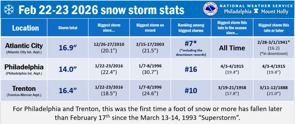
Nearly everywhere at the Jersey Shore had double-digit snow reports. Atlantic City International Airport picked up 16.9 inches of snow over the two-day stretch, according to the National Oceanic and Atmospheric Administration (NOAA). It was the biggest snowstorm this late in the winter season since records began in 1943, and the sixth largest two-day snowfall. Other Jersey Shore totals, measured in inches, included:
Cape May County
Ocean City: 16.0
Lower Twp.: 12.5
North Wildwood: 8.7
Atlantic County
Mays Landing: 19.0
Somers Point: 18.2
Egg Harbor Twp.: 18.0
Minotola: 17.0
Buena Vista Twp.: 16.5
Egg Harbor City: 15.3
Hammonton: 10.7
Ocean County
Jackson: 25.2
Lakewood: 24.0
Toms River: 22.0
Lakehurst: 21.8
Manahawkin: 19.0
Brick: 18.5
Ship Bottom: 18.0
Lanoka Harbor: 17.0
Tuckerton: 17.0
Monmouth County
Marlboro: 26.5
Middletown: 25.0
Freehold Twp.: 25.0
Snow receipts timeeeeeeeee. ❄️🧾❄️🧾
How'd we do at Cup A Joe Weather?
Feeling uncertain? NJ based See You Through It Counseling offers therapy for all ages. Call 856-335-1352. pic.twitter.com/Qy04a5Li7l
Here are seven reasons why this nor’easter will be talked about for years.
It was a bomb cyclone
It wasn’t just a nor’easter; it was a bomb cyclone, as the National Weather Service confirmed after it rapidly intensified through a process known as bombogenesis.
While sources vary, this storm saw a roughly 40 millibar drop in air pressure between Sunday morning and Monday morning. You need at least a 24-millibar drop in air pressure within 24 hours to be a “bomb.” This is the hallmark of a strong nor’easter.
It achieved that and then some.
It ‘generated’ its own cold air
It was mild in the days leading up to the nor’easter. High temperatures on Feb. 20-21 – Friday into Saturday – were in the upper 40s to low 50s. Even Sunday morning, temperatures were 35 to 40 degrees, and it was raining.
Then, as the storm underwent bombogenesis, there was a large amount of upward motion and air expansion. As the air expands, fewer molecules bump into each other, and you get cooling. In other words, it cooled down and rain turned to snow.
Temperatures hung on above freezing, with snow late Sunday afternoon not sticking much to roads and sidewalks. That happened later than I expected.
But once the sun set, temperatures sank below 32 and snow accumulated rapidly.
Light rain fell along the South Jersey Shore on Sunday night and Monday, but that was not often and the northern part of the shore stayed locked in as snow.
A multi-state ‘mega band’ of snow
The 15-inch or greater totals in most of Atlantic County and points north at the coastal counties were helped by heavy snow that fell for hours Monday morning.
The nor’easter generated two large bands of snow. We had the western one, which extended from western Massachusetts to the Hudson Valley and down the Garden State Parkway to Atlantic County.
If you were in it, you had snowfall rates of 1 to 2 inches per hour. It was roughly from around 2 a.m. to 10 a.m. So, if you do the math, that adds up.
While the storm underperformed my forecast Sunday afternoon, it made up for it Monday morning.
For what it’s worth, the eastern band was responsible for bringing Rhode Island’s largest snowstorm on record – 37.9 inches of snow fell in Providence, according to WPRI-TV and other outlets.
The snow was very wet
Heavy, wet snow piled up feet high in Avalon (courtesy of Avalon Public Works, a ShorelySafe client of our company)
The amount of precipitation that fell during this event ranged from 1.7 to 2.3 inches. We had a lot of snow, but a lot of liquid as well.
In New Jersey on average, 11 inches of snow falls for every inch of liquid. This was lower.
Woodbine likely had 18 inches of snow on 1.97 inches of liquid, according to the Community Collaborative Rain Hail and Snow Network (CoCoRaHS). That’s a snowfall ratio of roughly 9:1.
At Atlantic City International Airport, 16.9 inches of snow occurred with 1.97 inches of liquid. That’s a snow ratio of 8.6:1.
You noticed it. The snow was very hard to shovel or snowblow, and not just because of the amount. The snow stuck to my narrow windshield wipers. If the snow was fluffy, that wouldn’t happen.
Drought concerns eased
The 1.7 to 2.3 inches of liquid brought February’s precipitation back to average. That was much needed and reduced the risk of worsening drought going into wildfire season.
The United States Drought Monitor Feb. 26 update, which includes data through Feb. 24, showed an improvement in drought in parts of Cape May, Atlantic and Monmouth counties. It fact, drought was removed in Upper Cape May County and southern Atlantic County.
Probably the windiest snowstorm in decades
Atlantic City International Airport reported a 61 mph wind gusts at 3:13 a.m. Monday, Feb. 23. The National Weather Service said no major snowstorm or blizzard since 1978 had a gust as high as this one.
Record amount of Sunday winter snow
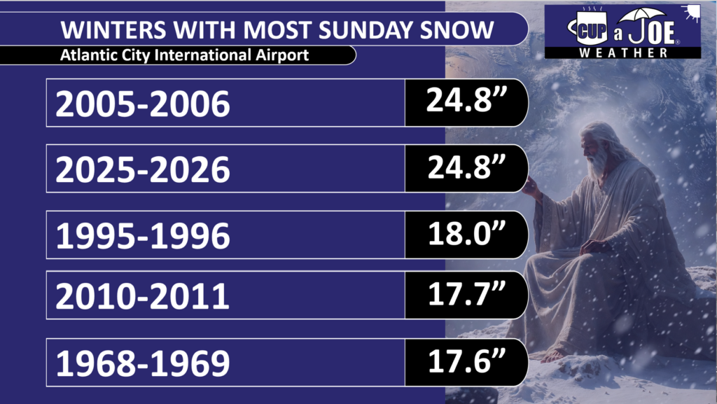
It may have taken divine intervention, but with 6.9 inches of snow at ACY Airport on Feb. 22, this winter is now tied with 2005-2006 for the winter with most Sunday snow on record.
Data via NOAA
With a brutally cold shot of air expected to begin in March, it’s still possible that 2025-2026 could claim the top spot for itself. Who said Sunday was a day of rest?
Thank You
I know you have other options for weather and appreciate that you stick here with Cup A Joe Weather. From Feb. 17-24, we had 2.005 million social impressions, 450,000 video views and a website audience of over 10,000 people.
A big thank you to our advertisers for making this possible. Without them, we can’t cover the shore like no where else.
📽️WEDNESDAY’S FORECAST | Another day, another snow! This time it’s only lasting for an hour, and if you’re south of Toms River, you’re mixing with rain.
Want even more snow? Look at Monday. I have some thoughts on a mini-coastal storm.
If your personal forecast feels uncertain this winter, support is available. See You Through It Counseling offers in-person and virtual therapy for children, adults, and couples. Invest in healing that lasts. Visit seeyouthroughitcounseling.com or call 856-335-1352.
📽️TUESDAY’S FORECAST | All is clear for the big dig today! Mother Nature ain’t helping us dig out, though. Highs will be at or below freezing.
2 more rounds of wintry weather are on the way. I promise, though, it’s not like this Sunday-Monday.
If your personal forecast feels uncertain this winter, support is available. See You Through It Counseling offers in-person and virtual therapy for children, adults, and couples. Invest in healing that lasts. Visit seeyouthroughitcounseling.com or call 856-335-1352.
The snow is finally coming to an end, and the sounds of blowers and plows echo through the towns. Schools are announcing closures for a second day in a row, and I’m sure many kitchens smell like hot chocolate and freshly baked cookies.
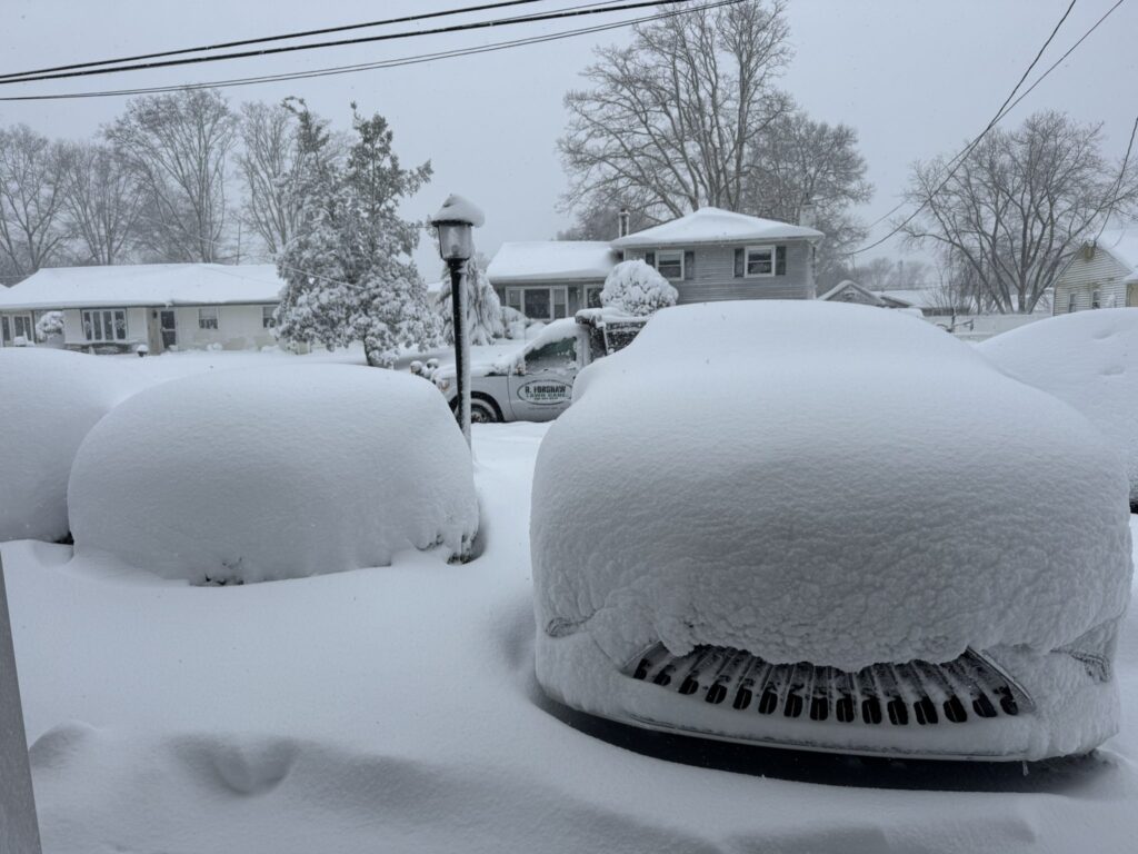
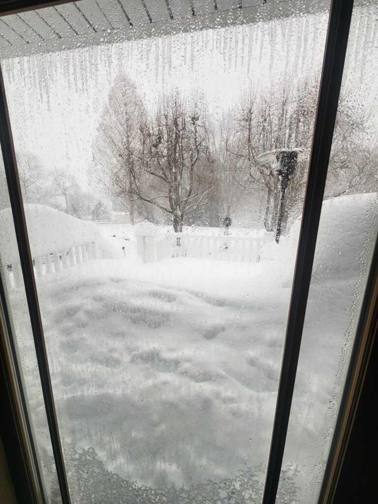
It’s been a long time since we had a storm of this magnitude. Up to two feet of snow fell in parts of the Jersey Shore, especially Monmouth County, where there are reports over the two-foot mark. Power outages across the state are starting to drop. Right now, there are over 97,000 customers without power in the Garden State.
NJ Transit is slowly resuming some services on modified schedules; however, rail, bus, and Access Link are still suspended. Newark Light Rail resumed at 4PM on a Sunday schedule.
Temperatures tonight will drop down to the 20s, but wind chills will be in the single digits and teens, so make sure you bundle up if you are going to be outside digging out from the incredible, unforgettable Blizzard of 2026.
3PM Monday
We’re in the 4th quarter of our nor’easter. Snow is STILL coming down in some of the beach towns and gusts will continue to whip. Monmouth-Ocean counties have plenty of 20″ snow reports. Let’s wrap up this storm and look ahead to more snow (yup).
2PM Monday
The mandatory travel restriction has ended; however, travel is still very dangerous as the snow continues to fall around the Jersey Shore region. Non-emergency travel is highly discouraged. There are still restrictions on commercial vehicle travel, and the 35 MPH speed restriction remains in place on Interstate and State highways, according to the NJDOT.
The Travel Restriction has been lifted.
Motorists are still encouraged to avoid unnecessary travel as hazardous conditions persist in some areas. Crews remain on the roads.
We still have a few more hours to go before the snow showers come to an end. The last of the snow is expected to be moving off the coast between 4 to 6PM.
The effects of the blizzard will go beyond this evening. Temperatures tonight will fall to the 20s, but wind gusts up to 25-30 MPH will make it feel like the upper single digits and teens, causing everything to freeze. Many school districts have already closed for Tuesday, and that list is likely to grow dramatically.
12PM Monday
As of 12PM, a heavy band of snow is continuing to hammer Monmouth and Ocean counties. This band extends up into the Newark area and southern parts of Bergen County as well. To the northwest, of the I-95 corridor, the snow is still falling, but at a lighter rate.
Over 17″ of snow burying Somers Point, NJ on Monday Morning (Dan Forshaw)
Here are a some important updates:
NJ Transit service remains suspended until further notice. The transit service says it will remain suspended until conditions allow for “gradual resumption” of service.
The mandatory travel restriction that was extended until noon is set to expire. So far, there has not been an announcement on if it will be extended again. Travel remains treacherous, especially in the eastern half of the state.
Commercial vehicle restrictions remain in place on multiple NJ highways.
As of this writing, we are experiencing our afternoon round of minor coastal flooding. Be prepared!
Lastly, over 128,000 customers are without power in New Jersey.
10AM Monday
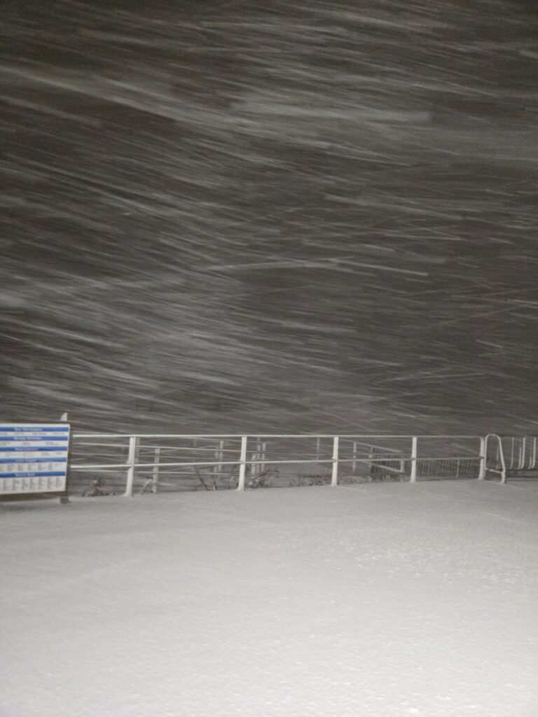
The entire Garden State is waking up to a crippling blizzard that continues to bring heavy snowfall rates to the Jersey Shore this morning. These are some of the snowfall reports received by the NWS so far:
ACY – 14.5” @ 7AM
North Wildwood – 8.7” @ 7:54AM
Freehold – 24.2” @ 7:45AM
Howell – 18.2” @ 6:45AM
Lakewood – 16” @ 7AM
Massive amounts of snow on the deck! (Jon Rocco)
New Jersey Governor Mikie Sherrill has extended the mandatory travel restriction until 12PM, however, snow showers will continue into a good part of the afternoon until the last of the storm finally moves off the coast from 3-6PM.
The entire NJ Transit system also remains suspended this morning.
930PM Sunday
Intense snow bands continue to slam the region tonight! Dan Forshaw reported a total of 5” of snow so far as of 8:55PM in Somers Point, where he says 1” of snow accumulated in the 45 minutes preceding that.
Based on reports we have received so far, it is clear that the forecast this storm will easily verify. A trained spotter in Howell already reported 9.4” of snow as of 9PM.
Here are some important reminders:
Mandatory travel restriction in place until 7AM Monday for state, municipal, county, and interstate roadways (except the NJTPK)
NJ Transit service is now suspended
Coastal flooding will peak at around midnight tonight with MODERATE flood stage
Heavy snowfall rates will continue into Monday Morning, eventually becoming lighter mid-to-late morning. The snow doesn’t completely shut down until 3-6PM.
830PM SUNDAY
Moderate to heavy snow continues to hammer the Jersey Shore. These are a couple of the snowfall reports coming so far on social media:
Colts Neck – 6.8” around 8PM, with close to 8 inches on the grass
Somers Point – 4” as of 8:10PM
Heavy snow falling in Belmar, NJ (@feelthemess on X)
The NWS has also received reports of 6” of snow at 8PM in Freehold, 4.5” in Ventnor City shortly before 8PM, 4.2” in Keyport, and 5.8” in Brick. We are well on our way to having over (potentially well over) a foot of snow on the ground once the sun rises on Monday!
Winds are also increasing. The NJ Weather Network station in Little Egg Harbor Township has measured a wind gust up to 53 MPH so far. According to poweroutage.us, there are over 20,000 customers without power in the state as of around 8:30PM.
7PM SUNDAY
Snow continues to pick up! We have had some heavier bands push through the southern and central part of the state over the last two hours. Widespread totals generally range between 1 to 3 inches across the better part of the state, with locally higher totals reaching as much as 5 inches in places like Colts Neck (Monmouth County).
Around 6:30 p.m., I measured just shy of two inches on my snow board. However, my wife has measured even more in our front yard (more like 3.5 inches).
With conditions set to get worse over the next few hours, mandatory travel restrictions have been put in place.
As mentioned before, this snow is wet and heavy. It’s legit plaster, already weighing down the branches of our smaller trees. Our lights have flickered a few times already, so power outages are likely for sure.
With that, this heavy snow also poses a big health risk for those with cardiac issues and for those over the age of 60. Please, please, PLEASE do not try to shovel this snow. If you could find or pay someone younger to shovel, or use a snowblower, that would be a much safer option.
Stay safe everyone!
If you missed it, here’s the link to the latest Live chat:
This snow is thiccck! And by this, I mean wet and heavy. Just took a walk down our block to one of the main roads in town. Plows and salt trucks are out, but that snow is accumulating- and roads are slippery. At least in my neck of the woods.
It’s one of those snows you need a face mask- and waterproof gear is a must, too. My face was soaked in a matter of minutes (and so were my hands).
Snowfall totals across the state continue to trickle in. It looks like most places south of the Raritan are reporting somewhere between 1 to 2 inches of snow. Other reported totals farther north and west are locally less, but still range between a half-inch to an inch. I’ll take the first snowfall total measurement at our place before the 7 p.m. Live Update.
Measuring wind speeds during the Blizzard of 2026. (Shawnie Caslin Martucci)
Winds are continuing to pick up, too. I took our handheld anemometer for a spin, and got a gust of 16.7 mph. As this storm strengthens, we will see those gusts intensify tonight. Since strong winds and heavy wet snow could take down power trees/tree limbs and power lines, power outages are possible. So, now would be great time to change up those electronic devices- and make sure the batteries in your flashlights are still good, too.
Once again, make sure to submit your photos to www.cupajoe.live/submit
330 PM SUNDAY
Snow is now covering the entire state, with moderate to heavy bands pushing up through southeastern NJ. Winds are also beginning to pick up some more, too. Between now and the next update, I’ll start taking some readings on my handheld anemometer.
Speaking for where I am located in Monmouth County, snow is now accumulating on roads and surfaces. Only received three snowfall totals across the state so far from the National Weather Service (NWS). Somers Point in Atlantic County reported 1.7 inches, with Galloway Township reporting a half inch over the last hour or so. In northwest NJ, a third report of 0.3 inches was reported in Ledgewood.
A good portion of NJ is now seeing those flakes fly! Within the next hour or so, we’ll see a complete changeover to snow.
Looking at some of our live cams (NJDOT) down in Cape May County, we can see snow already accumulating on roads, slowing down travel. Snow is also beginning to stick to grassy surfaces in Monmouth County, too.
Moderate snowfall will continue through this afternoon before conditions begin to deteriorate this evening into tonight. High winds combined with heavy snow will create blizzard conditions, making for very dangerous travel conditions. That said, now is the time to wrap up any of those last-minute errands.
Make sure to submit your photos to www.cupajoe.live/submit
We’ll be back at 3:30 p.m. for another update!
130PM SUNDAY
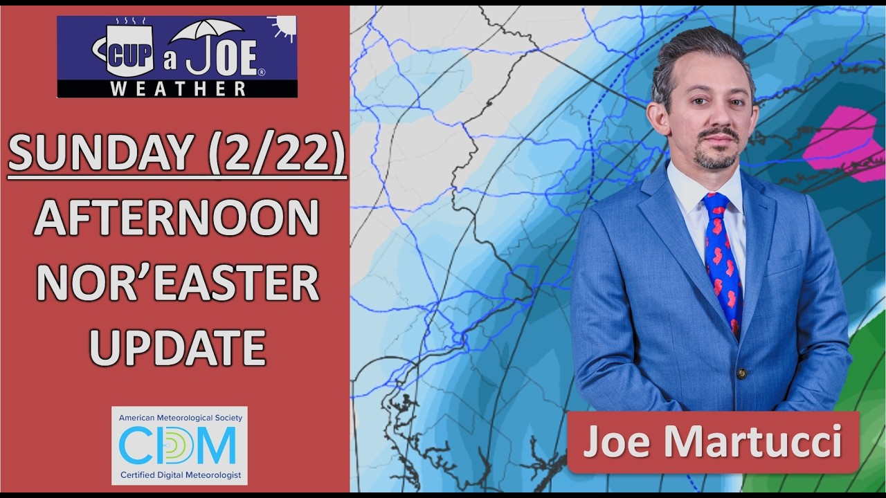
SUNDAY AFTERNOON UPDATE | Yes, rain’s holding on longer than I thought but we’re flipping over to snow from north to south as you read this. We’re still on pace for over 12″ of snow for most of NJ.
Also, the tidal flooding forecast has gone UP. This now looks to be similar tides tonight to what we had during Hurricane Erin last August.
📽️We’re in the 4th quarter of our nor’easter. Snow is STILL coming down in some of the beach towns and gusts will continue to whip. Monmouth-Ocean counties have plenty of 20″ snow reports. Let’s wrap up this storm and look ahead to more snow (yup).
Two to three inches of precipitation will be in this snowfall. Think about how heavy it is to carry a water cooler. Now try to move that weight off your driveway, your sidewalks and parking lots. It’s hard. Use a snowblower or hire a contractor if you’re able in order to lessen the risk to you.
SUNDAY AFTERNOON UPDATE | Yes, rain’s holding on longer than I thought but we’re flipping over to snow from north to south as you read this. We’re still on pace for over 12″ of snow for most of NJ.
Also, the tidal flooding forecast has gone UP. This now looks to be similar tides tonight to what we had during Hurricane Erin last August.