
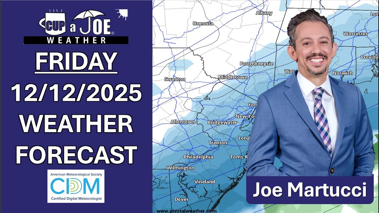
WEDNESDAY’S FORECAST | It’s merry and bright for Christmas Eve but that’ll change. A winter storm is on for Kwanzaa and Boxing Day and this will bring an ol’ fashioned slop fest to the Jersey Shore. Snow, sleet, freezing rain and rain will be around. Here’s what I know so far.
Follow my work: www.cupajoe.live
Jolt your brand, advertise with me: joe@cupajoe.live
Tag: snow
-

WINTRY MESS! First look NJ snow forecast for Friday night – Saturday system.
-
Recap Sunday’s Snowy Winter Storm with us at the Jersey Shore
4:45PM
SUNDAY NIGHT FORECAST UPDATE: The snow has settled and it piled high in the northern part of the Jersey Shore. Jackson picked up 8.6″ of snow! Woof. Now, it’s big time cold thanks to a biting wind out of the northwest. Something your generic weather app won’t tell you? How traveling on the rails, roads and skies look tonight.
1:30PM
Snowfall totals will end up between 5″-9″ for most of Monmouth County, with 4″-8″ for Ocean County. Atlantic Count was 2″-4 and Cape May County will be up to 2″.
This overperformed at the northern part of the shore, and really the whole northern half of the state. We’ll talk about that later, though. Here’s a look outside during a livestream I did in the snow.
1150AM Sunday
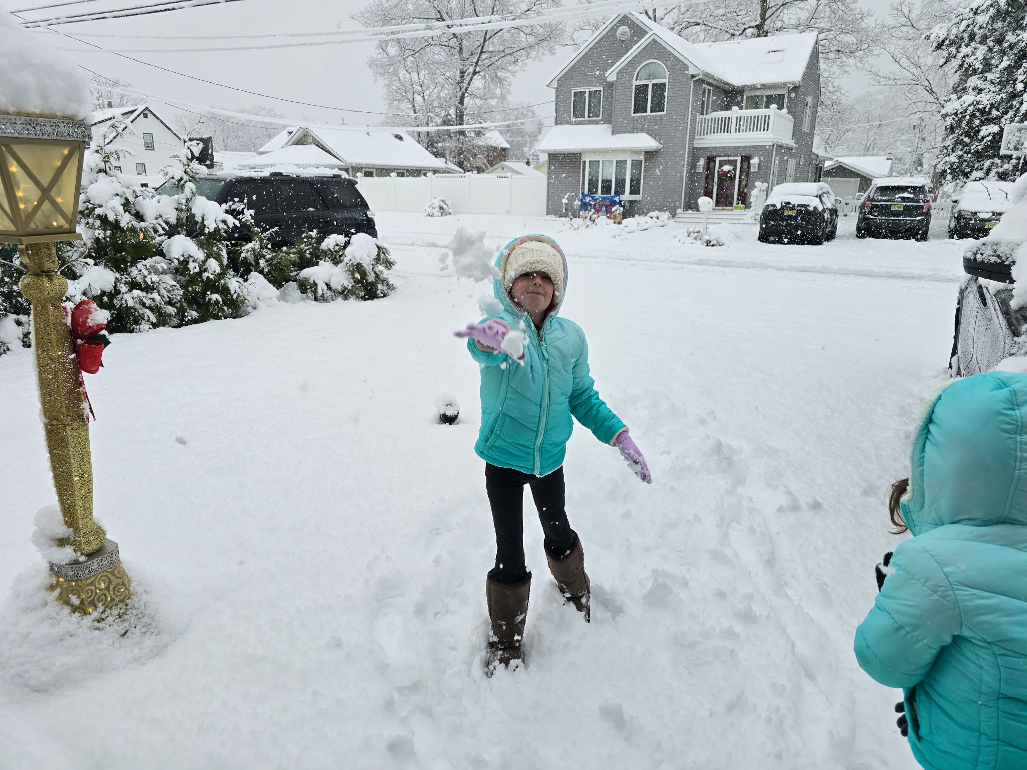
 A WINTER WONDERLAND | Hey, look if there was ever a time to get more snow, it’s a Sunday morning during the holiday season. From Highlands to Cape May, you sent in your photos and videos.
This is what the Jersey Shore looks like!
10AM Sunday
This is turning into a legit winter storm! Over 6″ of snow fell in some parts of the Jersey Shore and it has to do with one band of heavy snow that formed.
10AM Snowfall totals
6.8″ Jackson
6.6″ Upper Freehold
5.7″ Tinton Falls
5.7″ Toms River
5.1″ Lavallette
4″ Hammonton
3.1″ Ocean Acres730AM Sunday:
SUNDAY SNOW FORECAST UPDATE: Up to 4″ of snow has fallen at the Jersey Shore so far. The rain-snow line exited the coast around sunrise and now, it’s snowing everywhere. Once the snow ends, it’s getting windy. And that means brrrrr. Never worry about missing severe weather warnings again.
Get a recorded call from me when your location is impacted. WeatherCall ensures you stay informed for just $15 a year. Sign up: https://ngorder.wxriskalerts.com/db_app2.php?station=cajx
-

Submit your snow measurements to win an Amazon Echo Dot!
To celebrate Sunday’s snow, submit your snow totals to win an Amazon Echo Dot!
 Take a photo of your snow measurement with the ruler in the ground.
 Post the photo on Meteorologist Joe Martucci’s Facebook page, in the comments of this post with your location. Tag three friends.
 Earn an EXTRA entry. Submit your photo at www.bit.ly/WxPhoto to be featured on our LIVE Jersey Shore Weather Channel on YouTube (watch at https://www.youtube.com/@joemartwx/streams or search “Joe Martucci” on your TV app).
 -

Rewatch our LIVE weather show on Sunday’s snow in NJ
We’re covering the shore like nowhere else at Cup A Joe Weather and Drone! Work with us.
NJ beaches generate billions in revenue, supporting thousands of jobs and businesses. If they erode, our economy collapses. Federal beach funding was cut in 2025. Only the American Coastal Coalition fights 24/7 in DC to restore it. Protect your beach and business. Join today: americancoastalcoalition.org
-
Our 1st call Sunday Snow forecast: “Plowable snow for some!”
FRIDAY’S FORECAST: It’s here! Our first widespread snow for the Jersey Shore will be Sunday. It all begins around midnight. I have your first call snow forecast, when it’ll start/stop and your full weekend forecast. Never worry about missing severe weather warnings again.
Get a recorded call from me when your location is impacted. WeatherCall ensures you stay informed for just $15 a year. Sign up: https://ngorder.wxriskalerts.com/db_app2.php?station=cajx
-

Sunday (12/14) SNOW is looking likely for the Jersey Shore now…
THURSDAY’S FORECAST: The whipping winds will send us back to the arctic chill. That arctic chill when then likely set up our first widespread Jersey Shore snow! Shovelable snow? Probably. Plowable? Tune in.
Follow my work: www.cupajoe.live
Jolt your brand, advertise with me: joe@cupajoe.live -
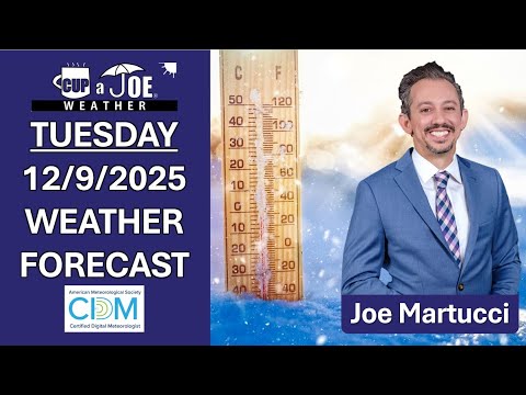
🥶DECEMBRRRR! | Tuesday, 12/9/2025 NJ Weather Forecast
TUESDAY’S FORECAST | December’s weather has been cold and today’s the same! It’s our 2nd December in a row where the shore starts off in the freezer. If you’re sick of the cold already, I have one “warm” weather thought for you in the forecast. However, snow could be here Sunday. Follow my work: www.cupajoe.live Jolt your brand, advertise with me: joe@cupajoe.live
-

First SNOW of winter underway, for some | Friday, 12/5/2025 Weather Forecast
FIRST SNOW IS HERE | We’re getting reports of snow flakes flying near Cape May. Now, we’ll track that light snow up the coast as we go into Friday morning. What your generic weather app won’t tell you? Icy roads that are possible early Saturday.
Never worry about missing severe weather warnings again. Get a recorded call from me when your location is impacted. WeatherCall ensures you stay informed for just $15 a year. Sign up: https://ngorder.wxriskalerts.com/db_app2.php?station=cajx -

A Supermoon and the 1st Snow | Thursday, 12/4/2025 Weather Forecast
THURSDAY’S FORECAST | Our 1st snow of the season is on pace to fall over parts of the Jersey Shore on Friday. I have one big change in the forecast compared to yesterday you’ll want to tune in for. Also, happy Full Cold Supermoon day!
-

Historic 1st Snows at Jersey Shore: Facts and Figures
The first snow of the season at the Jersey Shore is usually something to smile about. It’s light and fun. Maybe just a few flakes in the air or a quick snow shower that melts fast. It makes you think of cozy things: a warm fire, snow on the sand at the beach, or a surprise day off from school or work.
At two weather stations near the Jersey Shore – Atlantic City International Airport and Lower Township – the first snow average is 1.6 inches deep. That’s not much. Most people think it’s more fun than trouble.
However, sometimes the first snow is a big surprise.
Four times at Atlantic City International, and three times in Lower Township, the very first snowy day of the season dropped more than 6 inches. That’s a lot for the first one.
I love snow any time, but a huge first snow can catch everyone off guard. It’s like playing a big game without warming up, or running a race in brand-new shoes. Nobody is ready yet. Meteorologists might miss a forecasting tidbit. Road crews might not put out enough salt and plows. Drivers forget to go slow and careful like they do later in winter. That makes slippery roads extra dangerous.
On average the first real snow at the Jersey Shore waits until the second half of December. However, there are a few times in weather history when snow has been noteworthy and early.

December 5, 2002
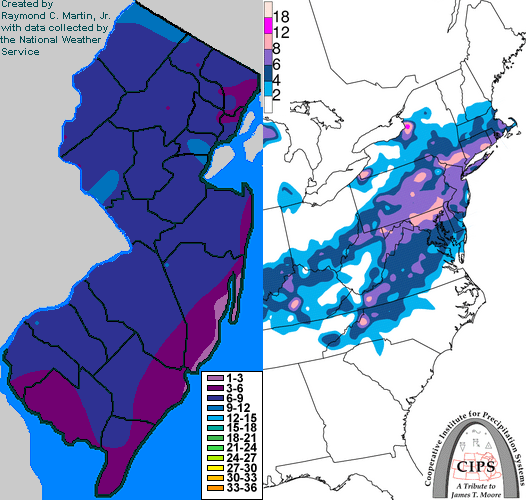
In 2002 the first snow of the season at the Jersey Shore was a nor’easter that dropped more than 6 inches of snow.
Every county in New Jersey had snow, according to NOAA. An area of low pressure developed on a frontal boundary along the Gulf Coast states. Eventually, that low pressure moved through the Southeastern United States, went off the North Carolina coast and quickly raced northeast, according to Raymond C. Martin Jr. It was a nor’easter.
Snowfall totals were sizeable:
- 7.6 inches in Estell Manor, Atlantic County
- 7.0 inches in Hammonton, Atlantic County
- 6.0 inches in Woodbine, Cape May County
- 5.5 inches in Green Creek, Cape May County
- 5.0 inches at Atlantic City International Airport
Perhaps more impressive was that these totals were greater than the snow seen the entire previous winter in much of South Jersey. This was in the middle of a long stretch of colder-than-average temperatures. The snow that fell took six days to fully melt across the area as high temperatures stayed below 35 degrees nearly every day from Dec. 4 to Dec. 10.
November 30, 1967
Before 2002, you had to go back 35 years to experience a first winter storm as significant for the Jersey Shore.
At ACY Airport 7.8 inches of snow fell, the second largest leading snowfall of the season on record (a late start in 2022 was higher). Lower Township experienced 3.0 inches of snow.
This snow engulfed much of the Mid-Atlantic. A Baltimore Sun headline proclaimed: “Near Record November Snowfall Catches City Without Its Plows.”
November 6, 1953
This is one of the largest first snows on record, and one of the earliest, too. Snow spread from western North Carolina to New England.
This wasn’t a 100% snowstorm; 3.2 inches of snow at ACY Airport mixed with a total of 3.98 inches of precipitation. In essence, about 10% of the precipitation that fell was snow. Still, it counts.
Places farther south saw less snow mixed in. By the time you went to Lower Township, the storm was all rain. The Cape May Bubble was still alive and well then, too.
The New York Times wrote that New York’s highways were covered in an icy sheen and many motorists going upstate had to sleep overnight in their cars.
The storm was tropical at first. It was a tropical depression that moved across Florida. It then transitioned from a warm-core, tropical storm, into a cold-core, nor’easter. Ready for the storm was a huge mass of cold air in the Northeastern United States. That turned what was warm rain into some snow.
December 8, 1928
The third biggest first snow of the season in Lower Township’s long stretch of weather records (back to 1897), was a pure snowmaker, even at the immediate coast.
Lower Township saw 9.6 inches of snow on 0.80 inches of precipitation, according to NOAA. That’s a snow ratio of 12:1, meaning this wasn’t a sloppy, wet mess of snow, either.
ACY Airport wasn’t around yet. However, Atlantic City kept snow records then and they were blanketed in 3.9 inches of snow. High temperatures stayed in the 30s for the next two days after that, keeping the snow on the ground, too.
Archive weather maps from NOAA show that this was a coastal storm. Low pressure the morning of Dec. 8 was roughly 40 degrees north latitude, and 75 degrees west longitude. Today, that’s known as the “benchmark,” or the position coastal storms should cross to bring at least some snow to the coast. Winds were from the north or northeast at the Jersey Shore, pumping in the icy air.
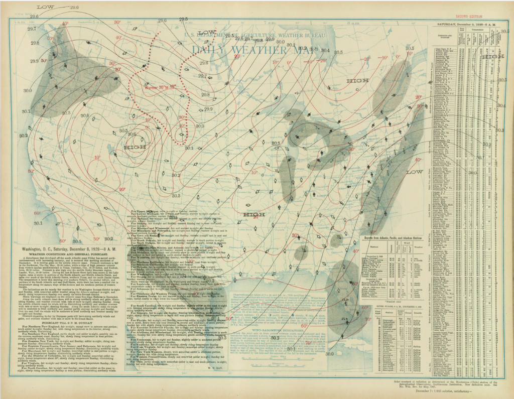
The surface weather analysis for the Dec. 8, 1928 snow. The National Weather Service was a part of the United States Department of Agriculture then. Thanksgiving Day, 1912
Talk about cold turkey. Nov. 28, 1912, brought a statewide blanket of snowfall, delivering a rare “White Thanksgiving.” In fact, it has an argument to claim a spot as the snowiest Thanksgiving on record statewide.
In Lower Township, 4.5 inches fell. In Atlantic City, Northfield and Tuckerton, 4.0 inches fell.
Barely an inch of snow fell in Taylor Ham land in the northern part of the state (yes, there’s a Central Jersey).
I imagine there were a lot of melted (dirt) roads that turned into ice at night. The days following it were well above freezing during the day, dropping a good bit below freezing at night.
Like the early 1928 snow, this storm was a coastal storm. Known as a Miller A type storm, it began off the Georgia coast. It quickly moved north-northeast, passing almost right at that 40-degree north latitude, 75 degree west longitude benchmark.
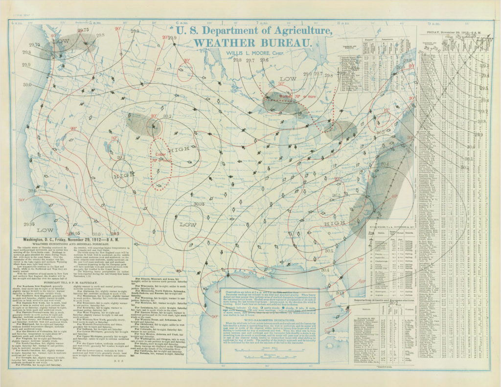
The surface weather analysis for the Thanksgiving 1912 snow. The National Weather Service was a part of the United States Department of Agriculture then. What are your snow thoughts?
Love it? Hate it? You want one snow and then that’s it? Drop me a note on social media or email.
Joe Martucci, a certified broadcast meteorologist and digital meteorologist, is also the president and director of meteorology for Cup A Joe Weather and Drone. You can connect with him at cupajoe.sparkable.opalstacked.com/.