THURSDAY’S FORECAST | It’s sunny with a gentle wind out of the northwest… Very similar weather to what we had Sept. 11, 2001 at the Jersey Shore. Coastal flooding will be around for one more day. Then, you’ll love this weekend forecast!
Follow my work: www.cupajoe.live Jolt your brand, advertise with me: joe@cupajoe.live
WEDNESDAY’S FORECAST | Coastal flooding will grip the area today. A coastal flood advisory is in effect. All of that is true despite it being a mostly dry day! Inland is just damp and breezy. The sun comes out for 9/11 Memorials, though.
Follow my work: www.cupajoe.live Jolt your brand, advertise with me: joe@cupajoe.live
TUESDAY’S FORECAST | Good morning! It’s bright and brisk today, with a stiff wind out of the northeast. A mini coastal storm will pass NJ tonight into Thursday. It’s not a big deal but you’ll want to tune in to see how it’ll impact you.
Dominate your fantasy leagues and bets with weather-driven data. Meteo Oddss gives you innovative tools, player/game weather impacts, and detailed forecasts. Join FF+ by using the code WEATHER and get 50% off, for life! Turn forecasts into fantasy wins — only at www.meteoodds.com.
📹SATURDAY’S FORECAST | Most of the daytime hours are dry! Get work done, hang by the water, go to the Tinton Falls Diamond Jubilee. It’s later in the day when flooding rain and strong storms threaten. I have your full Shore 7-day here.
Captain’s Tree Service handles all your tree needs, including tree removals, trimming, pruning, and 24/7 emergency care. They’re reliable, affordable, and trusted by families. Call the Captain today for a free estimate at (856) 883-7682!
FRIDAY’S FORECAST: Summery today, summery and stormy for Saturday. It’s not a washout! However, there will be strong storms you’ll need to pay attention to I talk about in this video. Enjoy the sun and warmth in the meanwhile. Never worry about missing severe weather warnings again.
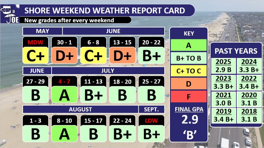
The past 11 weekends at our beach towns graded a ‘B’ or above, but it still wasn’t enough as 2025 was the lowest performing summer in the eight years of my Shore Summer Weekend Weather Report Card.
How the report card is graded
Since 2018, we’ve graded the shore summer weekends from Memorial Day to Labor Day. That’s Friday to Sunday, but also Mondays for Memorial Day and Labor Day. Fourth of July is either included in the weekend or on its own. It was July 4-7 for the 2025 edition.
I say we’ve graded because you shape the report card. You helped set the criteria for the perfect ‘A’ for your summer shore weekends.
An ‘A’ requires temperatures between 75 and 85 degrees, no rain, winds between 5 and 15 mph, low humidity and sunny to partly sunny skies. This report card covers Cape May to Sandy Hook, so if it’s 90 degrees far south, but 85 degrees everywhere else, that won’t ruin a perfect ‘A’ grade.
The 2025 report card for the Jersey Shore
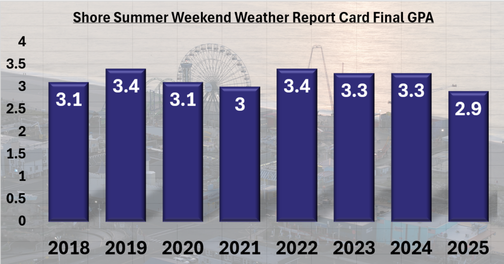
The final grade point average for the 15 summer weekends was a 2.9; good enough for a ‘B,’ but not good enough to get us out of eighth place of the eight summers I’ve graded. You have to look at the beginning of the summer to understand why.
“The reason for these gloomy, cooler weekends is part bad weather luck, and part science,” I wrote on June 19.
New Jersey sat in the middle between two air masses; the jet stream floated over the state. That brought the cool, stormy weather. Then, in a stroke of bad luck, the same pattern repeated itself every seven days, on the weekends.
The warm, bright summer weather that most of us know and love doesn’t settle in until mid-June. Poor weather weekends early in the season are common. Still, 2025 was the worst start in our eight-year history of report cards up until then. After that, the Jersey Shore studied hard to bring up its grade, but 2025 never broke out of last place.
The 11 weekends, from June 20 to Labor Day weekend, were all either a B, B+ or an A. If we just looked at those, the grade point average would be a 3.3; that’s a B+! This included a perfect ‘A’ for the Fourth of July weekend. I was away on vacation, but just talking with you and seeing the weather data, it’s fair to say it was the most comfortable Independence Day weekend in years.
We also had another ‘A’ for Aug. 8-10. Like most of August, the humidity stayed low and the amount of sunlight stayed high.
This past weekend, Labor Day, earned a B+. The only downside was it was a bit too cool, in the low 70s for highs most days. However, it was plenty sunny, not humid at all and had pleasant breezes. It’s a great sign of the Locals’ Summer September to come.
This was the lowest grade in the history of the report card. However, the 2.9 is just half a point away from the highest grade earned in the summers of 2022 and 2019. In other words, the shore never has a poor summer, climatologically speaking.
The eighth annual Shore Summer Weekend Weather Report Card
Furthermore, there was plenty of good weekend weather after Father’s Day, when summer kicks into high gear here.
Final grade point averages by year
2025 – 2.9 (B)
2024 – 3.3 (B+)
2023 – 3.3 (B+)
2022 – 3.4 (B+)
2021 – 3.0 (B)
2020 – 3.1 (B)
2019 – 3.4 (B+)
2018 – 3.1 (B)
How will September’s weather be?
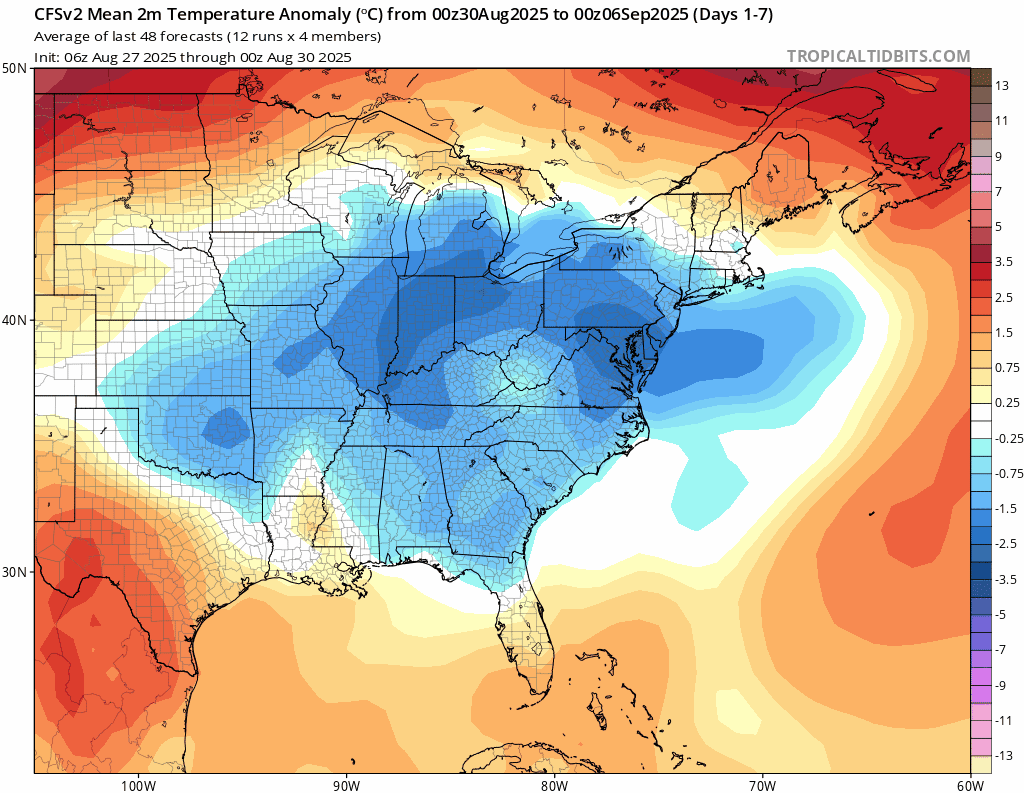
Temperatures should wind up at or just below average for the month of September. I don’t see a big change on the horizon taking us out of the generally cooler and drier weather pattern we’ve been in since the beginning of August.
The CFS forecast computer model for the month of September. The animation is for a week timeframe, seen on the upper left. The blues indicate cooler than average temperatures, which NJ is expected to see for most of September. (via TropicalTidibts.com)
High pressure should generally center itself in Pennsylvania or West Virginia. That will bring us another drier-than-average month, unless a tropical system comes through.
Then, since winds spin clockwise around high-pressure systems, our winds will generally be out of the northeast. That should keep ocean water temperatures in the 70s most of the month, but also keep our on-land high temperatures mostly in the 70s as well.
So, it will be very comfortable with plenty of good days to spend by the water for Locals’ Summer September.
We do need the rain, though. While not exactly known at the time of this writing, the beach towns should wind up with a top 10 driest August on record, according to NOAA’s Southeast Regional Climate Center. The mainland was still below average, just not as much. Farther away, Millville should be the driest August on record. Drought in New Jersey spread and worsened tremendously last September. Let’s hope that doesn’t happen again.
Thanks for following the Shore Summer Weekend Weather Report Card. I hope you enjoyed seeing the grades as much as I like posting about them in my videos and on social media. Now, happy locals summer!
Joe Martucci, a Certified Broadcast Meteorologist and Digital Meteorologist, is the President and Director of Meteorology for Cup A Joe Weather and Drone. You can connect with him at cupajoe.sparkable.opalstacked.com/.
WEDNESDAY’S FORECAST | The sunshine and comfortably mild temperatures continue for another day! Turns out, these cool mornings are making history as well for us at the shore. Enjoy the sunshine! Rounds of rain return Thursday night.
Follow my work: www.cupajoe.live Jolt your brand, advertise with me: joe@cupajoe.live
Labor Day is over and now it’s time for Locals’ Summer! Happy back to school day, too. It’ll feel like school weather. It’s another cool morning leading to a warm day! A series of cold front will pass with a few rounds of showers. Let’s see how wet it’ll be. www.cupajoe.live
Meteorologist Joe Martucci and NJ State Climatologist Dr. Dave Robinson shared the same August recap and wardrobe choice of a blue polo shirt. Turning to the weather, the two detail Hurricane Erin’s coastal devastation with record-high summer tides and erosion.
They noted cooler-than-average temperatures, a chilly month start and end, and severe drought conditions, with North Jersey under a drought for the first time in months. The Rutgers 2024 Climate Report highlights ongoing drought and future weather risks.
Recap the month of weather that was. It’s all Jersey, with two of Jersey’s best weather guys. New Jersey State Climatologist Dr. Dave Robinson as well as Meteorologist Joe Martucci, owner of Cup A Joe Weather and Drone take you through the temperatures, rain, snow, coastal flooding and much more every episode. New episodes come out around the beginning of every month.
Hurricane Erin glanced the Jersey Shore with an indirect blow, causing historic summertime flooding, dangerous surf and beach erosion. It marks the beginning of the peak of hurricane season, which promises to be active in the Atlantic Hurricane Basin.
How will the rest of hurricane season be?
It will probably be more active than usual, with a typical risk to the Jersey Shore.
Colorado State University updated its forecast for August. For the hurricane season as a whole, from June to November, they project that 2025 will have 16 named storms. Of those, eight of them are expected to become hurricanes and three of them major hurricanes – Category 3, 4 or 5 storms.
On average, there are 14 named storms – seven hurricanes and three major hurricanes each year. This year is a bit more active than usual. As of Aug. 23, we’ve already had some storms in the Atlantic, so the forecast predicts 11 more named storms – seven hurricanes and two major hurricanes to come. There’s still a lot of energy left in the hurricane season and we hope it doesn’t hit New Jersey.
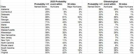
Colorado State University estimates the chances of a storm coming within 50 miles of New Jersey from Aug. 5 to Nov. 30 as follows:
25% chance of a named storm
8% chance of a hurricane
1% chance of a major hurricane
Probabilities of a named storm, hurricane or major hurricane being within 50 miles of each coastal state (via Colorado State University).
All of that is about the average for the state. While Hurricane Erin impacted the shore, the storm’s center was 450 miles away from New Jersey at its closest, so that didn’t count. The peak of hurricane season is here.
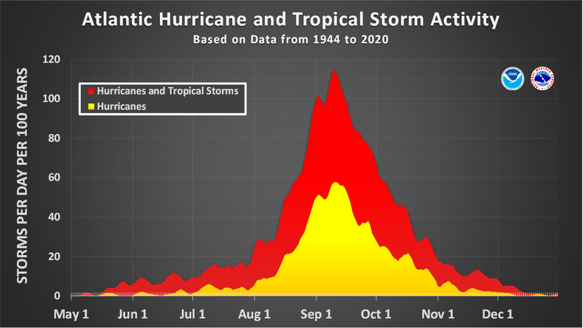
On average, the most active stretch of hurricane season is from mid-August to mid-October, peaking around Sept. 10, according to the National Hurricane Center in Miami, Fla. Not only are there the most storms during this time, but they’re typically the most intense. That’s due to the Atlantic Ocean, Caribbean Sea and Gulf of Mexico (Gulf of America) having their widest range of water temperatures: 80 degrees.
Furthermore, Cabo Verde (or Cape Verde) storms are more likely during this time. Like Hurricane Erin, these are the far traveling storms that roll off the West Coast of Africa and travel across the ocean, giving it ample time to strengthen and organize.
Key factors for the rest of hurricane season
Colorado State University points to a few ingredients they’re paying attention to through November.
The first one is sea surface temperatures. The central and eastern parts of the Atlantic Ocean were well above average in July. However, they’ve trended toward seasonable recently.
The highest hurricane activity happens when the tropical Atlantic Ocean is more above average than the rest of the Atlantic Ocean. In other words, if the tropical Atlantic Ocean is 2 degrees above average, and the rest is 1 degree above average, that usually means more tropical cyclones. That’s not the case now given that Hurricane Erin cooled the water as it passed through the tropics, but this will be studied.
Also, hurricanes can be affected by something called El Niño, La Niña, or neutral conditions (sometimes called “La Nada” for fun). This year, we’re close to neutral or La Niña, which means a slightly more active hurricane season.
The last significant factor is the high amount of wind shear in the Caribbean Sea. Wind shear weakens hurricanes during hurricane season by disrupting their spinning structure, similar to how a strong gust might disrupt a spinning top, making it harder for the storm to stay strong or grow.
If that remains, the hurricanes will be torn apart and weaken if they try to move from Africa into the Caribbean Sea and then northwest into Mexico, Cuba or the United States Gulf Coast.
Wind shear in the Caribbean Sea doesn’t impact New Jersey much, though.
Key messages for N.J.
Hurricane Erin was a good reminder of what tropical systems can do to the coastline. Always listen to public safety officials during a weather emergency. They know how to keep you safe.
If they tell you to leave your area, do it right away. Closing beaches and businesses to evacuate is important, and only happens when it’s really dangerous. They ask you to leave because staying could be very risky.
Now is a good time to make your “Go Bag.” If you attended the Downbeach Community Meeting in Ventnor on Aug. 6, officials from Ventnor, Margate and Longport talked about this. Also, follow what we in the weather community are saying. Hurricanes.gov is the official resource for storm information.
If you follow me on my website or social media that’s great and I love that. However, any degreed meteorologist is trained to deal with these situations.