We’re covering the shore like nowhere else at Cup A Joe Weather and Drone! Work with us.
NJ beaches generate billions in revenue, supporting thousands of jobs and businesses. If they erode, our economy collapses. Federal beach funding was cut in 2025. Only the American Coastal Coalition fights 24/7 in DC to restore it. Protect your beach and business. Join today: americancoastalcoalition.org
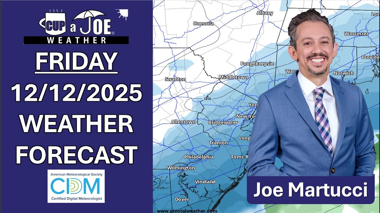
FRIDAY’S FORECAST: It’s here! Our first widespread snow for the Jersey Shore will be Sunday. It all begins around midnight. I have your first call snow forecast, when it’ll start/stop and your full weekend forecast. Never worry about missing severe weather warnings again.
Get a recorded call from me when your location is impacted. WeatherCall ensures you stay informed for just $15 a year. Sign up: https://ngorder.wxriskalerts.com/db_app2.php?station=cajx
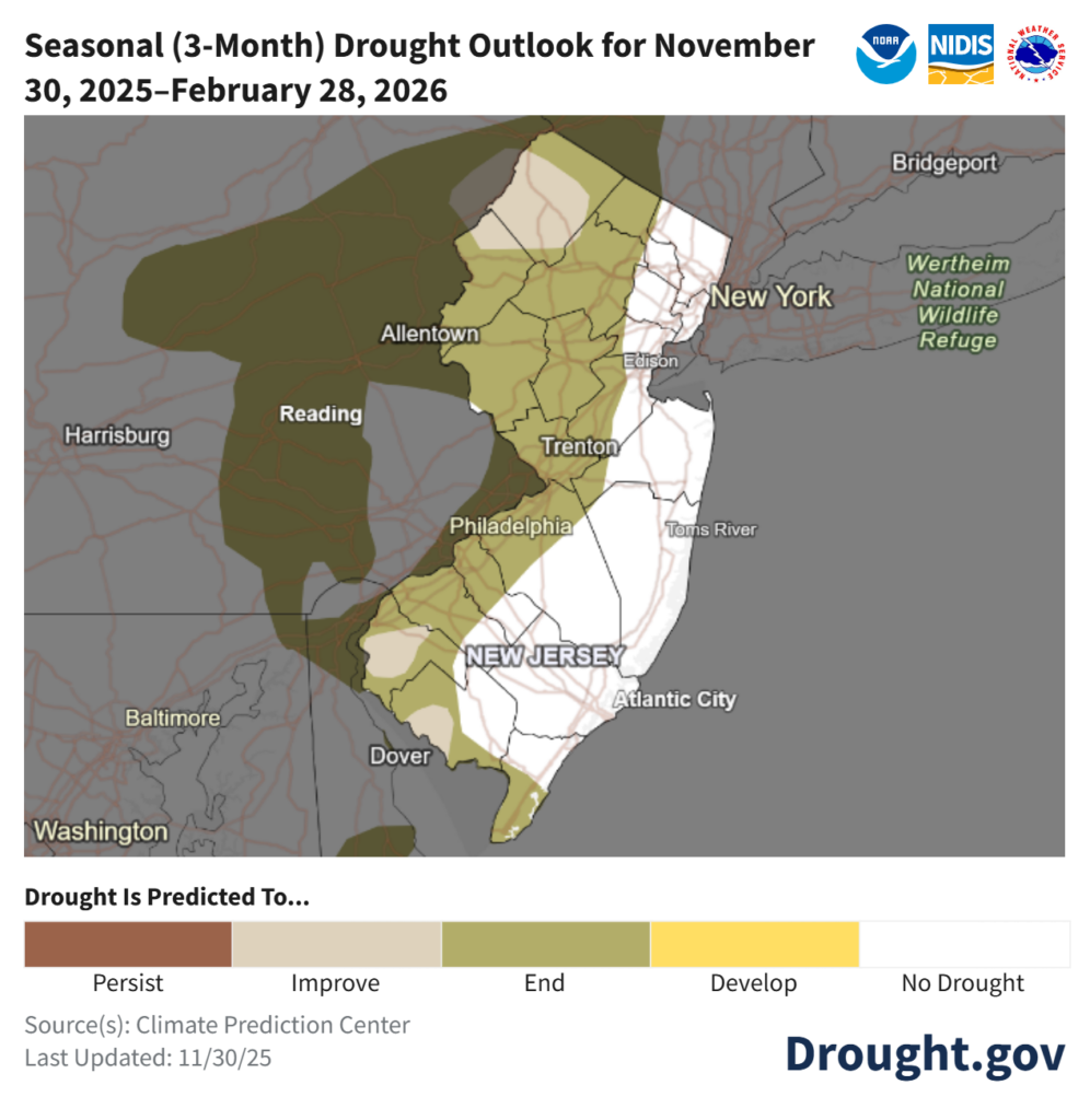
On Dec. 5, the New Jersey Department of Environmental Protection (NJDEP) issued a drought warning for the state. It brings back not-so-distant memories of barely flowing streams and record dry weather. However, unlike the previous drought warning, Jersey Shore fares the best in the state this time around.
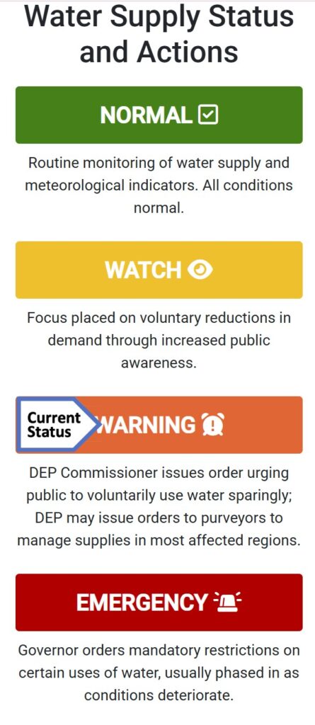
A drought warning is not an emergency yet — it’s an early step to manage water supplies when a drought is starting to happen. It comes after a drought watch, but before a full drought emergency. The main goal of a drought warning is to stop things from getting so bad that the state must declare a real water emergency.
Via the NJDEP
“All New Jerseyans are requested to follow water conservation practices, and to use water wisely, particularly when using water outdoors,” the NJDEP wrote in their statement.
To be clear, there are no state mandatory water restrictions in place. That can only be issued if the governor declares a drought emergency. However, like we saw with New Jersey American Water last fall, water companies can issue their own restrictions to users.
The last drought warning was in effect from November 2024 to June 2025. That came just after the driest autumn on record for New Jersey. Even after June, the NJDEP still had Atlantic and Cape May counties on a drought watch, to increase our awareness of the impact on our water supply.
In the previous drought warning, the Jersey Shore had the most severely dry conditions. This time though, the coast is making out better than our friends to the west and north.
The United States Drought Monitor, which is unaffiliated with the NJDEP, issues drought updates every Thursday, using data from the previous Tuesday.
As of Dec. 4, the most recent update at the time of this writing, Cape May County, from Sea Isle City to Dennis on south, is in the first stage of drought, called “moderate drought.” The rest of the Jersey Shore is completely drought-free, though. Data shows that 55% of New Jersey is in drought, though.
Most of that is on the Delaware Bayshore and then roughly the New Jersey Turnpike northwest. About 10% of the state is in the second level of drought, known as severe drought. That’s mainly in Sussex, Salem and Cumberland counties.
The drought monitor looks mainly at the precipitation, soil, rivers and plants. Meanwhile, the NJDEP focuses on reservoirs and drinking water. Both are useful tools, though we in New Jersey will act based on the NJDEP, not the drought monitor.
Either way, both agree that the Jersey Shore is least impacted by drought.
Then came November. It was drier than average. Cape May and Atlantic counties picked up between 1 to 2.25 inches of precipitation. The average for November is 3.37 inches at Atlantic City International Airport, and 3.44 inches at Sen. Frank S. Farley Marina in Atlantic City, according to the National Oceanic and Atmospheric Administration. So, it was dry.
It was even drier than average in the north. November in Boonton (Morris County) and Belvidere (Warren County) were among the driest 20% on record.
At the same time, the shore continues to pick up the most from whatever rainmakers we get. On Dec. 2, over an inch fell in Egg Harbor Township, Cape May Court House and Atlantic City. Much of Northwest New Jersey had less than a half inch.
However, we need to look at more than just what’s happened recently to get a picture of our drought situation. Drought usually is long term, occurring over multiple years. We’re probably in the middle of one. We’ll improve at times, but the ground in New Jersey is dry and has been dry for at least a year. A wetter month here and there is good. A months-long, sustained period of ample rain and snow is needed to buck this trend, though.
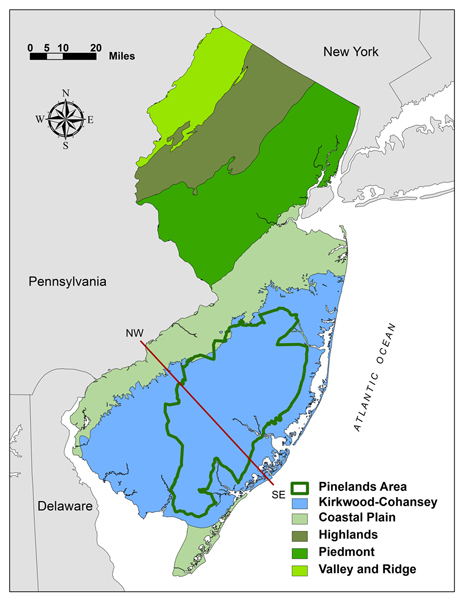
Groundwater levels and stream flows over the past 90 days are “extremely dry” in the Coastal South region, according to the NJDEP’s Dec. 7 update. That’s roughly Toms River to Seaside Heights on south. It’s been this way for multiple weeks. We rely on groundwater from the Kirkwood-Cohansey aquifer for our freshwater needs.
The location of the Kirkwood-Cohansey aquafer in blue, within New Jersey (via the state of New Jersey)
There was improvement during the summer, but we haven’t been “near or above normal” in at least a year.
Like last year, having a drought during the cool season is better than having one during the warm season. Sprinklers are turned off, pools and water parks are closed and water usage is just less. Moreover, the sun is weak and doesn’t evaporate as much water as in the summer.
So, does that give us enough runway to pull out of this drought? NOAA believes so. For the areas the US Drought Monitor has in a drought now, an improvement is expected over the winter according to their Nov. 30 update. For December, there is a lean toward a wetter (perhaps whiter) than average month.
For now, reduce water usage where you can. It’s not as big of a problem as last winter. This will be monitored closely.
Joe Martucci, a Certified Broadcast Meteorologist and Digital Meteorologist, is the President and Director of Meteorology for Cup A Joe Weather and Drone. You can connect with him at cupajoe.sparkable.opalstacked.com/.
THURSDAY’S FORECAST: The whipping winds will send us back to the arctic chill. That arctic chill when then likely set up our first widespread Jersey Shore snow! Shovelable snow? Probably. Plowable? Tune in.
Follow my work: www.cupajoe.live Jolt your brand, advertise with me: joe@cupajoe.live
WEDNESDAY’S NJ WEATHER: After a frigid Tuesday, we’re officially in the top 10 for the coldest starts to December on record. Today will be the “warmest” day of the next 7 but it ain’t mild, either. Arctic air will surge back in and widespread light snow may finally get to the coast.
Follow my work: www.cupajoe.live Jolt your brand, advertise with me: joe@cupajoe.live
TUESDAY’S FORECAST | December’s weather has been cold and today’s the same! It’s our 2nd December in a row where the shore starts off in the freezer. If you’re sick of the cold already, I have one “warm” weather thought for you in the forecast. However, snow could be here Sunday. Follow my work: www.cupajoe.live Jolt your brand, advertise with me: joe@cupajoe.live
FIRST SNOW IS HERE | We’re getting reports of snow flakes flying near Cape May. Now, we’ll track that light snow up the coast as we go into Friday morning. What your generic weather app won’t tell you? Icy roads that are possible early Saturday.
Never worry about missing severe weather warnings again. Get a recorded call from me when your location is impacted. WeatherCall ensures you stay informed for just $15 a year. Sign up: https://ngorder.wxriskalerts.com/db_app2.php?station=cajx
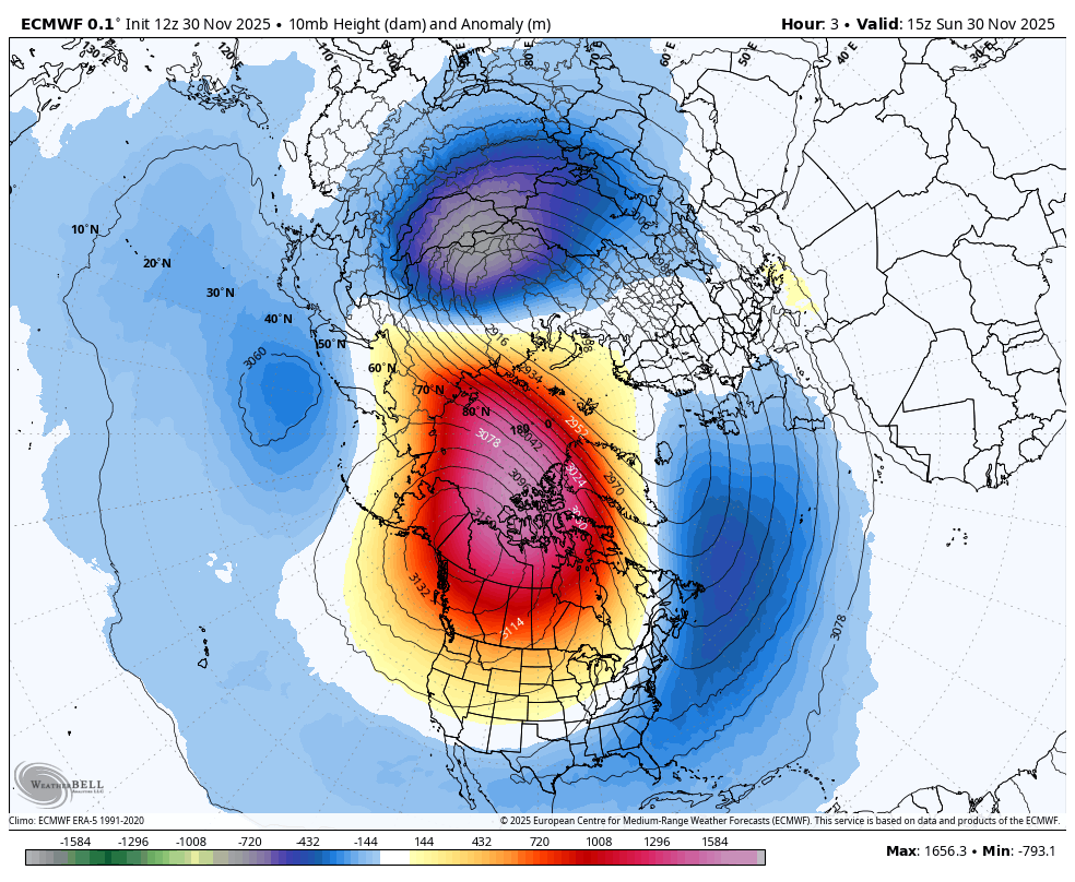
The polar vortex has been poked and distributed in the stratosphere. Now it’s a waiting game as rounds of Arctic air run through New Jersey, reload and sweep through the Northeast again for much of December.
As of Nov. 30, the time of this writing, it was unknown whether the Sudden Stratospheric Warming (SSW) occurred near the North Pole. If the stratospheric polar vortex were disturbed so much that its westerly winds reversed course, causing the SSW, and it happened in November, it would be the earliest in the satellite era (1968).
Either way, though, the polar vortex’s spinning top at the North Pole was disrupted. Much warmer-than-usual air filled into the Arctic about 100,000 feet high. The stratospheric polar vortex stretched south into North America. Specifically, it moved into Western Canada and Alaska.
The height above sea level where you reach 10 millibars of pressure (lines) with its departure from average in blue, yellow or red for Nov. 30. Notice the red area in Western Canada and Alaska. That’s where the center of the polar vortex was (via WeatherBell).
The extremely cold air in the stratospheric vortex almost never mixes directly down to the surface. Instead, the SSW changes the large-scale circulation, which then allows pre-existing surface-level Arctic air (from northern Canada, Siberia, etc.) to plunge southward in the troposphere.
As of Nov. 30, that Arctic air had surged south from the North Pole to Hudson Bay and Quebec, Canada, according to Ryan Maue, a meteorologist and climate scientist at WeatherTrader.
The jet stream, the river of air about 30,000 feet high, which separates polar and tropical air masses, then becomes wavy, moving south to north, to south again. The jet stream is in the troposphere.
That clash of warm and cold air from the jet stream also causes cold-core storms, like a nor’easter to form at the surface. For now, though, let’s focus on the cold.
When will cold air outbreaks occur at the Jersey Shore?
There are three times for colder-than-average temperatures:
1. A continuation of the current cold through Dec. 6
2. Dec. 8-10
3. Dec. 14-18
These aren’t long stretches of cold, however, it will be 10 or more degrees below average for many of those days. That translates to high temperatures in the upper 30s to low 40s. For low temperatures, this means lows on either side of 20 degrees inland. Meanwhile, the shore would see lows of 25 to 30 degrees.
Remember that our coldest day of the year, on average, occurs in the second half of January. So, while they don’t sound extremely bitter for late January standards, this is not what it should feel like in early December.
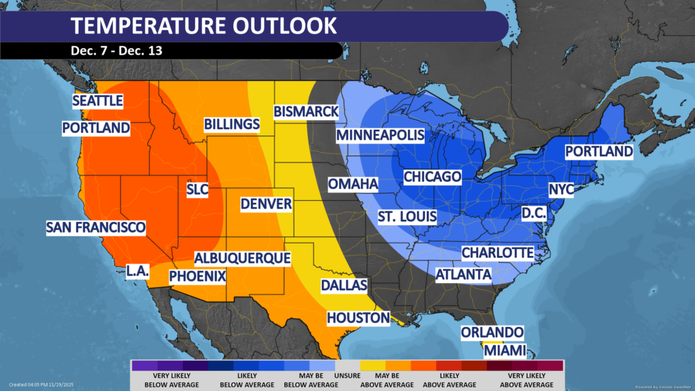
The National Oceanic and Atmospheric Administration (NOAA), forecasts Dec. 7-13 to be below average for the Northeast and Great Lakes states. However, NOAA has the most confidence on below-average temperatures for every county in New Jersey except for Cape May County – a sign that the Cape May Bubble is still strong year-round.
All kidding aside, it will be a chilly start to climatological winter, which runs from Dec. 1 to Feb. 28, the coldest three months of the year, on average.
Forecasting what days snow will fall at the Jersey Shore more than five days out is nearly impossible. I won’t do that. However, there are two forces at play. How much snow we see, or don’t see in December will prove which force was stronger.
A colder-than-average December is simply better for snow than a warmer-than-average December. It gives you more opportunity for snow. It’s that simple.
On the other hand, a pattern appeared in November. When it’s dry, it’s colder than average. When there is precipitation, it’s at or warmer than average. That cold and dry, or mild and wet pattern drives snow lovers crazy. It’s a function of the storm track being at or west of New Jersey. That brings more southerly, warmer winds around counterclockwise-spinning storms.
At the Sen. Frank S. Farley State Marina in Atlantic City, 10 days also had precipitation in November. Eight of them were above average or within a degree of average, according to NOAA. Ten days of precipitation also happened at Atlantic City International Airport; six of them were above average or within a degree of average.
To see how the polar vortex could interact for yourself, go to a weather forecast model website like WeatherBell (subscription needed) and look at the 2PVU (potential vorticity units) forecast, which looks at the boundary between the troposphere and the stratosphere.
Where you see the blues and purples indicates the outline of the polar vortex boundary. In a strong polar vortex, it is compact, circular and centered near the Arctic. If it’s not, like the first half of December, that means the polar vortex has weakened, which eventually allows frigid air at the ground to spill places south.
Joe Martucci, a Certified Broadcast Meteorologist and Digital Meteorologist, is the President and Director of Meteorology for Cup A Joe Weather and Drone. You can connect with him at cupajoe.sparkable.opalstacked.com/.
THURSDAY’S FORECAST | Our 1st snow of the season is on pace to fall over parts of the Jersey Shore on Friday. I have one big change in the forecast compared to yesterday you’ll want to tune in for. Also, happy Full Cold Supermoon day!


