Tag: Jersey Shore

  • 2025’s Ocean was so Warm in NJ, It Almost Broke a Record

    2025’s Ocean was so Warm in NJ, It Almost Broke a Record

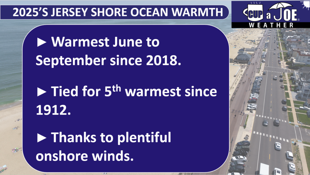
    The summer tide came rolling in this year much warmer than 2024. In fact, the water we enjoyed was tropical enough to be one of the warmest on record at the Jersey Shore.

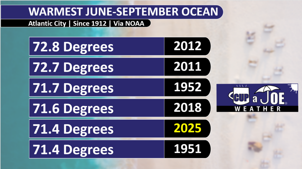
    From June to September, peak beach season, the ocean water temperature from the gauge at Atlantic City’s Steel Pier averaged 71.4 degrees. That is tied with 1951 for the fifth warmest season since records began in 1912.

    This was exactly five degrees warmer than last year, at 66.4 degrees. Remember last year? The water was cold. You sweated on the sand but shivered in the ocean.

    June and July had zero days with a water temperature above 75 degrees last year in Atlantic City. In fact, 11 July days were in the very chilly 50s, and 55 degrees was the 8 a.m. water temperature on July 18, 2024.

    The old saying, “life’s at ease with an ocean breeze” is true. Wind direction all summer, and Locals’ Summer September long, play the critical role to this top five ranking.

    There are three main factors that drive water temperatures.

    The Sun: In spring and summer, the sun is higher in the sky, so it warms up the ocean water faster. In fall and winter, the sun is lower, so the water stays cooler.

    The Currents: In New Jersey, there is a warm ocean current called the Gulf Stream. It starts near Florida and flows all the way to Europe. It does not always reach New Jersey, but sometimes its swirls, bringing warmer water to the shore.

    Wind Direction: Winds that blow from the east, called onshore winds, push warmer ocean water toward the beach. But winds from the south or southwest bring colder water. When winds blow along the shore, they can cause something called Ekman Pumping. This pushes warm surface water away and pulls up colder water from the bottom of the ocean, where we swim.

    While the sun and currents are constant, the wind direction varies day by day, month to month and, for purposes of this article, year by year. This is why it was warmer.

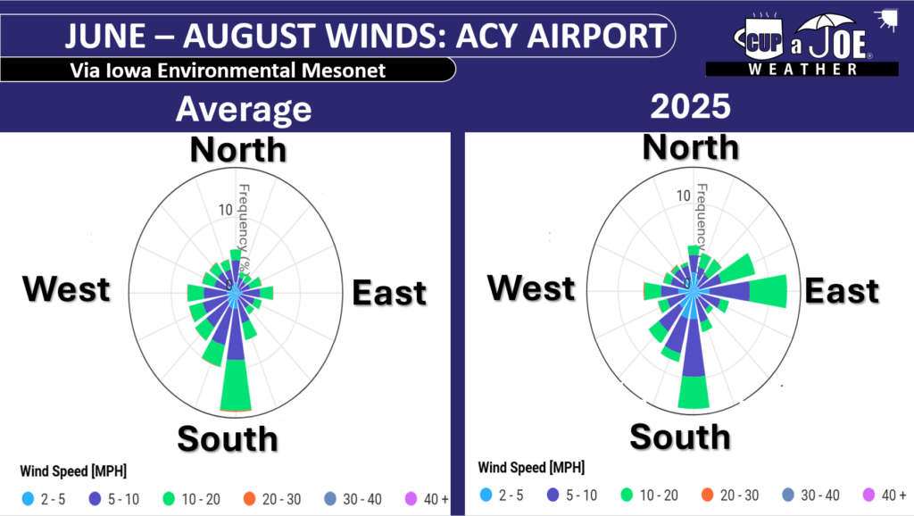
    Onshore winds blew 30% of the time between June and August at Atlantic City International Airport in Egg Harbor Township this year, our closest NOAA weather station with wind direction to Atlantic City.

    The average is 15%. In other words, we had double the number of onshore winds as usual.

    September was the same, with onshore winds roughly 38% of the time in 2025. 27% is the average.

    Those extra onshore winds pushed in some warmer water from the Gulf Stream and limited the amount of colder upwelling. It also led to an August that was cooler than average on land and just about average during September, according to New Jersey State Climatologist Dave Robinson, my other weather dad. Insert YouTube video here.

    The average June to September water temperature is 68.6 degrees. June was the only one below average, at 65.8 degrees. That is not a surprise. However, July (72.9), August (74.8), September (72.1) were all above average.

    If you had to compare it, the sea surface temperatures you experienced this season were more like an average season for Virginia Beach.

    August 16 and 17 were the warmest water days, staying above 80 degrees. June 1 itself had the coldest water, staying below 60 degrees. No surprise there, as the sun is trying to heat up the water.

    We are Going Live!

    Also, I am extremely excited to say that the Jersey Shore’s first 24×7 livestreaming weather channel is going live soon! Thanks to Sparkable (who also runs the Shore Local Website), everything Jersey Shore weather, with a little drone, will be on my YouTube channel and website for your viewing pleasure.

    Tide and marine forecasts, current conditions, forecast videos, radar, and support from our sponsors will all be on there. I also want to see your Jersey Shore photos! Submit your sunrises, snow, thunderstorms and fall foliage to be featured in a special shot on the livestream.

    Keep it on your smart TV or computer all day long. Stay tuned for more details.

  • Tidal flooding now, powerful coastal storm later | 10/9/2025 NJ Forecast

    Tidal flooding now, powerful coastal storm later | 10/9/2025 NJ Forecast

    THURSDAY’S FORECAST | Our nor’easter for Columbus Day weekend is a go. Strong winds, multiple rounds of tidal flooding, heavy rain and waves that chew up the beach. For now, it’s crisp and autumnal. However, there’s still a little tidal flooding around.

    Follow my work: www.cupajoe.live
    Jolt your brand, advertise with me: joe@cupajoe.live

  • Pay attention to next week, it should be NJ’s 1st nor’easter of the Fall

    Pay attention to next week, it should be NJ’s 1st nor’easter of the Fall

    Our first nor’easter of the season will be Sunday-Tuesday. But does it pack a punch for all? Just beaches? Too early to tell. Here’s what I *can* tell you though.

    Get instant weather calls, from me, for your area. Join WeatherCall for only $15/yr. https://ngorder.wxriskalerts.com/db_app2.php?station=cajx

  • Summer’s last stand?! | Tuesday, 10/7/2025 NJ Weather Forecast

    Summer’s last stand?! | Tuesday, 10/7/2025 NJ Weather Forecast

    📹TUESDAY’S FORECAST | A few hours of soaking rain divides today’s summer weather to a big blast of Autumn! Let’s time it out for you and then explain the potential for a nor’easter (gulp) next week.

    Dominate your fantasy leagues and bets with weather-driven data. MeteoOdds gives you innovative tools, player/game weather impacts, and detailed forecasts. Join FF+ by using the code WEATHER and get 50% off, for life! Turn forecasts into fantasy wins — only at www.meteoodds.com.

  • 🤩Beau-ti-ful! | Saturday, 10/4/2025 NJ Weather Forecast

    🤩Beau-ti-ful! | Saturday, 10/4/2025 NJ Weather Forecast

    📹 SATURDAY’S FORECAST | A beau-ti-ful stretch of Jersey Shore weather is here this weekend! Your weather app won’t show you the current Fall Foliage conditions in NJ though.

    Captain’s Tree Service LLC handles all your tree needs, including tree removals, trimming, pruning, and 24/7 emergency care. They’re reliable, affordable, and trusted by families. Call the Captain today for a free estimate at (856) 883-7682!

    Follow my work: www.cupajoe.live
    Jolt your brand, advertise with me: joe@cupajoe.live

  • Temps are movin’ on UP | Friday, 10/3/2025 NJ Weather Forecast

    Temps are movin’ on UP | Friday, 10/3/2025 NJ Weather Forecast

    FRIDAY’S FORECAST | It’s chilly this morning! However, this is the lowest temperatures for a while. We’ll be climbing up the thermometer, just in time for the weekend. Plus, tune in for something your weather app won’t show you: a sun dog!
    Follow my work: www.cupajoe.live
    Jolt your brand, advertise with me: joe@cupajoe.live

  • Absurd temperature swings in NJ | September 2025 Monthly Weather Roundup

    Absurd temperature swings in NJ | September 2025 Monthly Weather Roundup

    The Monthly Weather Roundup is sponsored by Jennifer Ansbach Coaching / The Cozy Thesis — helping students and adult learners Write. Revise. Rise. Learn more at JenniferAnsbach.com.

    New Jersey’s September weather broke the usual patterns. It began with a brisk chill. Then it shifted back to summer warmth. It’s one of only a few times on record when the second half of September was warmer than the first half. Overall, temperatures ended up a bit above average.

    Dave and Joe then noted drought warnings in northern areas. Coastal regions faced heavy rain. Eroding beach sands now threaten winter storm defenses. They also discussed Hurricane Sandy’s 13th anniversary and whether memories of the storm are fading. Stay tuned for updates on hurricane risks and stunning fall foliage.

    Recap the month of weather that was. It’s all Jersey, with two of Jersey’s best weather guys. New Jersey State Climatologist Dr. Dave Robinson as well as Meteorologist Joe Martucci, owner of Cup A Joe Weather and Drone take you through the temperatures, rain, snow, coastal flooding and much more. New episodes come out around the beginning of every month.

    Cup A Joe Weather and Drone: www.cupajoe.live
    NJ Climatologist’s Office: www.njclimate.org

  • The Fujiwhara Effect: When 2 tropical cyclones collide

    The Fujiwhara Effect: When 2 tropical cyclones collide

    This article initially appeared in Shore Local News on 10/2/2025. The article was update to include more current information from Imelda and Humberto on 10/2/2025

    Last week, I mentioned on my digital and social weather channels that Hurricanes Humberto and Imelda could undergo a rare interaction called the Fujiwhara Effect.

    Humberto and Imelda partially made this happen, but not completely. Either way, it doesn’t matter for our Jersey Shore weather forecast. A powerful arctic, high-pressure system kept the rain away from these two storms. However, there were gusts to 40 mph and coastal flooding on Oct. 1 and bad surf continues into the weekend.

    The Fujiwhara Effect, like polar vortex, heat dome and derecho before it, brings a new weather word into public discourse. And for your Shore Local meteorologist, it means I get pumped to explain a new-to-many weather phenomenon.

    What is the Fujiwhara Effect?

    “The tendency of two nearby tropical cyclones to rotate cyclonically about each other as a result of their circulations’ mutual advection,” The American Meteorological Society’s Glossary of Meteorology says. However, let us break that down even more.

    Think of the Fujiwhara Effect as a square dance. Instead of pairs of dancers, they are pairs of tropical storms or hurricanes.

    In square dancing, pairs of dancers spin and move in patterns together. The same is true with the Fujiwhara Effect. Instead of a caller’s instructions, though, storms follow nature’s rules.

    Technically, the Fujiwhara Effect happens when storms are within 900 miles of each other’s circulation. That is the distance from Ocean City, N.J., to Tampa, Fla. That is not much in the vast expanse of the Atlantic Ocean.

    The two storms’ counterclockwise (Northern Hemisphere) or clockwise (Southern Hemisphere) winds will start to spin closer to each other. Once they are about 200 miles apart, one of three scenarios happens:

    1.           The larger storm will absorb the smaller storm into its circulation.

    2.           The two storms will merge, creating one more powerful storm.

    3.           Both storms will weaken due to the increase in wind shear or change of wind direction with height.

    The Fujiwhara Effect is named after Sakuhei Fujiwhara, a Japanese meteorologist who first described this phenomenon as a theory in a 1921 research paper. Turns out his theory was correct.

    Where does the Fujiwhara Effect occur most often?

    The northern Pacific Ocean is the place where it happens the most, the American Meteorological Society reports.

    The Pacific Ocean, specifically the western Pacific Ocean, is the world’s most active tropical cyclone basin, thanks to its very warm water and humidity. Plus, since the Pacific Ocean is the world’s largest ocean, more storms can simply spin around there, and potentially come into contact with each other.

    It is rare to have the Fujiwhara Effect in the Atlantic Hurricane Basin. Records are not kept on them, but they happen only once every couple of years. Compared to the Pacific Ocean, there is less area for tropical storms or hurricanes to develop.

    Also, our ocean has just one main storm track: Off the West Coast of Africa to the Caribbean Islands, turn north between the United States East Coast and Bermuda, and then northeast into the northern Atlantic Ocean. This gives less opportunity for storms to cross paths.

    Notable Fujiwhara Effect storms

    The Fujiwhara Effect likely took place in the Atlantic Hurricane Basin in 2016 when Hurricane Matthew and Tropical Storm Nicole interacted. They did not fully dance with each other, however, Matthew’s path shifted a bit, which brought major flooding to the East Coast of Florida.

    The last time on record that Atlantic storms underwent a full Fujiwhara Effect was in 1995 with Hurricanes Iris and, fittingly for this article, Humberto. On Aug. 23, 1995, Hurricane Iris was on a northern path from the Lesser Antilles in the tropical Atlantic Ocean. Then it interacted with Humberto. The Fujiwhara Effect took place, jolting Iris 300 miles to the east.

    Both storms weakened with the Fujiwhara Effect. After the interaction, Iris was downgraded to a tropical storm, while Humberto was downgraded from a Category 2 to a Category 1 hurricane.

    In the eastern Pacific Ocean, closer to North America, Hurricanes Hilary and Irwin in July 2017 showed a good example of the Fujiwhara Effect when the two made a full pivot around each other as they moved north up the Mexican coastline.

    The storms did not merge. They ended up weakening, in part due to the Fujiwhara Effect, and in part due to moving over cooler water.

    Joe Martucci, a Certified Broadcast Meteorologist and Digital Meteorologist, is the President and Director of Meteorology for Cup A Joe Weather and Drone. You can connect with him at cupajoe.sparkable.opalstacked.com/.

  • 😎High pressure DOMINATES | Thursday, 10/2/2025 NJ Weather Forecast

    😎High pressure DOMINATES | Thursday, 10/2/2025 NJ Weather Forecast

    It’s cool, it’s crisp, it’s calm, it feels like Fall! The NJ Forest Service just released their forecast on when the fall colors will be brightest. We talk about that plus a Locals’ Summer special in the 7-day.

    Follow my work: www.cupajoe.live
    Jolt your brand, advertise with me: joe@cupajoe.live